
Bull Run Occoquan Trail
Virginia Blue Bells, Warblers and a hike along a river
Bull Run Occoquan Trail
Virginia Blue Bells, Warblers and a hike along a river
Details
hilly. We’ll begin at Bull Run Regional Park
The hike will begin at 10:00 am and go about 7 miles (we’ll walk 3.5 miles and then turn back to our starting point). Bring water, sturdy shoes and some snacks.
For those in the Richmond area, we’ll have breakfast at McLean’s at 7:00 a.m. before leaving at 7:45 a.m. for the drive up.
https://www.novaparks.com/parks/bull-run-occoquan-trail
History of park:
The stream valley was originally inhabited by the Indians of Taux or Doag group of the Powhatan Confederacy, who rapidly succumbed to the advance of European settle-ment. Their word “Occoquan” means “at the end of the water.” Early English colonists gave Bull Run its name, applying the name “rundle” or “run” to streams not affected by tide and thereby running in one direction. Both native and colonial Americans depended on the area for food, materials for shelter and easy transportation on the water.
During the Civil War (1861-1865), Bull Run was a strategic defense line between the north and south and was the site of two major battles, First and Second Manassas (or Bull Run). On July 18, 1861 at Blackburns Ford (near present day Route 28) a skirmish occurred preliminary to the first Battle of Manassas. Federal troops attempting to secure the crossing were driven back by Confederates under General James Longstreet.
Many earthen forts were constructed to guard strategic crossings along Bull Run. A fine example can be easily seen just above where Little Rocky Run joins Bull Run.
The railroad bridge near Popes Head Creek was destroyed several times to prevent an en-emy’s control of the rails between Richmond and Washington. Evidence of the bridge and other fortifications may be seen along or near the Bull Run Occoquan Trail.
Directions
Breakfast at McLean's, 3205 W Broad St, Richmond, VA 23230
Use your GPS for Bull Run Regional Park, 7700 Bull Run Dr, Centreville, VA 20121. I’ll be in a burgundy 2018 Honda Ridgeline. Drive towards the back of the park for the trail head.
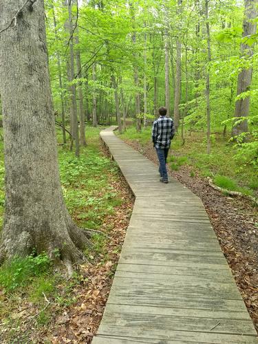
About this event
hilly. We’ll begin at Bull Run Regional Park
The hike will begin at 10:00 am and go about 7 miles (we’ll walk 3.5 miles and then turn back to our starting point). Bring water, sturdy shoes and some snacks.
For those in the Richmond area, we’ll have breakfast at McLean’s at 7:00 a.m. before leaving at 7:45 a.m. for the drive up.
https://www.novaparks.com/parks/bull-run-occoquan-trail
History of park:
The stream valley was originally inhabited by the Indians of Taux or Doag group of the Powhatan Confederacy, who rapidly succumbed to the advance of European settle-ment. Their word “Occoquan” means “at the end of the water.” Early English colonists gave Bull Run its name, applying the name “rundle” or “run” to streams not affected by tide and thereby running in one direction. Both native and colonial Americans depended on the area for food, materials for shelter and easy transportation on the water.
During the Civil War (1861-1865), Bull Run was a strategic defense line between the north and south and was the site of two major battles, First and Second Manassas (or Bull Run). On July 18, 1861 at Blackburns Ford (near present day Route 28) a skirmish occurred preliminary to the first Battle of Manassas. Federal troops attempting to secure the crossing were driven back by Confederates under General James Longstreet.
Many earthen forts were constructed to guard strategic crossings along Bull Run. A fine example can be easily seen just above where Little Rocky Run joins Bull Run.
The railroad bridge near Popes Head Creek was destroyed several times to prevent an en-emy’s control of the rails between Richmond and Washington. Evidence of the bridge and other fortifications may be seen along or near the Bull Run Occoquan Trail.
Directions to the trailhead
Get directionsBreakfast at McLean's, 3205 W Broad St, Richmond, VA 23230
Use your GPS for Bull Run Regional Park, 7700 Bull Run Dr, Centreville, VA 20121. I’ll be in a burgundy 2018 Honda Ridgeline. Drive towards the back of the park for the trail head.
Who's going (2)
 GUEST MEMBER
  GUEST MEMBER
 Questions about this event?
Questions for the host, TrailGuyEric, about route details, carpooling, or what to bring? Ask in the event discussion below.
Event discussion
No comments yet.
Log in to join the conversation.