
Mt. Robert Hike
Open ledges that provide grand views of Lake Winnipesaukee and summit has views of the White Mountains!
Mt. Robert Hike
Open ledges that provide grand views of Lake Winnipesaukee and summit has views of the White Mountains!
Details
Open ledges that provide grand views of Lake Winnipesaukee and summit has views of the White Mountains! This hike is in the Castle in the Clouds Conservation area that is managed by the Lakes Region Conservation Trust.
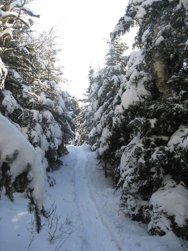
We will hike the Mt. Roberts Trail for 2.5 miles to the summit. We will return via the same route. We will hike fast enough to stay warm but not sweat.
MUST have MicroSpikes, winter insulated boots, hat, mittens/gloves and winter clothing [NO COTTON]. Snowshoes may be needed if there was a recent snowstorm...we'll let you know. Dress in layers of moisture-wicking clothing. A thermos of hot beverage is nice at the top and hand wamers for your gloves. Ask questions if you're not sure of what to wear.
Directions
FROM THE SOUTH
Take Rt. 93 N to Exit 23 [New Hampton/Meredith]. Take a right at the end of the ramp onto NH Rt. 104 toward Meredith. At the ned of that road take a left onto Rt. 3 and head toward Meredith, then take a right onto Route 25. Follow to the intersection of NH 109 and take a right on 109 towards Melvin Village. Stay left on NH 171 then take a left onto Ossipee Park road, [not Ossipee Mountain Road].
FROM THE EAST
From Route 16 in Ossipee take Route 28 south and then turn right onto Route 171 west. After about 15 miles on Route 171, you'll reach the Lower Trailhead on your left. Continue on Route 171 past the main Castle in the Clouds entrance 1 additional mile to Ossipee Park Road on the right to reach the Upper Trailhead.
Travel about 1 mile Ossipee Park Road, you will pass a stone gatehouse on your left, continue to the parking lot at the end on your right. We'll be driving a blue Toyota Tacoma truck.
About this event
Open ledges that provide grand views of Lake Winnipesaukee and summit has views of the White Mountains! This hike is in the Castle in the Clouds Conservation area that is managed by the Lakes Region Conservation Trust.
We will hike the Mt. Roberts Trail for 2.5 miles to the summit. We will return via the same route. We will hike fast enough to stay warm but not sweat.
MUST have MicroSpikes, winter insulated boots, hat, mittens/gloves and winter clothing [NO COTTON]. Snowshoes may be needed if there was a recent snowstorm...we'll let you know. Dress in layers of moisture-wicking clothing. A thermos of hot beverage is nice at the top and hand wamers for your gloves. Ask questions if you're not sure of what to wear.
Directions to the trailhead
Get directionsFROM THE SOUTH
Take Rt. 93 N to Exit 23 [New Hampton/Meredith]. Take a right at the end of the ramp onto NH Rt. 104 toward Meredith. At the ned of that road take a left onto Rt. 3 and head toward Meredith, then take a right onto Route 25. Follow to the intersection of NH 109 and take a right on 109 towards Melvin Village. Stay left on NH 171 then take a left onto Ossipee Park road, [not Ossipee Mountain Road].
FROM THE EAST
From Route 16 in Ossipee take Route 28 south and then turn right onto Route 171 west. After about 15 miles on Route 171, you'll reach the Lower Trailhead on your left. Continue on Route 171 past the main Castle in the Clouds entrance 1 additional mile to Ossipee Park Road on the right to reach the Upper Trailhead.
Travel about 1 mile Ossipee Park Road, you will pass a stone gatehouse on your left, continue to the parking lot at the end on your right. We'll be driving a blue Toyota Tacoma truck.
Who's going (7)





Questions about this event?
Reach out to the host, Gandalf, for route details, carpooling, or what to bring.
Email the hostYou can also ask in the event discussion below.
Event discussion
No comments yet.
Log in to join the conversation.