
Tripyramids Loop Hike
A Loop Hike Over the Tripyramids via the Famous Slides.
Tripyramids Loop Hike
A Loop Hike Over the Tripyramids via the Famous Slides.
Details
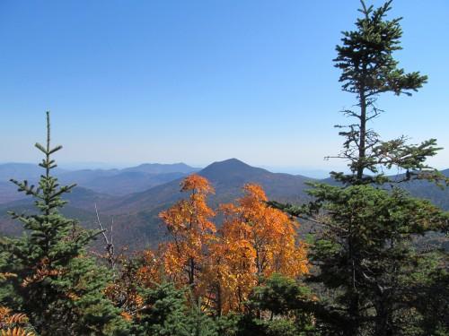
Join me on this classic 11-mile loop that tags the summit of all three Tripyramids - North (4180'), Middle (4140') and South (4100') - only two of which count on the 4000-footer list. The Tripyramids are best known for their slides...exposed slabs of rock and talus/scree that are visible from long distances, offering great views while hiking, and make for a unique trail experience. The north slide was formed by heavy rain in 1885, and the south slide was formed in 1869. The loop begins with the gentle and wide Livermore Trail. At 2.6 miles there is an intersection for the south end of Mount Tripyramid Trail. We will continue on the Livermore Trail for one additional mile to the north end of the Mount Tripyramid Trail. There, the real hiking begins, ascending a steep, rocky, and mostly exposed 1.2 miles to the summit of North Tripyramid. From this summit, the final 3.7 miles of the Mount Tripyramid trail tags the remaining two summits, descends another rocky slide below the south summit, and finally links back to the Livermore Trail at the southern end.
NOTE: Portions of this hike are STEEP with loose rock for footing. It will require use of your hands for climbing in a few spots.
Total Distance and Elevation Gain: 11 miles with approximately 2600 feet in accumulative elevation gain.
Total Time: Approximately 7 hours depending on breaks and group's speed.
Harsh weather may postpone to another date or cancel, as appropriate.
What to Bring: Typical late summer/fall hiking gear should be appropriate: convertible hiking pants or shorts, good sturdy hiking boots with thick socks, extra layer(s) (as needed) and a windbreaker/raingear (just in case). Also bring along lunch, snacks and plenty of water (at least 2-L). Optionally, pack bug repellent and sunscreen and anything else that you may require for a day hike.
Afterwards: We should be completed with the hike by 4-5PM. If there is sufficient interest, we'll cap the day off with a light dinner/drinks in Campton.
Directions
The parking area for the Livermore Road Trailhead can be reached off of West Branch Road near Tripoli Road. From Exit 28 of I-93, take NH Route 49 NE for about 13 miles. At the entrance to the Waterville Valley complex, turn LEFT on the Mount Tecumseh ski area access road (Tripoli Road), fork RIGHT at 1.2 miles to stay on Tripoli Road, after another 0.6 miles turn RIGHT on West Branch Road. Just across the bridge, turn LEFT on Livermore Road and immediately turn LEFT into the parking lot. Look for a grey Hyundai Elantra.
For GPS Users: 43.965843, -71.513894.
About this event
Join me on this classic 11-mile loop that tags the summit of all three Tripyramids - North (4180'), Middle (4140') and South (4100') - only two of which count on the 4000-footer list. The Tripyramids are best known for their slides...exposed slabs of rock and talus/scree that are visible from long distances, offering great views while hiking, and make for a unique trail experience. The north slide was formed by heavy rain in 1885, and the south slide was formed in 1869. The loop begins with the gentle and wide Livermore Trail. At 2.6 miles there is an intersection for the south end of Mount Tripyramid Trail. We will continue on the Livermore Trail for one additional mile to the north end of the Mount Tripyramid Trail. There, the real hiking begins, ascending a steep, rocky, and mostly exposed 1.2 miles to the summit of North Tripyramid. From this summit, the final 3.7 miles of the Mount Tripyramid trail tags the remaining two summits, descends another rocky slide below the south summit, and finally links back to the Livermore Trail at the southern end.
NOTE: Portions of this hike are STEEP with loose rock for footing. It will require use of your hands for climbing in a few spots.
Total Distance and Elevation Gain: 11 miles with approximately 2600 feet in accumulative elevation gain.
Total Time: Approximately 7 hours depending on breaks and group's speed.
Harsh weather may postpone to another date or cancel, as appropriate.
What to Bring: Typical late summer/fall hiking gear should be appropriate: convertible hiking pants or shorts, good sturdy hiking boots with thick socks, extra layer(s) (as needed) and a windbreaker/raingear (just in case). Also bring along lunch, snacks and plenty of water (at least 2-L). Optionally, pack bug repellent and sunscreen and anything else that you may require for a day hike.
Afterwards: We should be completed with the hike by 4-5PM. If there is sufficient interest, we'll cap the day off with a light dinner/drinks in Campton.
Directions to the trailhead
Get directionsThe parking area for the Livermore Road Trailhead can be reached off of West Branch Road near Tripoli Road. From Exit 28 of I-93, take NH Route 49 NE for about 13 miles. At the entrance to the Waterville Valley complex, turn LEFT on the Mount Tecumseh ski area access road (Tripoli Road), fork RIGHT at 1.2 miles to stay on Tripoli Road, after another 0.6 miles turn RIGHT on West Branch Road. Just across the bridge, turn LEFT on Livermore Road and immediately turn LEFT into the parking lot. Look for a grey Hyundai Elantra.
For GPS Users: 43.965843, -71.513894.
Who's going (4)

Questions about this event?
Reach out to the host, shep5, for route details, carpooling, or what to bring.
Email the hostYou can also ask in the event discussion below.
Event discussion
No comments yet.
Log in to join the conversation.