
Mt. Cube Hike
Great directional views from two open ledges, north and south peaks!
Mt. Cube Hike
Great directional views from two open ledges, north and south peaks!
Details
We will hike the Mt. Cube Trail [Appalachian Trail] to the summit of Mt. Cube, elevation 2,909 feet. Great directional views from two open ledges, north and south peaks!
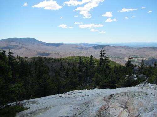
Mount Cube, with open ledges on its north and south peaks, commands views both back down the valley towards Hanover and ahead to Mount Moosilauke and the White Mountains beyond. This is the northern end of the long ridge stretching north from South Moose Mountain that forms the eastern edge of the Connecticut River valley. The pinkish-gray summit rocks are quartzite, the same hard ridge-forming rock that runs in a band from Lebanon, over Moose, up Lambert Ridge, and on to Cube. On warm days, the summit ledges of Mount Cube are excellent lunch spots!
At 1.6 miles, after cresting a small rise, the trail winds down to cross Brackett Brook that can be tricky during high water or if not snow bridged. At 2.8 miles, the trail crests the shoulder and climbs gently towards the summit ridge. At 3.1 miles, arrive at a T-junction between north and south summits. To the right, the blue-blazed side trail leads in 0.2 miles to the north summit, with its fine view of Moosilauke. To the left, the AT continues south. at 3.3 miles, reach the south summit of Mount Cube. Smarts and Ascutney dominate a view that covers much of the Upper Valley of the Connecticut. Follow the same trail you came up to return to your car.
Book time: 4 hours
6.8 miles round trip
2,200 feet Elevation Gain
What to Bring: Bring MicroSpikes since there will still be snow on the ground. The snow could be soft due to warmer temperatures so have snowshoes in your car ready to strap on to your pack in case we need them. Wear winter insulated boots to keep your feet warm in the snow. Dress in layers including gloves and a warm hat. Have a daypack bigger than your summer one so you can put your clothes into it as you warm up. Bring water, lunch and snacks.
Directions
I-93 Exit 26
NH-25 west [for 15.7 miles]
NH-25A west [for 4.6 miles]
Parking at trailhead along left side of road, just after small bridge over Pond Brook. Trailhead on same side as parking, marked by Dartmouth Outing Club sign. Note that there's a hiker sign on right before the bridge and old logging road on left after the bridge that looks like the trail, but it's not. Trailhead is a little farther down the road, at end of parking area if coming from I-93 direction. We will be driving a blue Toyota FJ Cruiser.
About this event
We will hike the Mt. Cube Trail [Appalachian Trail] to the summit of Mt. Cube, elevation 2,909 feet. Great directional views from two open ledges, north and south peaks!
Mount Cube, with open ledges on its north and south peaks, commands views both back down the valley towards Hanover and ahead to Mount Moosilauke and the White Mountains beyond. This is the northern end of the long ridge stretching north from South Moose Mountain that forms the eastern edge of the Connecticut River valley. The pinkish-gray summit rocks are quartzite, the same hard ridge-forming rock that runs in a band from Lebanon, over Moose, up Lambert Ridge, and on to Cube. On warm days, the summit ledges of Mount Cube are excellent lunch spots!
At 1.6 miles, after cresting a small rise, the trail winds down to cross Brackett Brook that can be tricky during high water or if not snow bridged. At 2.8 miles, the trail crests the shoulder and climbs gently towards the summit ridge. At 3.1 miles, arrive at a T-junction between north and south summits. To the right, the blue-blazed side trail leads in 0.2 miles to the north summit, with its fine view of Moosilauke. To the left, the AT continues south. at 3.3 miles, reach the south summit of Mount Cube. Smarts and Ascutney dominate a view that covers much of the Upper Valley of the Connecticut. Follow the same trail you came up to return to your car.
Book time: 4 hours
6.8 miles round trip
2,200 feet Elevation Gain
What to Bring: Bring MicroSpikes since there will still be snow on the ground. The snow could be soft due to warmer temperatures so have snowshoes in your car ready to strap on to your pack in case we need them. Wear winter insulated boots to keep your feet warm in the snow. Dress in layers including gloves and a warm hat. Have a daypack bigger than your summer one so you can put your clothes into it as you warm up. Bring water, lunch and snacks.
Directions to the trailhead
Get directionsI-93 Exit 26
NH-25 west [for 15.7 miles]
NH-25A west [for 4.6 miles]
Parking at trailhead along left side of road, just after small bridge over Pond Brook. Trailhead on same side as parking, marked by Dartmouth Outing Club sign. Note that there's a hiker sign on right before the bridge and old logging road on left after the bridge that looks like the trail, but it's not. Trailhead is a little farther down the road, at end of parking area if coming from I-93 direction. We will be driving a blue Toyota FJ Cruiser.
Who's going (11)





Questions about this event?
Reach out to the host, Gandalf, for route details, carpooling, or what to bring.
Email the hostYou can also ask in the event discussion below.
Event discussion
No comments yet.
Log in to join the conversation.