
Get Hike Hike#3:Mts. Monroe and Franklin
Third of five hikes that progressively get harder leading up to Mt. Washington!
Get Hike Hike#3:Mts. Monroe and Franklin
Third of five hikes that progressively get harder leading up to Mt. Washington!
Details
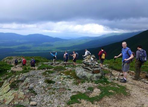
Mt. Monroe, [5,372'] is an excellent alternative to its more famous neighbor, Mt. Washington, offering superb views! The highest of the Southern Presidentials, it provides a wonderful craggy throne for gazing at Oakes Gulf and the Dry River valley, down the twisting Southern Presidential ridge, and up to massive Mt. Washington with the Lakes of the Clouds nestled beneath. We will ascend up the Ammonoosuc Ravine Trail with a stop at Lake of the Clouds and the AMC hut.
We'll then hike the Crawford Path to the Mount Monroe Loop. Continue to enjoy the magnificent open ridge walk overr to Mt. Franklin
We will car spot, so we can enjoy the magnificent open ridge walk over Mt. Franklin [5,001'] on the Crawford Path, a little alpine bump, that has an interesting view looking down into the Dry River valley from the brink. We'll descend via the Edmands Path. This is considered a moderate to strenuous hike!!! Proper gear is must.
On the Ammonoosuc Ravine Trail, there is a very steep, rough ascent. Email us if you have any questions. The loop is 8.2 miles, 2,950 feet elevation gain and a book time of 5 1/2 hours. It always takes us longer so plan on a finish of 5 pm.
After The Hike: Everyone is welcome back at our house in Waterville Valley to socialize around the deck and enjoy a home cooked meal with dessert! It's BYOB and it costs $5 per person.
Lodging Option: Bunk beds are available at our house near Waterville Valley, NH for Friday and/or Saturday night at $20 per night. Coffee/bagels each morning and linen/blankets/towels are provided. We have limited space in the fridge to store your beverages/food so it's best to bring a small cooler. Space is limited so email ASAP to reserve a bunk!
Directions
We are meeting at the Edmands Path trailhead, drop some cars off and CARPOOL at the start: Ammonoosuc Ravine trailhead. To reach the Edmands Path, turn off US 302 at Fabyan onto the Base Road leading to the cog railway's base station. Soon Mt. Washington and Mt. Monroe comes into sight. Drive on the Base Road about 5 miles to an intersection. Turn right. You are now on the Mount Clinton Road. Drive 1.5 miles from the four corners. And drive carefully; there's a startling 90-degree curve around 0.5 miles before the trailhead. The parking area is on the left. It fills up quickly so we may have to park along the road.
About this event
Mt. Monroe, [5,372'] is an excellent alternative to its more famous neighbor, Mt. Washington, offering superb views! The highest of the Southern Presidentials, it provides a wonderful craggy throne for gazing at Oakes Gulf and the Dry River valley, down the twisting Southern Presidential ridge, and up to massive Mt. Washington with the Lakes of the Clouds nestled beneath. We will ascend up the Ammonoosuc Ravine Trail with a stop at Lake of the Clouds and the AMC hut.
We'll then hike the Crawford Path to the Mount Monroe Loop. Continue to enjoy the magnificent open ridge walk overr to Mt. Franklin
We will car spot, so we can enjoy the magnificent open ridge walk over Mt. Franklin [5,001'] on the Crawford Path, a little alpine bump, that has an interesting view looking down into the Dry River valley from the brink. We'll descend via the Edmands Path. This is considered a moderate to strenuous hike!!! Proper gear is must.
On the Ammonoosuc Ravine Trail, there is a very steep, rough ascent. Email us if you have any questions. The loop is 8.2 miles, 2,950 feet elevation gain and a book time of 5 1/2 hours. It always takes us longer so plan on a finish of 5 pm.
After The Hike: Everyone is welcome back at our house in Waterville Valley to socialize around the deck and enjoy a home cooked meal with dessert! It's BYOB and it costs $5 per person.
Lodging Option: Bunk beds are available at our house near Waterville Valley, NH for Friday and/or Saturday night at $20 per night. Coffee/bagels each morning and linen/blankets/towels are provided. We have limited space in the fridge to store your beverages/food so it's best to bring a small cooler. Space is limited so email ASAP to reserve a bunk!
Directions to the trailhead
Get directionsWe are meeting at the Edmands Path trailhead, drop some cars off and CARPOOL at the start: Ammonoosuc Ravine trailhead. To reach the Edmands Path, turn off US 302 at Fabyan onto the Base Road leading to the cog railway's base station. Soon Mt. Washington and Mt. Monroe comes into sight. Drive on the Base Road about 5 miles to an intersection. Turn right. You are now on the Mount Clinton Road. Drive 1.5 miles from the four corners. And drive carefully; there's a startling 90-degree curve around 0.5 miles before the trailhead. The parking area is on the left. It fills up quickly so we may have to park along the road.
Who's going (8)
 SUSTAINING
  SUSTAINING
  GUEST MEMBER
  GUEST MEMBER
  GUEST MEMBER
  GUEST MEMBER
  GUEST MEMBER
 Questions about this event?
Reach out to the host, Gandalf, for route details, carpooling, or what to bring.
Email the hostYou can also ask in the event discussion below.
Event discussion
Log in to join the conversation.