
Mts Washington & Monroe Loop Hike
A Loop Hike over the Northeast's Highest Peak...Mt. Washington.
Mts Washington & Monroe Loop Hike
A Loop Hike over the Northeast's Highest Peak...Mt. Washington.
Details
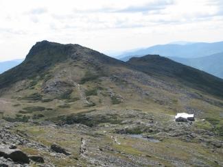
Join me for this classic loop hike over the highest point in the Northeast. On our way up to Mt. Washington (6288') we will utilize the Jewell and Gulfside Trails. This is modest in grade, but the trails are rocky above treeline. Our descent off of Washington will use the Crawford Path down to Lake of the Clouds. Here we'll take the short trip up and back to Mount Monroe (5372') before descending the Ammonoosuc Ravine Trail. Much of this trip is above treeline, so we'll be exposed for a good portion of the day...but on a clear day the views are expansive. Expect cold temperatures and wind, particularly on the summits.
Total Distance and Elevation Gain: 9.5 miles with approximately 4000 feet in accumulative elevation gain.
Total Time: 8 hours or more depending on breaks and group's speed.
Rain or harsh summit weather may postpone to another date or cancel, as appropriate.
What to Bring: Typical fall hiking gear should be appropriate: convertible hiking pants, good sturdy hiking boots with thick socks, a windbreaker/raingear and extra layers (e.g. fleece)...or winter jacket/parka depending on forecasted summit conditions. Also bring along lunch, snacks and plenty of water (at least 2-L). Optionally, pack sunscreen and anything else that you may require for a day hike.
Carpooling: Contact other participants or the trip leader to arrange for a rideshare to the trailhead.
Afterwards: If there is sufficient interest, we will have drinks and/or dinner in the area (Fabyans).
Directions
From the intersection of Rts. 3 and 302 in Twin Mountain, take Route 302 east for 4.4 miles. Just past Fabyan's Restaurant, turn left onto Base Station Road (there is a billboard for the Cog Railway here). Take Base Station Road for 6.0 miles. Hikers must use the lower lot at the Cog Railway Station...it is marked. Look for a grey Hyundai Elantra.
For GPS Users: Mount Washington Cog Railway, Base Station Road, Bretton Woods, NH (44.268344,-71.353081).
About this event
Join me for this classic loop hike over the highest point in the Northeast. On our way up to Mt. Washington (6288') we will utilize the Jewell and Gulfside Trails. This is modest in grade, but the trails are rocky above treeline. Our descent off of Washington will use the Crawford Path down to Lake of the Clouds. Here we'll take the short trip up and back to Mount Monroe (5372') before descending the Ammonoosuc Ravine Trail. Much of this trip is above treeline, so we'll be exposed for a good portion of the day...but on a clear day the views are expansive. Expect cold temperatures and wind, particularly on the summits.
Total Distance and Elevation Gain: 9.5 miles with approximately 4000 feet in accumulative elevation gain.
Total Time: 8 hours or more depending on breaks and group's speed.
Rain or harsh summit weather may postpone to another date or cancel, as appropriate.
What to Bring: Typical fall hiking gear should be appropriate: convertible hiking pants, good sturdy hiking boots with thick socks, a windbreaker/raingear and extra layers (e.g. fleece)...or winter jacket/parka depending on forecasted summit conditions. Also bring along lunch, snacks and plenty of water (at least 2-L). Optionally, pack sunscreen and anything else that you may require for a day hike.
Carpooling: Contact other participants or the trip leader to arrange for a rideshare to the trailhead.
Afterwards: If there is sufficient interest, we will have drinks and/or dinner in the area (Fabyans).
Directions to the trailhead
Get directionsFrom the intersection of Rts. 3 and 302 in Twin Mountain, take Route 302 east for 4.4 miles. Just past Fabyan's Restaurant, turn left onto Base Station Road (there is a billboard for the Cog Railway here). Take Base Station Road for 6.0 miles. Hikers must use the lower lot at the Cog Railway Station...it is marked. Look for a grey Hyundai Elantra.
For GPS Users: Mount Washington Cog Railway, Base Station Road, Bretton Woods, NH (44.268344,-71.353081).
Who's going (2)


Questions about this event?
Reach out to the host, shep5, for route details, carpooling, or what to bring.
Email the hostYou can also ask in the event discussion below.
Event discussion
Log in to join the conversation.