
Mt. Cabot Snowshoe
<p>A western approach to this 4,000 footer with good views from the cabin and old firetower site.</p>
Mt. Cabot Snowshoe
<p>A western approach to this 4,000 footer with good views from the cabin and old firetower site.</p>
Details
A western approach to this 4,000 footer with good views from the cabin and old firetower site.
Over three hours from Boston, we'll be climbing up the most northern 4,000 footer.
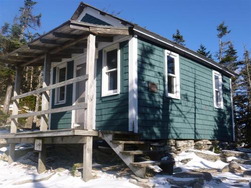
Mt. Cabot has a nice cabin to protect ourselves from the elements while having lunch and taking in the lovely views.
Terrain: The first 2.2 miles is an easy, graded terrain. Afterwards the crux of the climb begins with a fairly steep and unforgiving climb. Since we will begin using an 'unofficial' trail we are quite certain we'll be breaking trail. Everyone is required to have snowshoes. You can reserve and rent snowshoes from your local outdoor outfitter such as REI, EMS, or from Ski Fanatics off Exit 28 on I-93.
Trail: This is an up and back hike using an unofficial trail [former Mt. Cabot Trail] that starts off with following an old logging road for 2.2 miles. After we cross Bunnell Brook, we'll then reach the 'official' Mt. Cabot Trail that takes us to the Kilkenny Ridge Trail leading us to the summit. Along the ascent we'll check out Bunnell Rock, a ledge at the cliff-top that offers an excellent vista to the south ~ probably the best view on the trail.
Time/Distance: Hike time is approximately 7 hours. Round trip distance is 8 miles with 2,700 ft. elevation gain. We will take our time to enjoy the views, eat lunch, take pictures and have fun!
Gear List: Be sure to bring appropriate winter gear such as winter insulated boots, traction (micropikes, crampons, etc.), snowshoes (we have some to borrow so let us know), warm clothing (no cotton and blue jeans), water, lunch and snacks, etc.
After The Hike: Everyone is welcome back at our house in Waterville Valley to socialize around the fireplace and enjoy a home cooked meal with dessert! It's BYOB and it costs $5 per person.
Lodging Option: Bunk beds are available at my house near Waterville Valley, NH for Friday and/or Saturday night for $20 per night. Coffee/bagels each morning and linen/blankets/towels are provided. We have limited space in the fridge to store your beverages/food so it's best to bring a small cooler. Space is limited so email me ASAP to reserve a bunk!
Carpooling: Contact other guys living near you for carpooling. If you are driving up I-93, meet Jon and I off the Exit 28 ramp at the Post Office parking lot for 7:45 A.M.
Directions
Take I-93 North, Route 3 North, and Route 115 North. At the junction of US 2, take a left and follow west. Follow and look for the junction of US 2 and NH 116 just west of the village of Jefferson [gas station here at this junction]. In 0.2 mile after this junction turn right [north] on North Road and follow for 2.3 miles. Turn right again on Gore Road [which become Garland Road at a very sharp left turn]. At 4.0 miles from US 2, turn right again on Pleasant Valley Road, and at 4,8 miles turn right on Arthur White Road. Continue 0.4 mile up this road to an 'unsigned' parking area [may not be plowed] about 50 yards before a beautiful house on the left. Do not block the gate or the driveway. We'll be driving a blue Toyota FJ Cruiser.
About this event
A western approach to this 4,000 footer with good views from the cabin and old firetower site.
Over three hours from Boston, we'll be climbing up the most northern 4,000 footer.
Mt. Cabot has a nice cabin to protect ourselves from the elements while having lunch and taking in the lovely views.
Terrain: The first 2.2 miles is an easy, graded terrain. Afterwards the crux of the climb begins with a fairly steep and unforgiving climb. Since we will begin using an 'unofficial' trail we are quite certain we'll be breaking trail. Everyone is required to have snowshoes. You can reserve and rent snowshoes from your local outdoor outfitter such as REI, EMS, or from Ski Fanatics off Exit 28 on I-93.
Trail: This is an up and back hike using an unofficial trail [former Mt. Cabot Trail] that starts off with following an old logging road for 2.2 miles. After we cross Bunnell Brook, we'll then reach the 'official' Mt. Cabot Trail that takes us to the Kilkenny Ridge Trail leading us to the summit. Along the ascent we'll check out Bunnell Rock, a ledge at the cliff-top that offers an excellent vista to the south ~ probably the best view on the trail.
Time/Distance: Hike time is approximately 7 hours. Round trip distance is 8 miles with 2,700 ft. elevation gain. We will take our time to enjoy the views, eat lunch, take pictures and have fun!
Gear List: Be sure to bring appropriate winter gear such as winter insulated boots, traction (micropikes, crampons, etc.), snowshoes (we have some to borrow so let us know), warm clothing (no cotton and blue jeans), water, lunch and snacks, etc.
After The Hike: Everyone is welcome back at our house in Waterville Valley to socialize around the fireplace and enjoy a home cooked meal with dessert! It's BYOB and it costs $5 per person.
Lodging Option: Bunk beds are available at my house near Waterville Valley, NH for Friday and/or Saturday night for $20 per night. Coffee/bagels each morning and linen/blankets/towels are provided. We have limited space in the fridge to store your beverages/food so it's best to bring a small cooler. Space is limited so email me ASAP to reserve a bunk!
Carpooling: Contact other guys living near you for carpooling. If you are driving up I-93, meet Jon and I off the Exit 28 ramp at the Post Office parking lot for 7:45 A.M.
Directions to the trailhead
Get directionsTake I-93 North, Route 3 North, and Route 115 North. At the junction of US 2, take a left and follow west. Follow and look for the junction of US 2 and NH 116 just west of the village of Jefferson [gas station here at this junction]. In 0.2 mile after this junction turn right [north] on North Road and follow for 2.3 miles. Turn right again on Gore Road [which become Garland Road at a very sharp left turn]. At 4.0 miles from US 2, turn right again on Pleasant Valley Road, and at 4,8 miles turn right on Arthur White Road. Continue 0.4 mile up this road to an 'unsigned' parking area [may not be plowed] about 50 yards before a beautiful house on the left. Do not block the gate or the driveway. We'll be driving a blue Toyota FJ Cruiser.
Who's going (2)
 SUSTAINING
 SUSTAINING
Questions about this event?
Reach out to the host, Gandalf, for route details, carpooling, or what to bring.
Email the hostYou can also ask in the event discussion below.
Event discussion
Log in to join the conversation.