
Percy Peaks Loop Hike
A Hike to Two Lesser Visited Peaks North of the Whites...The beautiful, twin Percy Peaks!
Percy Peaks Loop Hike
A Hike to Two Lesser Visited Peaks North of the Whites...The beautiful, twin Percy Peaks!
Details
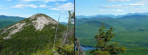
The Percy Peaks are beautiful, twin peaks located north of the White Mountains in the Nash Stream Forest, just north of Stark, NH. The Nash Stream Forest is a parcel of 39,601 acres located in Coos County in northern New Hampshire. It is one of NH's largest protected forests. Its remote location and many natural features, such as ponds, streams, mountain peaks, and forest land, contribute to its natural beauty and ecological value. The peaks (North Percy Peak 3430' / South Percy Peak 3224') have wonderful views into the surrounding wilderness as well as south to the White Mountains. We'll visit the summits of the two peaks as a loop hike...ascending via the Percy Peaks Trail and descending via the Percy Loop (a short road walk will be required to get back to our cars.
Total Distance and Elevation Gain: About 6.5 miles with approximately 2650 feet in elevation gain.
Total Time: 5.0 to 6.5 hours depending on breaks and group's speed.
What to Wear/Bring: Boots with good traction are required, as the granite is steep and smooth on the way to the summit. Also bring along lunch, snacks and plenty of water.
Directions
PS: directions copied from prior posting
FROM THE WEST: From the junction of Routes 3 and 110 in Groveton, drive 2.6 miles east along Route 110. Turn left onto Emerson Road and travel 1.4 miles. This turns into Northside Road. Continue following this road for 0.7 miles. Turn left onto Nash Stream Road and follow for about 2 miles to the marked parking area. The parking area is relatively small and is just prior to the trailhead (by about 50 feet). The parking area should be on the right within view of the Slide Brook.
FROM THE EAST: From the junction of Routes 16 and 110 in Berlin, drive 18 miles west along Route 110. Turn right onto Northside Road and follow for 3.5 miles until you reach Nash Stream Road. Follow Nash Stream Road for about 2 miles to the trailhead parking area. Look for a gray Hyundai Elantra.
For GPS Users: 44.656533, -71.463131 (Nash Stream Rd, Stratford, NH)
About this event
The Percy Peaks are beautiful, twin peaks located north of the White Mountains in the Nash Stream Forest, just north of Stark, NH. The Nash Stream Forest is a parcel of 39,601 acres located in Coos County in northern New Hampshire. It is one of NH's largest protected forests. Its remote location and many natural features, such as ponds, streams, mountain peaks, and forest land, contribute to its natural beauty and ecological value. The peaks (North Percy Peak 3430' / South Percy Peak 3224') have wonderful views into the surrounding wilderness as well as south to the White Mountains. We'll visit the summits of the two peaks as a loop hike...ascending via the Percy Peaks Trail and descending via the Percy Loop (a short road walk will be required to get back to our cars.
Total Distance and Elevation Gain: About 6.5 miles with approximately 2650 feet in elevation gain.
Total Time: 5.0 to 6.5 hours depending on breaks and group's speed.
What to Wear/Bring: Boots with good traction are required, as the granite is steep and smooth on the way to the summit. Also bring along lunch, snacks and plenty of water.
Directions to the trailhead
Get directionsPS: directions copied from prior posting
FROM THE WEST: From the junction of Routes 3 and 110 in Groveton, drive 2.6 miles east along Route 110. Turn left onto Emerson Road and travel 1.4 miles. This turns into Northside Road. Continue following this road for 0.7 miles. Turn left onto Nash Stream Road and follow for about 2 miles to the marked parking area. The parking area is relatively small and is just prior to the trailhead (by about 50 feet). The parking area should be on the right within view of the Slide Brook.
FROM THE EAST: From the junction of Routes 16 and 110 in Berlin, drive 18 miles west along Route 110. Turn right onto Northside Road and follow for 3.5 miles until you reach Nash Stream Road. Follow Nash Stream Road for about 2 miles to the trailhead parking area. Look for a gray Hyundai Elantra.
For GPS Users: 44.656533, -71.463131 (Nash Stream Rd, Stratford, NH)
Who's going (2)


Questions about this event?
Reach out to the host, baezfred, for route details, carpooling, or what to bring.
Email the hostYou can also ask in the event discussion below.
Event discussion
No comments yet.
Log in to join the conversation.