
Mt. Chocorua Loop Hike
A Loop Hike over the Carter Ledges, The Three Sisters and Mt. Chocorua.
Mt. Chocorua Loop Hike
A Loop Hike over the Carter Ledges, The Three Sisters and Mt. Chocorua.
Details
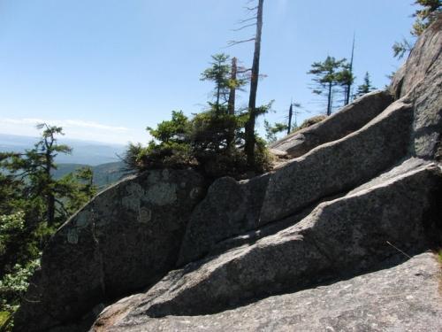
Join me for this 9.3 mile loop hike, which will encompass the teep Carter Ledges, the Three Sisters and the summit of Mount Chocorua. While not a 4000-footer, Mount Chocorua has the feel of one. It is very rugged and has excellent 360-degree views of the surrounding lakes, mountains, and forests. Mount Chocorua's distinctive, bare summit can be seen from almost every direction and can be identified from many points throughout central New Hampshire and western Maine. The hike will ascend via the Piper and Carter Ledge Trails to the Carter Ledge and the Three Sisters (subpeaks). After ascending the summit, we'll return by way of the Liberty, Hammond, Weetsmoo Trails back down to the Piper Trail. There are lots of spectacular views along this route!
NOTE: If you are uncomfortable with heights and a steep drop-off, this might not be the best hike for you. Appropriate hiking boots with good traction are a must!
Total Distance and Elevation Gain: 9.3 miles with approximately 2800 feet in cumulative elevation gain.
Total Time: 6-7.5 hours depending on breaks and group's speed.
Rain or harsh weather may postpone to another date or cancel, as appropriate.
What to Bring: Typical summer hiking gear should be appropriate: convertible hiking pants, good sturdy hiking boots, sunscreen, bug spray, a windbreaker/raingear and extra layers. Also bring along lunch, snacks and plenty of water (at least 2-L).
Carpooling: Contact other participants or the trip leader to arrange for a rideshare to the trailhead.
Afterwards: If there is sufficient interest, we will have drinks and/or dinner in the area.
Directions
FROM POINTS SOUTH CONVENIENT TO ROUTE 93: Take Route 93 to Exit 23. Take Route 104 East for 8.2 miles. Turn onto Route 3 and follow for 0.9 miles to the intersection with Route 25. Take Route 25 for 19 miles and then turn onto Route 113 East. Follow NH 113 for 2.9 miles. Just after the village of Tamworth, turn right onto Page Hill Road. Follow this for 3 miles to Route 16 in Chocorua (NOTE: If you stay on NH 113, you'll get to the same point.). Take Route 16 North for 6 miles to the Davies Campground and General Store (on your left just before Moulton Drive).
FROM POINTS SOUTH CONVENIENT TO ROUTE 16: From Portsmouth, NH, drive Route 16 North for roughly 70.8 miles to the Davies Campground and General Store (see above).
The trailhead parking area is accessed by a dirt road off NH Rt 16 behind Davies Campground and General Store, 6.1 miles south of the juntion with the Kancamagus Hwy (Rt 112) in Conway. Look for a white Honda CRV.
Day fee for the parking lot (unless you have a sticker) is $5 cash. There are decent camping bathrooms at the parking lot.
For GPS Users: 43.939451, -71.225266 (approximate address 2509 NH Route 16; Albany, NH – at the intersection of Moulton Drive).
Meeting Time: 8:00 AM.
About this event
Join me for this 9.3 mile loop hike, which will encompass the teep Carter Ledges, the Three Sisters and the summit of Mount Chocorua. While not a 4000-footer, Mount Chocorua has the feel of one. It is very rugged and has excellent 360-degree views of the surrounding lakes, mountains, and forests. Mount Chocorua's distinctive, bare summit can be seen from almost every direction and can be identified from many points throughout central New Hampshire and western Maine. The hike will ascend via the Piper and Carter Ledge Trails to the Carter Ledge and the Three Sisters (subpeaks). After ascending the summit, we'll return by way of the Liberty, Hammond, Weetsmoo Trails back down to the Piper Trail. There are lots of spectacular views along this route!
NOTE: If you are uncomfortable with heights and a steep drop-off, this might not be the best hike for you. Appropriate hiking boots with good traction are a must!
Total Distance and Elevation Gain: 9.3 miles with approximately 2800 feet in cumulative elevation gain.
Total Time: 6-7.5 hours depending on breaks and group's speed.
Rain or harsh weather may postpone to another date or cancel, as appropriate.
What to Bring: Typical summer hiking gear should be appropriate: convertible hiking pants, good sturdy hiking boots, sunscreen, bug spray, a windbreaker/raingear and extra layers. Also bring along lunch, snacks and plenty of water (at least 2-L).
Carpooling: Contact other participants or the trip leader to arrange for a rideshare to the trailhead.
Afterwards: If there is sufficient interest, we will have drinks and/or dinner in the area.
Directions to the trailhead
Get directionsFROM POINTS SOUTH CONVENIENT TO ROUTE 93: Take Route 93 to Exit 23. Take Route 104 East for 8.2 miles. Turn onto Route 3 and follow for 0.9 miles to the intersection with Route 25. Take Route 25 for 19 miles and then turn onto Route 113 East. Follow NH 113 for 2.9 miles. Just after the village of Tamworth, turn right onto Page Hill Road. Follow this for 3 miles to Route 16 in Chocorua (NOTE: If you stay on NH 113, you'll get to the same point.). Take Route 16 North for 6 miles to the Davies Campground and General Store (on your left just before Moulton Drive).
FROM POINTS SOUTH CONVENIENT TO ROUTE 16: From Portsmouth, NH, drive Route 16 North for roughly 70.8 miles to the Davies Campground and General Store (see above).
The trailhead parking area is accessed by a dirt road off NH Rt 16 behind Davies Campground and General Store, 6.1 miles south of the juntion with the Kancamagus Hwy (Rt 112) in Conway. Look for a white Honda CRV.
Day fee for the parking lot (unless you have a sticker) is $5 cash. There are decent camping bathrooms at the parking lot.
For GPS Users: 43.939451, -71.225266 (approximate address 2509 NH Route 16; Albany, NH – at the intersection of Moulton Drive).
Meeting Time: 8:00 AM.
Who's going (7)

Questions about this event?
Log in to see who's hosting and to ask them questions in the event discussion.
Log in
Event discussion
Please let me know what I can bring towards the BBQ. Is there a grocery store nearby where I can grab something vegetarian on the way there from Chocorua?
from Marc: ”sounds great. I will be quick with food. Probably chicken, store bought salads corn, chips and something for desert. The pond is really nice and clothing optional. A great refresher after a hike. The beverage of one’s choice is the only thing to bring.
I recommend folks bring stuff in a cooler if they want. Carl, no nearby vegie places but I'll have both a vegie stuffed pepper and quiche and happy to share, give you either, etc.
I recommend folks bring stuff in a cooler if they want. Carl, no nearby vegie places but I'll have both a vegie stuffed pepper and quiche and happy to share, give you either, etc.
Log in to join the conversation.