
Mt. Madison Hike
This is a big hike, but should be a fun one. There will be plenty of time above treeline and no shortage of views!
Mt. Madison Hike
This is a big hike, but should be a fun one. There will be plenty of time above treeline and no shortage of views!
Details
This is a big hike, but should be a fun one. There will be plenty of time above treeline and no shortage of views! Madison [5,367 feet] is part of the northern Presidential Range ~ and among the tallest peaks in the northeast [#5]. Time permitting when we return back to the Mad River Lodge, we can cool off in the Mad River followed by a BBQ.
Stats
Difficulty: Very Strenuous
Distance: 8.2 miles
Elevation Gain: 4050 feet
Itinerary
Start: Appalachia Trailhead [Route 2]
Valley Way
Watson Path
Mt. Madison Summit [5,366 ft.]
Osgood Trail
Valley Way Trail
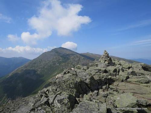
The Valley Way/Watson is one of the shortest routes to Madison, but is steep and rough for its upper 1.5 miles with a long stretch of above treeline travel. The open, rocky crest of Madison combines nearby views of Mt. Washington and Adams, the Great Gulf and the Carter Range where we'll have lunch. We'll then descend to Madison Spring Hut to refill our water bottles and return back to our vehicles down the Valleyy Way.
Due to the high elevation and level of exposure, we'll have to be particularly mindful of the weather forecast and adjust our plans if necessary.
Stuff To Bring:
- Non-cotton clothing [synthetics/wool]
- Layers
- Rain Gear
- Proper footwear [hiking shoes/boots]
- At least 2 liters of water [we'll get more water at the Hut]
- Sunscreen/Sunglasses
- Lunch/snacks
Afterwards: Everyone is welcome to join us back at our house in Waterville Valley to relax on our deck [BYOB and bring snacks] and a BBQ! We ask $10 per person to help pay for our food costs. Please let us know you will join us for the BBQ so we have enough food. Showers are available so bring a change of clothing to make your visit with us more comfortable.
Lodging Option: Bunk beds are available at our house [with Wi Fi] near Waterville Valley, NH for Friday and/or Saturday nights. It's $25 for Friday night, $35 for Saturday that includes dinner or $60 for the weekend. Coffee/bagels each morning and linen/blankets/towels are provided. Space is limited so email ASAP to reserve a bunk!
Directions
Follow New Hampshire Route 16 north thorough Pinkham Notch to the town of Gorham and turn left [west] on U.S. Highway 2. The large Appalachia Trailhead parking area is on the left [south] side of the highway about 6 miles west of Gorham. We'll be driving a blue Toyota Tacoma truck.
Or take I-93 North, then U.S Highway 3 North, and then New Hampshire Route 115. Turn right [east] on U.S. Highway 2 and drive about 12 miles [more or less] to the large Appalachia Trailhead parking area on the right [south] side of the highway. We'll be driving a blue Toyota Tacoma truck.
About this event
This is a big hike, but should be a fun one. There will be plenty of time above treeline and no shortage of views! Madison [5,367 feet] is part of the northern Presidential Range ~ and among the tallest peaks in the northeast [#5]. Time permitting when we return back to the Mad River Lodge, we can cool off in the Mad River followed by a BBQ.
Stats
Difficulty: Very Strenuous
Distance: 8.2 miles
Elevation Gain: 4050 feet
Itinerary
Start: Appalachia Trailhead [Route 2]
Valley Way
Watson Path
Mt. Madison Summit [5,366 ft.]
Osgood Trail
Valley Way Trail
The Valley Way/Watson is one of the shortest routes to Madison, but is steep and rough for its upper 1.5 miles with a long stretch of above treeline travel. The open, rocky crest of Madison combines nearby views of Mt. Washington and Adams, the Great Gulf and the Carter Range where we'll have lunch. We'll then descend to Madison Spring Hut to refill our water bottles and return back to our vehicles down the Valleyy Way.
Due to the high elevation and level of exposure, we'll have to be particularly mindful of the weather forecast and adjust our plans if necessary.
Stuff To Bring:
- Non-cotton clothing [synthetics/wool]
- Layers
- Rain Gear
- Proper footwear [hiking shoes/boots]
- At least 2 liters of water [we'll get more water at the Hut]
- Sunscreen/Sunglasses
- Lunch/snacks
Afterwards: Everyone is welcome to join us back at our house in Waterville Valley to relax on our deck [BYOB and bring snacks] and a BBQ! We ask $10 per person to help pay for our food costs. Please let us know you will join us for the BBQ so we have enough food. Showers are available so bring a change of clothing to make your visit with us more comfortable.
Lodging Option: Bunk beds are available at our house [with Wi Fi] near Waterville Valley, NH for Friday and/or Saturday nights. It's $25 for Friday night, $35 for Saturday that includes dinner or $60 for the weekend. Coffee/bagels each morning and linen/blankets/towels are provided. Space is limited so email ASAP to reserve a bunk!
Directions to the trailhead
Get directionsFollow New Hampshire Route 16 north thorough Pinkham Notch to the town of Gorham and turn left [west] on U.S. Highway 2. The large Appalachia Trailhead parking area is on the left [south] side of the highway about 6 miles west of Gorham. We'll be driving a blue Toyota Tacoma truck.
Or take I-93 North, then U.S Highway 3 North, and then New Hampshire Route 115. Turn right [east] on U.S. Highway 2 and drive about 12 miles [more or less] to the large Appalachia Trailhead parking area on the right [south] side of the highway. We'll be driving a blue Toyota Tacoma truck.
Who's going (9)


Questions about this event?
Reach out to the host, Gandalf, for route details, carpooling, or what to bring.
Email the hostYou can also ask in the event discussion below.
Event discussion
I will be able to take over leading the hike from Mike & Jon who will not be able to attend.
Hikers are invited to stay over at my house near Franconia, NH on Friday & Saturday nights or stop by after the hike for an apre-hike get-together.
Hikers can arrive anytime after 5PM on Friday evening. Please email me for directions or to RSVP if staying over. BobCat
Log in to join the conversation.