
Jackman, Maine. Boundary Bald & Sally Mts
Camping trip with hikes to Boundary Bald and Sally Mtns
Jackman, Maine. Boundary Bald & Sally Mts
Camping trip with hikes to Boundary Bald and Sally Mtns
Details
*** Clarification ***
The 8AM meeting time is meant for when I want to leave the campground on Friday morning to drive to the trailhead for Boundary Bald.
I plan on arriving in Jackman around 5PM Thursday.
*****
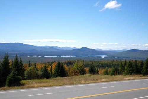
I'm going to the Jackman area to hike. Jackman is fairly remote with no other sizeable towns around it. Some people would not even consider Jackman sizeable. LOL But it is for that area. My main goal is Boundary Bald Mt.
I plan on camping at Moose River Campground from Thursday night to Saturday morning. Anyone wanting to do one or both of the hikes could join me at the campground, stay at another location, or come for one day. I have room in my tent for one person and you'd need to bring your own sleeping gear.
My hikes will be based on the weather, which is looking good. Damn, I hope I didn't jinx it! LOL
Here is some info on the mountains:
1. Boundary Bald Mt is located north of Jackman. This is top priority. Elevation is 3,640 ft. Boundary Bald is on the New England 50 Finest list.
The drive to the trailhead is on woods roads of unknown condition, but should be passable with a vehicle with good clearance underneath. The last 1.4 miles to the trailhead I do believe is only passable by 4wd.
* The drive to the trailhead is on private woods roads, and is "pass at your own risk". Logging trucks have the right away, and you MUST let them by. Land/road owners, truckers, logging companies/contractors etc. are not liable if there is an accident involving them.
Once outside of Jackman cell phone service will be spotty to non-existent.
Phones should work on mountain summits.
I'll assume the last 1.4 miles of the road will be a walk. After the road walk it is another 1.2 miles on the trail up the mountain. Total going up is 2.6 miles.
Near the end, the trail follows the ridge of the mountain with scrub growth to the summit, where there are views in all directions. The summit is not 100% wild as there are 2 radio facilities located there.
The elevation gain, including road walk, is around 1,790 ft. Plan on 4 hours for the total hike. I will consider this a moderate to strenuous hike.
I'd also like to scout for the remains of two old fire watchman's camps near where the trail leaves the road.
2. Sally Mountain is located southwest of Jackman a short distance out of town.
Elevation is 2,221 feet.
The first 1.8 miles of this hike follows the railroad tracks, unless someone has a boat or canoe. The trail from the tracks to the summit is 1.2 miles. Total going up is 3 miles.
There used to be a fire tower here but it burned years ago. There are excellent views from the open ledges at the summit.
The elevation gain is around 1,035 feet. The hike along the tracks is fairly level. Plan on 3.5 hours for this hike. I will consider this a moderate hike.
When we return to the tracks we'll continue to a campsite on the shore of Attean Pond and then head back to the trailhead. There is a beach at the pond for anyone who wants to take a dip before going back to the trailhead.
---------------------------------------------------------
I do apologize for short notice. The weather looks good and I'm praying it stays that way. I know I might be asking for a lot. LOL
Anyone wanting to join me for the entire time or to just do 1 of the hikes, sign up and we can share phone numbers. I will not have access to the Internet on my trip only phone calls and text.
My plan is to hike Boundary Bald on Friday and either hike Sally Mtn after, or hike Sally on Sat. morning.
Besides Moose River Campground there are several motels in Jackman.
Directions
**GPS may give different directions over nearby roads.
To get to Jackman from the south, take I-95 north to Fairfield, Exit 133. It is 87 miles to Jackman from I-95.
Follow U.S. Rt. 201 north through Skowhegan. Not long after entering Skowhegan you'll come to a traffic light at the intersection of U.S. Rt. 2 and Rt. 104. Turn right to continue on U.S. Rt. 201 north, going through the one-way stretch in downtown Skowhegan.
Continue north on U.S. Rt. 201 to Jackman. The stretch of road north of The Forks is notorious for moose, so keep an eye out for them...
Here are the directions to the Moose River Campground. If you are not staying at the campground we can figure out another location.
In Jackman continue north on U.S. Rt. 201. You'll cross the bridge over the Moose River and just beyond this turn right on to Heald Stream Rd. Skowhegan Savings Bank is on the corner. Follow Heald Stream Rd for 1.4 miles. The driveway to the campground will be on the right just beyond the intersection with the Moose River Rd (woods road).
Campground address:
107 Heald Stream Rd
Moose River, Maine 04945
About this event
*** Clarification ***
The 8AM meeting time is meant for when I want to leave the campground on Friday morning to drive to the trailhead for Boundary Bald.
I plan on arriving in Jackman around 5PM Thursday.
*****
I'm going to the Jackman area to hike. Jackman is fairly remote with no other sizeable towns around it. Some people would not even consider Jackman sizeable. LOL But it is for that area. My main goal is Boundary Bald Mt.
I plan on camping at Moose River Campground from Thursday night to Saturday morning. Anyone wanting to do one or both of the hikes could join me at the campground, stay at another location, or come for one day. I have room in my tent for one person and you'd need to bring your own sleeping gear.
My hikes will be based on the weather, which is looking good. Damn, I hope I didn't jinx it! LOL
Here is some info on the mountains:
1. Boundary Bald Mt is located north of Jackman. This is top priority. Elevation is 3,640 ft. Boundary Bald is on the New England 50 Finest list.
The drive to the trailhead is on woods roads of unknown condition, but should be passable with a vehicle with good clearance underneath. The last 1.4 miles to the trailhead I do believe is only passable by 4wd.
* The drive to the trailhead is on private woods roads, and is "pass at your own risk". Logging trucks have the right away, and you MUST let them by. Land/road owners, truckers, logging companies/contractors etc. are not liable if there is an accident involving them.
Once outside of Jackman cell phone service will be spotty to non-existent.
Phones should work on mountain summits.
I'll assume the last 1.4 miles of the road will be a walk. After the road walk it is another 1.2 miles on the trail up the mountain. Total going up is 2.6 miles.
Near the end, the trail follows the ridge of the mountain with scrub growth to the summit, where there are views in all directions. The summit is not 100% wild as there are 2 radio facilities located there.
The elevation gain, including road walk, is around 1,790 ft. Plan on 4 hours for the total hike. I will consider this a moderate to strenuous hike.
I'd also like to scout for the remains of two old fire watchman's camps near where the trail leaves the road.
2. Sally Mountain is located southwest of Jackman a short distance out of town.
Elevation is 2,221 feet.
The first 1.8 miles of this hike follows the railroad tracks, unless someone has a boat or canoe. The trail from the tracks to the summit is 1.2 miles. Total going up is 3 miles.
There used to be a fire tower here but it burned years ago. There are excellent views from the open ledges at the summit.
The elevation gain is around 1,035 feet. The hike along the tracks is fairly level. Plan on 3.5 hours for this hike. I will consider this a moderate hike.
When we return to the tracks we'll continue to a campsite on the shore of Attean Pond and then head back to the trailhead. There is a beach at the pond for anyone who wants to take a dip before going back to the trailhead.
---------------------------------------------------------
I do apologize for short notice. The weather looks good and I'm praying it stays that way. I know I might be asking for a lot. LOL
Anyone wanting to join me for the entire time or to just do 1 of the hikes, sign up and we can share phone numbers. I will not have access to the Internet on my trip only phone calls and text.
My plan is to hike Boundary Bald on Friday and either hike Sally Mtn after, or hike Sally on Sat. morning.
Besides Moose River Campground there are several motels in Jackman.
Directions to the trailhead
Get directions**GPS may give different directions over nearby roads.
To get to Jackman from the south, take I-95 north to Fairfield, Exit 133. It is 87 miles to Jackman from I-95.
Follow U.S. Rt. 201 north through Skowhegan. Not long after entering Skowhegan you'll come to a traffic light at the intersection of U.S. Rt. 2 and Rt. 104. Turn right to continue on U.S. Rt. 201 north, going through the one-way stretch in downtown Skowhegan.
Continue north on U.S. Rt. 201 to Jackman. The stretch of road north of The Forks is notorious for moose, so keep an eye out for them...
Here are the directions to the Moose River Campground. If you are not staying at the campground we can figure out another location.
In Jackman continue north on U.S. Rt. 201. You'll cross the bridge over the Moose River and just beyond this turn right on to Heald Stream Rd. Skowhegan Savings Bank is on the corner. Follow Heald Stream Rd for 1.4 miles. The driveway to the campground will be on the right just beyond the intersection with the Moose River Rd (woods road).
Campground address:
107 Heald Stream Rd
Moose River, Maine 04945
Who's going (1)
 GUEST MEMBER
 Questions about this event?
Reach out to the host, BillyB1976, for route details, carpooling, or what to bring.
Email the hostYou can also ask in the event discussion below.
Event discussion
No comments yet.
Log in to join the conversation.