
June 29th, Sat. Hike, Big Branch Falls Shenandoah NP
June 29th, Sat. Hike, Big Branch Falls Shenandoah NP
June 29th, Sat. Hike, Big Branch Falls Shenandoah NP
June 29th, Sat. Hike, Big Branch Falls Shenandoah NP
Details
This hike starts off at Blackrock Gap going down Moorman’s River Fire road. At mile 0.1, cross a small branch of the river which then parallels the path moving into an area with lots of mountain laurel. At mile 1.1, we’ll come to a gate on the road.
At mile 1.4 we’ll hike a junction in the trail. Turn RIGHT at this junction and cross the North Fork Moorman’s river on rocks. The trail follows the river downstream.
At Mile 1.6, turn RIGHT at another junction and pass a ramshackle hunter’s camp on your left.
At mile 1.8, cross the river via the rocks. We’ll stay on the west side of the river the rest of the hike down.
At mile 2.5, we’ll cross Shop Run and start a fairly steep descent into and old washed out area which is pretty rocky indications of a huge mudslide in 1995 in this area.
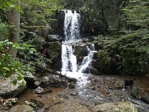
At mile 3.3, we’ll come to Big Branch Falls. There is side trail, at your RIGHT, that brings you to the base of the falls into a pool. Total Hike is 6.8 miles
Bring waterproof hiking boots, water, lunch, sweat rag, and snacks. Since this is the Appalachian Mountains, bring a jacket and poncho (or waterproof jacket) for the occasional summer shower.
Directions
From Rockfish Gap park entrance, take Skyline Drive, Shenandoah National Park, north for 17.2 miles to Blackrock Gap parking lot, MM 87.4, on your left.
About this event
This hike starts off at Blackrock Gap going down Moorman’s River Fire road. At mile 0.1, cross a small branch of the river which then parallels the path moving into an area with lots of mountain laurel. At mile 1.1, we’ll come to a gate on the road.
At mile 1.4 we’ll hike a junction in the trail. Turn RIGHT at this junction and cross the North Fork Moorman’s river on rocks. The trail follows the river downstream.
At Mile 1.6, turn RIGHT at another junction and pass a ramshackle hunter’s camp on your left.
At mile 1.8, cross the river via the rocks. We’ll stay on the west side of the river the rest of the hike down.
At mile 2.5, we’ll cross Shop Run and start a fairly steep descent into and old washed out area which is pretty rocky indications of a huge mudslide in 1995 in this area.
At mile 3.3, we’ll come to Big Branch Falls. There is side trail, at your RIGHT, that brings you to the base of the falls into a pool. Total Hike is 6.8 miles
Bring waterproof hiking boots, water, lunch, sweat rag, and snacks. Since this is the Appalachian Mountains, bring a jacket and poncho (or waterproof jacket) for the occasional summer shower.
Directions to the trailhead
Get directionsFrom Rockfish Gap park entrance, take Skyline Drive, Shenandoah National Park, north for 17.2 miles to Blackrock Gap parking lot, MM 87.4, on your left.
Who's going (1)
 GUEST MEMBER
 Questions about this event?
Questions for the host, TrailGuyEric, about route details, carpooling, or what to bring? Ask in the event discussion below.
Event discussion
No comments yet.
Log in to join the conversation.