
Mt. Jefferson via Castle Ravine
Join us for a hike that includes it all. We will be hiking up to Mt Jefferson (5,712 feet) on the less traveled Castle Ravine trail!
Mt. Jefferson via Castle Ravine
Join us for a hike that includes it all. We will be hiking up to Mt Jefferson (5,712 feet) on the less traveled Castle Ravine trail!
Details
Join us for a hike that includes it all. We will be hiking up to Mt Jefferson (5,712 feet) on the less traveled Castle Ravine trail! Time permitting when we return back to the Mad River Lodge, we can cool off in the Mad River followed by a BBQ.
The round trip will be 10.2 miles and a total elevation gain of 4,240 feet. For strong and experienced hikers, the little-used ascent through Castle Ravine is one of the wildest and most beautiful trips in the Presidentials! We will be hiking next to gushing rivers and also cross them at 16 times. Depending on water levels, this can prove challenging and refreshing!.
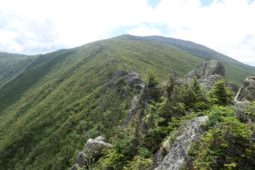
The section up the headwall is a difficult scramble where we will be faced with steep sections (isn't for the faint of heart). The route is on the Terrifying 25 list so we will be hitting 2 for one on this hike. At the top we will be rewarded with panoramic views across the northern section of the presidential range and beyond. Using the Castle Trail for our return, this is a spectacular loop!
Round trip distance: 10.2 miles
Vertical feet: 4250
Approximate time: 8-9 hours
Difficulty: Very Strenuous
We will ascend from the trailhead at Bowman following the Castle and Israel Ridge trails reaching the Castle Ravine trail at 1.7 miles. We then start crossing the Israel River and Castle Brook multiple times. At 3.2 miles we reach the Link as we continue gradually up the valley through wild, lush, fir forest, After the Link leaves right we'll start to clamber around boulders where we begin a steep ascent up the headwall on a narrow, rough, winding path. At 4.5 miles we'll reach Randalph Path and the ridge reaching the summit at 5.2 miles. We’ll then descend down the Castle Trail's Castellated Ridge, with some tough scrambling down the Castles.
What to wear/bring: Wear clothing suitable for the hike in layers...no cotton or blue jeans. Have a rain jacket in the event of inclement weather. Bring along plenty of water (at least 2 liters), lunch, snacks and anything else you may require for a day hike. Contact us if you have any questions.
Afterwards: Everyone is welcome to join us back at our house in Waterville Valley to relax on our deck [BYOB and bring snacks] and a BBQ! We ask $10 per person to help pay for our food costs. Please let us know you will join us for the BBQ so we have enough food. Showers are available so bring a change of clothing to make your visit with us more comfortable.
Lodging Option: Bunk beds are available at our house [with Wi Fi] near Waterville Valley, NH for Friday and/or Saturday nights. It's $25 for Friday night, $35 for Saturday that includes dinner or $60 for the weekend. Coffee/bagels each morning and linen/blankets/towels are provided. Space is limited so email ASAP to reserve a bunk!
Directions
The trailhead is at Bowman on US 2, 3.0 miles west of the Appalachia parking area and 4.2 miles east of the junction of US 2 and NH 115. We'll be driving a blue Toyota truck.
About this event
Join us for a hike that includes it all. We will be hiking up to Mt Jefferson (5,712 feet) on the less traveled Castle Ravine trail! Time permitting when we return back to the Mad River Lodge, we can cool off in the Mad River followed by a BBQ.
The round trip will be 10.2 miles and a total elevation gain of 4,240 feet. For strong and experienced hikers, the little-used ascent through Castle Ravine is one of the wildest and most beautiful trips in the Presidentials! We will be hiking next to gushing rivers and also cross them at 16 times. Depending on water levels, this can prove challenging and refreshing!.
The section up the headwall is a difficult scramble where we will be faced with steep sections (isn't for the faint of heart). The route is on the Terrifying 25 list so we will be hitting 2 for one on this hike. At the top we will be rewarded with panoramic views across the northern section of the presidential range and beyond. Using the Castle Trail for our return, this is a spectacular loop!
Round trip distance: 10.2 miles
Vertical feet: 4250
Approximate time: 8-9 hours
Difficulty: Very Strenuous
We will ascend from the trailhead at Bowman following the Castle and Israel Ridge trails reaching the Castle Ravine trail at 1.7 miles. We then start crossing the Israel River and Castle Brook multiple times. At 3.2 miles we reach the Link as we continue gradually up the valley through wild, lush, fir forest, After the Link leaves right we'll start to clamber around boulders where we begin a steep ascent up the headwall on a narrow, rough, winding path. At 4.5 miles we'll reach Randalph Path and the ridge reaching the summit at 5.2 miles. We’ll then descend down the Castle Trail's Castellated Ridge, with some tough scrambling down the Castles.
What to wear/bring: Wear clothing suitable for the hike in layers...no cotton or blue jeans. Have a rain jacket in the event of inclement weather. Bring along plenty of water (at least 2 liters), lunch, snacks and anything else you may require for a day hike. Contact us if you have any questions.
Afterwards: Everyone is welcome to join us back at our house in Waterville Valley to relax on our deck [BYOB and bring snacks] and a BBQ! We ask $10 per person to help pay for our food costs. Please let us know you will join us for the BBQ so we have enough food. Showers are available so bring a change of clothing to make your visit with us more comfortable.
Lodging Option: Bunk beds are available at our house [with Wi Fi] near Waterville Valley, NH for Friday and/or Saturday nights. It's $25 for Friday night, $35 for Saturday that includes dinner or $60 for the weekend. Coffee/bagels each morning and linen/blankets/towels are provided. Space is limited so email ASAP to reserve a bunk!
Directions to the trailhead
Get directionsThe trailhead is at Bowman on US 2, 3.0 miles west of the Appalachia parking area and 4.2 miles east of the junction of US 2 and NH 115. We'll be driving a blue Toyota truck.
Who's going (5)


Questions about this event?
Reach out to the host, Gandalf, for route details, carpooling, or what to bring.
Email the hostYou can also ask in the event discussion below.
Event discussion
No comments yet.
Log in to join the conversation.