
Quaggy Jo Mtn - Aroostook State Park
Snowshoe hike up Quaggy Jo Mtn, Presque Isle, Maine
Quaggy Jo Mtn - Aroostook State Park
Snowshoe hike up Quaggy Jo Mtn, Presque Isle, Maine
Details
** Currently -8 here at the house. Heading out shortly. ** Beard freezing weather.. LOL
Snowshoe hike up Quaggy Jo Mtn. Route will be up the south peak, go along the ridgeline, and down the north peak.
The south peak is rather steep. You go up about 660 ft. in elevation, and a good portion of that is in a 3/4 miles stretch. It is basically straight up - ! Yikes!!!.. I said straight...! LOL Not much for switchbacks. On the final steep stretch, I normally find myself going off trail and holding onto trees, as it is almost too steep for snowshoes.
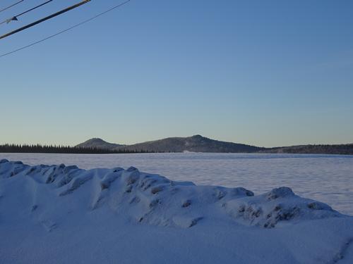
There is an excellent view over Echo Lake and the surrounding countryside at the top of the final steep stretch. After this, the going will be easier.
At the south peak, there is a viewpoint, where you can see all the way to Katahdin - 65 miles to the southwest - on a clear day.
The hike continues along the ridgeline, with a viewpoint with a picnic table and lean-to about 3/4 of the way across. Ridgeline hike is fairly easy.
There are also two good viewpoints at the north peak.
From the north peak, we go back down to the parking lot. This trail is not as steep as the south peak, and the going is normally quick.
The hike is almost 3 miles. Total elevation gain is around 900 ft, with about 660 feet going from the parking lot to the south peak. Plan on 3 hours, depending on conditions. Should be faster if we don't have to break trail, but could be slower if we have to break trail the entire distance.
The elevation of the south peak is 1,213 ft. North peak is 1,141 ft.
I'm labeling the hike moderate to strenuous because if we need to break trail up the south peak, that will be strenuous, as it is steep. Sometimes, one step forward, two steps back. LOL I need to buy trekking poles. LOL
I've used stabilizers on the trail, but never used microspikes, but should bring something for traction to be safe.
No way to predict weather, but be prepared for COLD. LOL Bad weather could also cancel this as well.
I'm hosting this hike on the same day Aroostook State Park is holding Winter Family Fun Day. The cost to enter the park is $1.50 per person, and INCLUDES a hot lunch... :)
For anyone who does not want to take part in this hike, but wants to check out the park, there is plenty to do. There is FREE equipment available for the day. First come-first serve. Snowshoe trails and groomed XC ski trails. The official events start at 10 AM, but I want to start the hike by 8:30 AM.
I've gone to several Winter Family Fun Day's over the years, and even with a lot of people in the park, I normally have the mountain to myself, as most people stay on the easier trails in the park.
I know this is a long drive for most people on GO. I do have 1 double bed, for anyone who'd like to spend the night, before and/or after. I can host 1 couple, 1 single guy, or 2 guys who don't care if they share bed. LOL I might even be able to convince my partner to give up his queen bed. LOL :) There are also several motels in Presque Isle.
Directions
Directions from the south:
Get on I-95, and stay on it almost to the end in Houlton. Second to last exit. Exit 302. Yes, that is 302 miles from Kittery!! Give or take a few miles. LOL
Go left at the lights at the bottom of the off ramp, and stay in the right hand lane. U.S. Rt. 1 north.
Go north 26 miles to Mars Hill. In "downtown" Mars Hill, turn left at the caution light - staying on U.S. Rt. 1 north.
Go 10.5 miles, and turn left on to Spragueville Rd. There are signs for Aroostook State Park. Go 1 mile, and turn left on to State Park Rd, and follow it 0.8 miles to the park gate at the end. Continue through the gate to the parking lot at the end of the road.
I want to start the hike by 8:30 A.M. I'll be in the large parking lot at the end of the road. Black Nisan Frontier pickup truck, plate # 6039 IJ.
Address is, 87 State Park Rd, Presque Isle, ME.... BUT, when I enter that into Google, it puts 87 State Park Rd up on Quaggy Jo Mtn... What the hell. There is not even a road there. LOL
About this event
** Currently -8 here at the house. Heading out shortly. ** Beard freezing weather.. LOL
Snowshoe hike up Quaggy Jo Mtn. Route will be up the south peak, go along the ridgeline, and down the north peak.
The south peak is rather steep. You go up about 660 ft. in elevation, and a good portion of that is in a 3/4 miles stretch. It is basically straight up - ! Yikes!!!.. I said straight...! LOL Not much for switchbacks. On the final steep stretch, I normally find myself going off trail and holding onto trees, as it is almost too steep for snowshoes.
There is an excellent view over Echo Lake and the surrounding countryside at the top of the final steep stretch. After this, the going will be easier.
At the south peak, there is a viewpoint, where you can see all the way to Katahdin - 65 miles to the southwest - on a clear day.
The hike continues along the ridgeline, with a viewpoint with a picnic table and lean-to about 3/4 of the way across. Ridgeline hike is fairly easy.
There are also two good viewpoints at the north peak.
From the north peak, we go back down to the parking lot. This trail is not as steep as the south peak, and the going is normally quick.
The hike is almost 3 miles. Total elevation gain is around 900 ft, with about 660 feet going from the parking lot to the south peak. Plan on 3 hours, depending on conditions. Should be faster if we don't have to break trail, but could be slower if we have to break trail the entire distance.
The elevation of the south peak is 1,213 ft. North peak is 1,141 ft.
I'm labeling the hike moderate to strenuous because if we need to break trail up the south peak, that will be strenuous, as it is steep. Sometimes, one step forward, two steps back. LOL I need to buy trekking poles. LOL
I've used stabilizers on the trail, but never used microspikes, but should bring something for traction to be safe.
No way to predict weather, but be prepared for COLD. LOL Bad weather could also cancel this as well.
I'm hosting this hike on the same day Aroostook State Park is holding Winter Family Fun Day. The cost to enter the park is $1.50 per person, and INCLUDES a hot lunch... :)
For anyone who does not want to take part in this hike, but wants to check out the park, there is plenty to do. There is FREE equipment available for the day. First come-first serve. Snowshoe trails and groomed XC ski trails. The official events start at 10 AM, but I want to start the hike by 8:30 AM.
I've gone to several Winter Family Fun Day's over the years, and even with a lot of people in the park, I normally have the mountain to myself, as most people stay on the easier trails in the park.
I know this is a long drive for most people on GO. I do have 1 double bed, for anyone who'd like to spend the night, before and/or after. I can host 1 couple, 1 single guy, or 2 guys who don't care if they share bed. LOL I might even be able to convince my partner to give up his queen bed. LOL :) There are also several motels in Presque Isle.
Directions to the trailhead
Get directionsDirections from the south:
Get on I-95, and stay on it almost to the end in Houlton. Second to last exit. Exit 302. Yes, that is 302 miles from Kittery!! Give or take a few miles. LOL
Go left at the lights at the bottom of the off ramp, and stay in the right hand lane. U.S. Rt. 1 north.
Go north 26 miles to Mars Hill. In "downtown" Mars Hill, turn left at the caution light - staying on U.S. Rt. 1 north.
Go 10.5 miles, and turn left on to Spragueville Rd. There are signs for Aroostook State Park. Go 1 mile, and turn left on to State Park Rd, and follow it 0.8 miles to the park gate at the end. Continue through the gate to the parking lot at the end of the road.
I want to start the hike by 8:30 A.M. I'll be in the large parking lot at the end of the road. Black Nisan Frontier pickup truck, plate # 6039 IJ.
Address is, 87 State Park Rd, Presque Isle, ME.... BUT, when I enter that into Google, it puts 87 State Park Rd up on Quaggy Jo Mtn... What the hell. There is not even a road there. LOL
Who's going (2)
 GUEST MEMBER
 Questions about this event?
Reach out to the host, BillyB1976, for route details, carpooling, or what to bring.
Email the hostYou can also ask in the event discussion below.
Event discussion
Log in to join the conversation.