
Mount Megunticook, Maiden Cliff, and Mount Battie Loop Trail
Mount Megunticook, Maiden Cliff, and Mount Battie Loop
Mount Megunticook, Maiden Cliff, and Mount Battie Loop Trail
Mount Megunticook, Maiden Cliff, and Mount Battie Loop
Details
Mount Megunticook, Maiden Cliff, and Mount Battie Loop is a 8.6 mile loop trail located near Camden, Maine rated as moderate/difficult. Elevation gain 2352 ft. Dogs are also able to use this trail. Average hiking time 4 hrs.
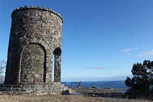
Starting at the Camden Hills State Park entrance on Route 1, there is beautiful hike up to Ocean Lookout. The 2nd half of this hike displays lots of civil conservation corps, 1930's, handsome stonework. From Ocean Lookout, the trail goes to Mt. Megunticook summit (1385 ft).Then, proceeds on the Ridge trail over the Millerite Ledges, 2.1 to Maidens Cliff (elev. 850 ft.). That has outstanding views out over the lake, and back to Penobscot Bay. Afterwards, back to the Route 1 entrance by way of the Jack Williams trail (which is below the Ridge). This hooks into the beautifulTablelands trail and heads over to Mount Battie (elev. 800 ft.) with its handsome view over Camden and the harbor.
Meeting place at the Camden Hill State Park, small parking lot off Battie Rd. Dress with warm layers of non-cotton couture, good hiking boots and bring a yummy lunch. At the end of a hike we can meet in downtown Camden for food and/or hot/cold beverages.
This is my first time putting a hike together and I'm still learning, so please be kind, patient and let me know if I missed any information or details you need to know and I will do my best!
Directions
Rt 1 north to Camden, go through the town and continue on Rt 1/S.High St, it will become Rt 1/Belfast Rd. You will travel about 1.8 milesThe sign for Camden Hills State Park will be on the left. You want to stick to the left Mt Battie Rd. I will be wearing a red-orangy jacket and grayish pants, my car a red Toyota Corolla. Will aim to get there earlier
About this event
Mount Megunticook, Maiden Cliff, and Mount Battie Loop is a 8.6 mile loop trail located near Camden, Maine rated as moderate/difficult. Elevation gain 2352 ft. Dogs are also able to use this trail. Average hiking time 4 hrs.
Starting at the Camden Hills State Park entrance on Route 1, there is beautiful hike up to Ocean Lookout. The 2nd half of this hike displays lots of civil conservation corps, 1930's, handsome stonework. From Ocean Lookout, the trail goes to Mt. Megunticook summit (1385 ft).Then, proceeds on the Ridge trail over the Millerite Ledges, 2.1 to Maidens Cliff (elev. 850 ft.). That has outstanding views out over the lake, and back to Penobscot Bay. Afterwards, back to the Route 1 entrance by way of the Jack Williams trail (which is below the Ridge). This hooks into the beautifulTablelands trail and heads over to Mount Battie (elev. 800 ft.) with its handsome view over Camden and the harbor.
Meeting place at the Camden Hill State Park, small parking lot off Battie Rd. Dress with warm layers of non-cotton couture, good hiking boots and bring a yummy lunch. At the end of a hike we can meet in downtown Camden for food and/or hot/cold beverages.
This is my first time putting a hike together and I'm still learning, so please be kind, patient and let me know if I missed any information or details you need to know and I will do my best!
Directions to the trailhead
Get directionsRt 1 north to Camden, go through the town and continue on Rt 1/S.High St, it will become Rt 1/Belfast Rd. You will travel about 1.8 milesThe sign for Camden Hills State Park will be on the left. You want to stick to the left Mt Battie Rd. I will be wearing a red-orangy jacket and grayish pants, my car a red Toyota Corolla. Will aim to get there earlier
Who's going (2)


Questions about this event?
Reach out to the host, baezfred, for route details, carpooling, or what to bring.
Email the hostYou can also ask in the event discussion below.
Event discussion
Log in to join the conversation.