
Kitching Creek Loop Trail
A slice of the old South Florida before it became urbanized
Kitching Creek Loop Trail
A slice of the old South Florida before it became urbanized
Details
We will be hiking the Kitching Creek Loop Trail at Jonathan Dickinson State Park. We are starting this hike at 9:00 a.m., but I suggest getting to the trailhead before then. Jonathan Dickinson is a very popular park, and it fills up very quickly on weekends, to the point that there may not be any parking at the trailhead after 10:00. Also note that there is a $6 per carload entrance fee to the Park.
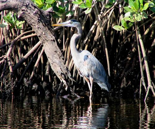
The Kitching Creek Loop Trail is 7.4 miles long, and it starts at the parking area near the Pavilion & picnic area. The main photo was taken at the edge of the parking lot, by the trailhead. The trail is fairly flat all the way, and goes through typical South Florida scrubland, as it borders the Loxahatchee river, and Kitching Creek. At this time of the year there will be plenty of birds, especially along the water, and if we are lucky, we'll get to see some deer or other furry creatures along the scrub palmettos. Bring plenty of water, hat, sunscreen, bug spray, and comfortable shoes. Also bring snacks, and lunch. We should be done by early afternoon, with plenty of time to take a very restoring break at Guanabana's, by the Loxahatchee river in Jupiter (Happy Hour starts at 3:00 p.m., and they have great appetizers).
Directions
We will meet at the trailhead parking lot for the Kitching Creek Loop Trail. If Hurricane Irma didn't knock it down, there is a trail map by the start of the trail, which is a good place to meet at. Just in case, when you enter the Park and pay your fee, ask for a map of the Park and trail system. If you are not sure, ask for directions to the "Pavilion" picnic area, which is by the trailhead. Let me know if you'd like to carpool to the Park.
Directions from the South: On I-95, get off at exit 87A. Go east on Indiantown Road to US 1. Take left (north) at US1, go about five miles, and the Park entrance will be on your left, right after you enter Martin County. For the Turnpike, follow the same directions as above, except that you get off at Exit 116 (Jupiter/Indiantown Road).
Directions from the North: On I-95, get off at exit 96, and go east on Bridge Road to US 1. Turn right (south) on US1, and go 3 miles to the Park entrance on your right.
If you want to program your GPS. The address of the Park entrance is 16450 S.E. Federal Hwy, Hobe Sound, FL, 33455
About this event
We will be hiking the Kitching Creek Loop Trail at Jonathan Dickinson State Park. We are starting this hike at 9:00 a.m., but I suggest getting to the trailhead before then. Jonathan Dickinson is a very popular park, and it fills up very quickly on weekends, to the point that there may not be any parking at the trailhead after 10:00. Also note that there is a $6 per carload entrance fee to the Park.
The Kitching Creek Loop Trail is 7.4 miles long, and it starts at the parking area near the Pavilion & picnic area. The main photo was taken at the edge of the parking lot, by the trailhead. The trail is fairly flat all the way, and goes through typical South Florida scrubland, as it borders the Loxahatchee river, and Kitching Creek. At this time of the year there will be plenty of birds, especially along the water, and if we are lucky, we'll get to see some deer or other furry creatures along the scrub palmettos. Bring plenty of water, hat, sunscreen, bug spray, and comfortable shoes. Also bring snacks, and lunch. We should be done by early afternoon, with plenty of time to take a very restoring break at Guanabana's, by the Loxahatchee river in Jupiter (Happy Hour starts at 3:00 p.m., and they have great appetizers).
Directions to the trailhead
Get directionsWe will meet at the trailhead parking lot for the Kitching Creek Loop Trail. If Hurricane Irma didn't knock it down, there is a trail map by the start of the trail, which is a good place to meet at. Just in case, when you enter the Park and pay your fee, ask for a map of the Park and trail system. If you are not sure, ask for directions to the "Pavilion" picnic area, which is by the trailhead. Let me know if you'd like to carpool to the Park.
Directions from the South: On I-95, get off at exit 87A. Go east on Indiantown Road to US 1. Take left (north) at US1, go about five miles, and the Park entrance will be on your left, right after you enter Martin County. For the Turnpike, follow the same directions as above, except that you get off at Exit 116 (Jupiter/Indiantown Road).
Directions from the North: On I-95, get off at exit 96, and go east on Bridge Road to US 1. Turn right (south) on US1, and go 3 miles to the Park entrance on your right.
If you want to program your GPS. The address of the Park entrance is 16450 S.E. Federal Hwy, Hobe Sound, FL, 33455
Who's going (1)
 SUSTAINING
 Questions about this event?
Reach out to the host, JPHiker, for route details, carpooling, or what to bring.
Email the hostYou can also ask in the event discussion below.
Event discussion
No comments yet.
Log in to join the conversation.