
Mt Hancock Slide Loop Hike
A Hancock Loop Hike utilizing the steep, but spectacular Arrow Slide.
Mt Hancock Slide Loop Hike
A Hancock Loop Hike utilizing the steep, but spectacular Arrow Slide.
Details
Join me for a loop hike around Hancock (4420') and South Hancock (4319') Mountains. This hike will have a twist over the classic loop in that we'll be climbing the Arrow Slide to ascend Mt. Hancock. Located at the southern border of the Pemigewasset Wilderness, Mount Hancock is characterized by a long ridge with several peaks, most importantly the North Peak (4420') and the South Peak (4319'). Although both peaks are wooded to the top, nice views are available near each summit of Mt. Osceola and the Sandwich Range to the south, as well as into the Pemigewasset Wilderness...towards Owl's Head and Franconia Ridge to the west. The trail is mostly modest in grade until the junction with the north and south legs of the loop trail...afterwhich it becomes steep for 0.5 mile to the first summit and ridgeline.
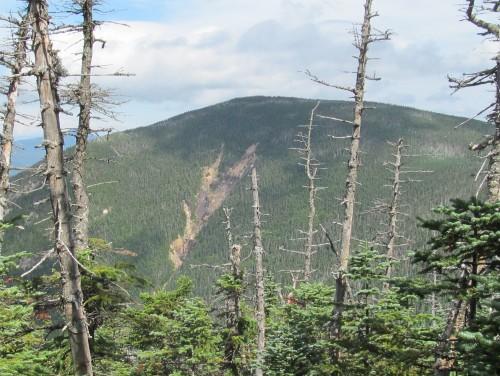
IMPORTANT NOTE: The Arrow Slide is very steep over some smooth granite and scree, but it offers spectactular views of South Hancock and the Osceolas all the way up. A very small stretch of difficult bushwhaching is required...about 20-40 feet (mostly from the top of the slide into the woods).
Total Distance and Elevation Gain: 9.7 miles with approximately 3000 feet in cumulative elevation gain.
Total Time: About 7-8 hours depending on breaks and group's speed.
Rain or harsh weather may postpone to another date or cancel, as appropriate.
What to Bring: Typical summer hiking gear should be appropriate: convertible hiking pants/shorts, good sturdy hiking boots with good traction and thick socks, a windbreaker/raingear. Also bring along lunch, snacks and plenty of water (at least 2-L). Optionally, pack sunscreen and anything else that you may require for a day hike.
Carpooling: Contact other participants or the trip leader to arrange for a rideshare to the trailhead.
Afterwards: If there is sufficient interest, we will have drinks and/or dinner in Lincoln or North Woodstock.
Directions
Take Exit 32 off of Route 93 for Lincoln. Continue east on Route 112 (Kancamagus Highway) for 10.7 miles. Parking for this trip is at the Hancock Roadside Overlook. This is just beyond the hairpin curve in the road. The parking lot will be on the southwest side of the road. Look for a gray Hyundai Elantra.
For GPS Users: Hancock Overlook on the Kancamagus Highway (44.040728,-71.523467).
About this event
Join me for a loop hike around Hancock (4420') and South Hancock (4319') Mountains. This hike will have a twist over the classic loop in that we'll be climbing the Arrow Slide to ascend Mt. Hancock. Located at the southern border of the Pemigewasset Wilderness, Mount Hancock is characterized by a long ridge with several peaks, most importantly the North Peak (4420') and the South Peak (4319'). Although both peaks are wooded to the top, nice views are available near each summit of Mt. Osceola and the Sandwich Range to the south, as well as into the Pemigewasset Wilderness...towards Owl's Head and Franconia Ridge to the west. The trail is mostly modest in grade until the junction with the north and south legs of the loop trail...afterwhich it becomes steep for 0.5 mile to the first summit and ridgeline.
IMPORTANT NOTE: The Arrow Slide is very steep over some smooth granite and scree, but it offers spectactular views of South Hancock and the Osceolas all the way up. A very small stretch of difficult bushwhaching is required...about 20-40 feet (mostly from the top of the slide into the woods).
Total Distance and Elevation Gain: 9.7 miles with approximately 3000 feet in cumulative elevation gain.
Total Time: About 7-8 hours depending on breaks and group's speed.
Rain or harsh weather may postpone to another date or cancel, as appropriate.
What to Bring: Typical summer hiking gear should be appropriate: convertible hiking pants/shorts, good sturdy hiking boots with good traction and thick socks, a windbreaker/raingear. Also bring along lunch, snacks and plenty of water (at least 2-L). Optionally, pack sunscreen and anything else that you may require for a day hike.
Carpooling: Contact other participants or the trip leader to arrange for a rideshare to the trailhead.
Afterwards: If there is sufficient interest, we will have drinks and/or dinner in Lincoln or North Woodstock.
Directions to the trailhead
Get directionsTake Exit 32 off of Route 93 for Lincoln. Continue east on Route 112 (Kancamagus Highway) for 10.7 miles. Parking for this trip is at the Hancock Roadside Overlook. This is just beyond the hairpin curve in the road. The parking lot will be on the southwest side of the road. Look for a gray Hyundai Elantra.
For GPS Users: Hancock Overlook on the Kancamagus Highway (44.040728,-71.523467).
Who's going (1)
 GUEST MEMBER
 Questions about this event?
Reach out to the host, shep5, for route details, carpooling, or what to bring.
Email the hostYou can also ask in the event discussion below.
Event discussion
No comments yet.
Log in to join the conversation.