
Carter Mountains Hike
A Hike of the Carters including Carter Dome, Hight and Middle and South Carter.
Carter Mountains Hike
A Hike of the Carters including Carter Dome, Hight and Middle and South Carter.
Details
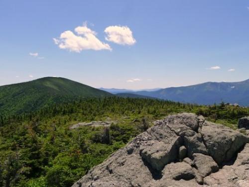
Join me for a hike over the Carter Mountains, which make up part of the Carter Moriah Range. These peaks lie between Pinkham Notch and the Wild River Valley. We will traverse this set of peaks by ascending Carter Dome (4832') from Carter Notch and then continuing over Mt. Hight (4675'), South Carter (4430') and Middle Carter 4610'). We'll descend via the Imp Face (3165'). While most of the summits are primarily wooded, Mt. Hight offers spectacular views in all directions. Additionally, there are limited views off of Carter Dome, at points along the ridge and off of the Imp Face ledge.
Total Distance and Elevation Gain: 13.6 miles with approximately 4500 feet in cumulative elevation gain.
Total Time: 9 hours depending on breaks and group's speed.
Rain or harsh weather may postpone to another date or cancel, as appropriate.
What to Bring: Typical summer hiking gear should be appropriate: convertible hiking pants/shorts, good sturdy hiking boots with thick socks, a windbreaker/raingear. Also bring along lunch, snacks and plenty of water (at least 2-L). Note: Additional water is available at the hut and at a spring in Zeta Pass. Optionally, pack sunscreen and anything else that you may require for a day hike.
Carpooling: Contact other participants to arrange for a rideshare to the trailhead.
Afterwards: If there is sufficient interest, we will have drinks and/or dinner in the area.
Directions
FROM THE NORTH: The trailhead is approximately 5.4 miles south of Gorham, NH along Route 16.
FROM THE SOUTH: The trailhead is approximately 17.1 miles north of Glen, NH along Route 16. The trailhead is well signed and is on the east side of the road.
NOTE: There are 2 trailheads for the Imp Trail. Make certain to watch for the northern leg of the trail. These trailheads are approximately 0.2-0.3 miles apart and are both along the east side of the road.
Look for a grey Hyundai Elantra. This hike requires car spotting...Once we've all met up, we'll drive to the other trailhead for the Nineteen Mile Brook Trail.
For GPS Users: Route 16 (White Mountain Road); Gorham, NH 03581 (44.323412, -71.216897).
About this event
Join me for a hike over the Carter Mountains, which make up part of the Carter Moriah Range. These peaks lie between Pinkham Notch and the Wild River Valley. We will traverse this set of peaks by ascending Carter Dome (4832') from Carter Notch and then continuing over Mt. Hight (4675'), South Carter (4430') and Middle Carter 4610'). We'll descend via the Imp Face (3165'). While most of the summits are primarily wooded, Mt. Hight offers spectacular views in all directions. Additionally, there are limited views off of Carter Dome, at points along the ridge and off of the Imp Face ledge.
Total Distance and Elevation Gain: 13.6 miles with approximately 4500 feet in cumulative elevation gain.
Total Time: 9 hours depending on breaks and group's speed.
Rain or harsh weather may postpone to another date or cancel, as appropriate.
What to Bring: Typical summer hiking gear should be appropriate: convertible hiking pants/shorts, good sturdy hiking boots with thick socks, a windbreaker/raingear. Also bring along lunch, snacks and plenty of water (at least 2-L). Note: Additional water is available at the hut and at a spring in Zeta Pass. Optionally, pack sunscreen and anything else that you may require for a day hike.
Carpooling: Contact other participants to arrange for a rideshare to the trailhead.
Afterwards: If there is sufficient interest, we will have drinks and/or dinner in the area.
Directions to the trailhead
Get directionsFROM THE NORTH: The trailhead is approximately 5.4 miles south of Gorham, NH along Route 16.
FROM THE SOUTH: The trailhead is approximately 17.1 miles north of Glen, NH along Route 16. The trailhead is well signed and is on the east side of the road.
NOTE: There are 2 trailheads for the Imp Trail. Make certain to watch for the northern leg of the trail. These trailheads are approximately 0.2-0.3 miles apart and are both along the east side of the road.
Look for a grey Hyundai Elantra. This hike requires car spotting...Once we've all met up, we'll drive to the other trailhead for the Nineteen Mile Brook Trail.
For GPS Users: Route 16 (White Mountain Road); Gorham, NH 03581 (44.323412, -71.216897).
Who's going (2)
 GUEST MEMBER
 Questions about this event?
Reach out to the host, shep5, for route details, carpooling, or what to bring.
Email the hostYou can also ask in the event discussion below.
Event discussion
No comments yet.
Log in to join the conversation.