
Franconia Ridge Loop Trail in Midweek
Midweek Hike of the Always Popular Franconia Ridge Trail
Franconia Ridge Loop Trail in Midweek
Midweek Hike of the Always Popular Franconia Ridge Trail
Details
The Franconia Ridge Trail is one of the "classic" White Mountain hikes because of the outstanding views from its exposed alpine ridge. It is a fairly strenuous hike, as it covers a total of 8.8 miles, and goes over one four thousand footer (Mt. Little Haystack) and two of the highest peaks in the White Mountains: Mt. Lafayette (5,260') and Mt. Lincoln (5,089'). Little Haystack at 4,780' does not count for the Four Thousand Peakbagging Club, because it is dwarfed by both Lafayette and Lincoln, and yet the ascent to it from the parking area is a whopping 3,000 feet, and thus quite a challenge in it of itself.
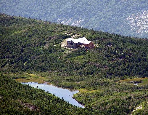
This is a very popular hike and it is usually very crowded on summer weekends. We will be doing this hike on a Wednesday to hopefully avoid the crowds. We will do the "classic" loop, which involves hiking from the parking lot up the Falling Waters Trai to the ridge, then across to Lincoln and Lafayette, then down to the AMC Greenleaf Hut, and from there down the Old Bridle Path back to the parking lot. Bring plenty of water, layers of clothes for the chilly summits, and good sturdy hiking boots.
Rain will cancel.
Directions
We will meet at the Mt. Lafayette Trailhead, on the east side of I-93, where there should be plenty of parking on a Wednesday morning. If the east parking lot is full, you can always park on the west side at the Lafayette Campground. There is a pedestrian tunnel connecting both parking lots.
To reach the east parking lot is fairly easy from I-93. As you head north in the Interstate, just north of Exit 33, you will see that the Interstate enters Franconia Notch State Park, and speeding limits will start to decrease. After you pass the tourist exits for the Flume and the Basin, the road will narrow down to one lane. At that point be very alert, because the trailhead parking will be immediately on your right. It is well marked, so you can't miss it. If you decide to park on the west side, you need to continue traveling north on I-93 up to the Mt. Cannon exit, where you will have to exit and re-enter the southbound lane of I-93. The Lafayette Campground will be on your right, just south of the Mt. Cannon parking area, and the now defunct Old Man of the Mountain.
About this event
The Franconia Ridge Trail is one of the "classic" White Mountain hikes because of the outstanding views from its exposed alpine ridge. It is a fairly strenuous hike, as it covers a total of 8.8 miles, and goes over one four thousand footer (Mt. Little Haystack) and two of the highest peaks in the White Mountains: Mt. Lafayette (5,260') and Mt. Lincoln (5,089'). Little Haystack at 4,780' does not count for the Four Thousand Peakbagging Club, because it is dwarfed by both Lafayette and Lincoln, and yet the ascent to it from the parking area is a whopping 3,000 feet, and thus quite a challenge in it of itself.
This is a very popular hike and it is usually very crowded on summer weekends. We will be doing this hike on a Wednesday to hopefully avoid the crowds. We will do the "classic" loop, which involves hiking from the parking lot up the Falling Waters Trai to the ridge, then across to Lincoln and Lafayette, then down to the AMC Greenleaf Hut, and from there down the Old Bridle Path back to the parking lot. Bring plenty of water, layers of clothes for the chilly summits, and good sturdy hiking boots.
Rain will cancel.
Directions to the trailhead
Get directionsWe will meet at the Mt. Lafayette Trailhead, on the east side of I-93, where there should be plenty of parking on a Wednesday morning. If the east parking lot is full, you can always park on the west side at the Lafayette Campground. There is a pedestrian tunnel connecting both parking lots.
To reach the east parking lot is fairly easy from I-93. As you head north in the Interstate, just north of Exit 33, you will see that the Interstate enters Franconia Notch State Park, and speeding limits will start to decrease. After you pass the tourist exits for the Flume and the Basin, the road will narrow down to one lane. At that point be very alert, because the trailhead parking will be immediately on your right. It is well marked, so you can't miss it. If you decide to park on the west side, you need to continue traveling north on I-93 up to the Mt. Cannon exit, where you will have to exit and re-enter the southbound lane of I-93. The Lafayette Campground will be on your right, just south of the Mt. Cannon parking area, and the now defunct Old Man of the Mountain.
Who's going (4)
 SUSTAINING
  SUSTAINING
  GUEST MEMBER
 Questions about this event?
Reach out to the host, JPHiker, for route details, carpooling, or what to bring.
Email the hostYou can also ask in the event discussion below.
Event discussion
No comments yet.
Log in to join the conversation.