
Mt. Moosilauke via the Beaver Brook
Hike to the summit of Mt. Moosilauke via the Appalachian Trail
Mt. Moosilauke via the Beaver Brook
Hike to the summit of Mt. Moosilauke via the Appalachian Trail
Details
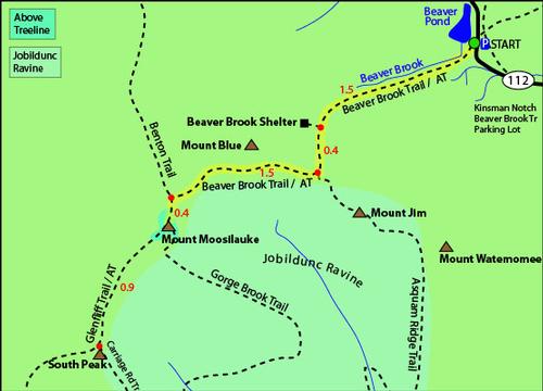
We will be hiking 3.8 somewhat steep miles to the summit of Mt. Moosilauke (4,802') via the Beaver Brook Trail, and return via the easier Benton Trail (3.6 miles) for a total of 7.4 miles. The ascent from the Beaver Brook trailhead involves a 3,100 foot elevation gain. We will keep a moderate pace, with plenty of rest/water stops, but the ascent is fairly steep in parts, and definitely not for the faint of heart. Fortunately, the Dartmouth Outing Club maintains this trail, and in some of the steepest sections they have imbedded re-bar handholds to make footing easier, and safer. It is, however, one of the most beautiful of approaches to the summit. In the early stages of the ascent, we will be bordering the delightful waterfalls of the Beaver Brook, and as we approach the summmit, we will be greeted by a vast alpine region. The views from the top on a clear day are extensive (see photo of summit above). You will able to make out the different peaks of Vermont's Green Mountains (Camel's Hump and Mansfield, in particular), the vast array of NH's White Mountains, and, of course, Canada. The Benton Trail is a very moderate, and thus easier, descent.
Bring plenty of water (2 liters per person is recommended), snacks, and a lunch for the top. As noted above, the summit is very exposed, and even on a warm day, it can be quite chilly up there, so bring layers of clothes to be able to cover up when needed.
Another interesting feature of hiking the Beaver Brook Trail is that this is part of the Appalachian Trail, and we will encounter a few of the AT thru hikers as they make their way into the rugged White Mountains. You should have no problem spotting them, as they will be scruffy, a bit freaked out about their first four thousand footer in New England, but full of energy and good cheer.
Steady or heavy rain will cancel, as the Beaver Brook Trail can get extremely slippery and dangerous.
Directions
We will be spotting cars at the Benton Trailhead, so be at the Beaver Brook Trail rendezvous on time, as it will take about a half hour to accomplish this. Directions to the Beaver Brook Trailhead from I-93 are as follows: Take Exit 32 [Lincoln/Woodstock], and go west on Rt. 112 to the traffic light at Woodstock. Continue straight through the traffic light on Rt. 112 (now called the Lost River Road), and in about 6 miles (at Kinsman Notch) you will see the paved parking lot for the Beaver Brook Trail on your left. On the right side of the road, there is an AT sign (dark brown with the silhoutte of a hiker in yellow). If you see a pond on the left, you've gone too far.
About this event
We will be hiking 3.8 somewhat steep miles to the summit of Mt. Moosilauke (4,802') via the Beaver Brook Trail, and return via the easier Benton Trail (3.6 miles) for a total of 7.4 miles. The ascent from the Beaver Brook trailhead involves a 3,100 foot elevation gain. We will keep a moderate pace, with plenty of rest/water stops, but the ascent is fairly steep in parts, and definitely not for the faint of heart. Fortunately, the Dartmouth Outing Club maintains this trail, and in some of the steepest sections they have imbedded re-bar handholds to make footing easier, and safer. It is, however, one of the most beautiful of approaches to the summit. In the early stages of the ascent, we will be bordering the delightful waterfalls of the Beaver Brook, and as we approach the summmit, we will be greeted by a vast alpine region. The views from the top on a clear day are extensive (see photo of summit above). You will able to make out the different peaks of Vermont's Green Mountains (Camel's Hump and Mansfield, in particular), the vast array of NH's White Mountains, and, of course, Canada. The Benton Trail is a very moderate, and thus easier, descent.
Bring plenty of water (2 liters per person is recommended), snacks, and a lunch for the top. As noted above, the summit is very exposed, and even on a warm day, it can be quite chilly up there, so bring layers of clothes to be able to cover up when needed.
Another interesting feature of hiking the Beaver Brook Trail is that this is part of the Appalachian Trail, and we will encounter a few of the AT thru hikers as they make their way into the rugged White Mountains. You should have no problem spotting them, as they will be scruffy, a bit freaked out about their first four thousand footer in New England, but full of energy and good cheer.
Steady or heavy rain will cancel, as the Beaver Brook Trail can get extremely slippery and dangerous.
Directions to the trailhead
Get directionsWe will be spotting cars at the Benton Trailhead, so be at the Beaver Brook Trail rendezvous on time, as it will take about a half hour to accomplish this. Directions to the Beaver Brook Trailhead from I-93 are as follows: Take Exit 32 [Lincoln/Woodstock], and go west on Rt. 112 to the traffic light at Woodstock. Continue straight through the traffic light on Rt. 112 (now called the Lost River Road), and in about 6 miles (at Kinsman Notch) you will see the paved parking lot for the Beaver Brook Trail on your left. On the right side of the road, there is an AT sign (dark brown with the silhoutte of a hiker in yellow). If you see a pond on the left, you've gone too far.
Who's going (2)

Questions about this event?
Reach out to the host, JPHiker, for route details, carpooling, or what to bring.
Email the hostYou can also ask in the event discussion below.
Event discussion
No comments yet.
Log in to join the conversation.