
Whiteface and Passaconaway Loop Hike
A Classic Loop Hike over the Summits of Mts Whiteface and Passaconaway.
Whiteface and Passaconaway Loop Hike
A Classic Loop Hike over the Summits of Mts Whiteface and Passaconaway.
Details
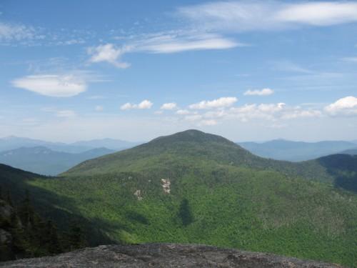
Join me for this 11.5-mile hike over the summits of Mts. Whiteface (4020') and Passaconaway (4043'). While these peaks are rather low on the 4000-footer list they offer ample views into the surrounding wilderness and peaks. On a clear day you will have vistas to the south from Whiteface's ledges, over the Lakes Region and northward to Mt. Washington. There will be additional views along the ridge and off of Mt. Passaconaway. We will be hiking the circuit in a clockwise manner...ascending via the Blueberry Ledge Trail to Whiteface and descending off of Passaconaway by way of the Dicey's Mill Trail. There are moderately steep sections of smooth granite and a few rock scrambles ascending Whiteface, otherwise the trails are modest in grade.
Total Distance and Elevation Gain: 11.5 miles with approximately 4350 feet in cumulative elevation gain.
Total Time: 9 hours depending on breaks and group's speed.
Rain or harsh weather may postpone to another date or cancel, as appropriate.
Camping Option: Contact me, if you're interested in camping Saturday night. I would be happy to set something up or provide details to share my site.
What to Bring: Typical summer hiking gear should be appropriate: convertible hiking pants/shorts, good sturdy hiking boots with thick socks, a windbreaker/raingear. Also bring along lunch, snacks and plenty of water (at least 2-L). Optionally, pack sunscreen and anything else that you may require for a day hike.
Carpooling: Contact other participants to arrange for a rideshare to the trailhead.
Afterwards: If there is sufficient interest, we will have drinks and/or dinner in the area.
Directions
From Route I-93, take Exit 24 for US-3/NH-25 towards Ashland/Holderness. In about 4.5 miles turn left onto NH-113. Continue for 11.7 miles. Turn left onto NH-113 E and proceed for another 3.7 miles. Continue onto NH-113A W/N (Sandwich Road) for 6.7 miles. Here there will be a right-handed bend in the road...DO NOT CONTINUE...Instead turn left onto Ferncroft Road and the marked trailhead parking lot will be on your right. This is about 30 miles (44 minutes) from I-93. Look for a gray Hyundai Elantra.
For GPS Users: Ferncroft Road, Tamworth, NH (43.913584,-71.357972).
About this event
Join me for this 11.5-mile hike over the summits of Mts. Whiteface (4020') and Passaconaway (4043'). While these peaks are rather low on the 4000-footer list they offer ample views into the surrounding wilderness and peaks. On a clear day you will have vistas to the south from Whiteface's ledges, over the Lakes Region and northward to Mt. Washington. There will be additional views along the ridge and off of Mt. Passaconaway. We will be hiking the circuit in a clockwise manner...ascending via the Blueberry Ledge Trail to Whiteface and descending off of Passaconaway by way of the Dicey's Mill Trail. There are moderately steep sections of smooth granite and a few rock scrambles ascending Whiteface, otherwise the trails are modest in grade.
Total Distance and Elevation Gain: 11.5 miles with approximately 4350 feet in cumulative elevation gain.
Total Time: 9 hours depending on breaks and group's speed.
Rain or harsh weather may postpone to another date or cancel, as appropriate.
Camping Option: Contact me, if you're interested in camping Saturday night. I would be happy to set something up or provide details to share my site.
What to Bring: Typical summer hiking gear should be appropriate: convertible hiking pants/shorts, good sturdy hiking boots with thick socks, a windbreaker/raingear. Also bring along lunch, snacks and plenty of water (at least 2-L). Optionally, pack sunscreen and anything else that you may require for a day hike.
Carpooling: Contact other participants to arrange for a rideshare to the trailhead.
Afterwards: If there is sufficient interest, we will have drinks and/or dinner in the area.
Directions to the trailhead
Get directionsFrom Route I-93, take Exit 24 for US-3/NH-25 towards Ashland/Holderness. In about 4.5 miles turn left onto NH-113. Continue for 11.7 miles. Turn left onto NH-113 E and proceed for another 3.7 miles. Continue onto NH-113A W/N (Sandwich Road) for 6.7 miles. Here there will be a right-handed bend in the road...DO NOT CONTINUE...Instead turn left onto Ferncroft Road and the marked trailhead parking lot will be on your right. This is about 30 miles (44 minutes) from I-93. Look for a gray Hyundai Elantra.
For GPS Users: Ferncroft Road, Tamworth, NH (43.913584,-71.357972).
Who's going (2)


Questions about this event?
Reach out to the host, shep5, for route details, carpooling, or what to bring.
Email the hostYou can also ask in the event discussion below.
Event discussion
No comments yet.
Log in to join the conversation.