
A Different Osceolas Traverse
A traverse of the Osceolas using the beautiful and rough Dogleg Slide!
A Different Osceolas Traverse
A traverse of the Osceolas using the beautiful and rough Dogleg Slide!
Details
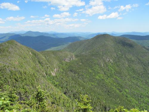
Join me for an adventurous ascent of Mount Osceola using the Dogleg Slide, which forms an impressively large scar on the northern slope. Mount Osceola has an elevation of 4315 feet and is part of the Sandwich Range. The mountain is named for a Native American chief. The summit is a rather large, mostly open granite ledge. East Osceola (4156') is only a mile away along the ridge. This alternative route requires some very minor bushwhacking through mostly open woods between the East Pond Trail and the slide, and from the top of the slide to the summit using a "bootleg" ski trail. The slide provides for constant views northward. Additionally, there are great views on the summit of Osceola, at the "chimney" and from a couple of viewpoints near East Osceola.
Total Distance and Elevation Gain: Approximately 7.5 miles with roughly 3000 feet in cumulative elevation gain.
Total Time: Approximately 7 hours depending on the groups speed and the number of breaks. It is worth noting that climbing the slide may be particularly slow due to its rough and steep nature.
Rain or harsh weather may postpone to another date or cancel, as appropriate.
Camping Option: Contact me, if you're interested in camping Saturday night. I would be happy to set something up or provide details to share my site.
What to Bring: Typical summer hiking gear should be appropriate: convertible hiking pants (highly recommended to prevent your legs from getting scratched up), good sturdy hiking boots with good traction, thick socks, a windbreaker/raingear. Also bring along lunch, snacks and plenty of water (at least 2-L). Optionally, pack sunscreen and anything else that you may require for a day hike.
Carpooling: Contact other participants to arrange for a rideshare to the trailhead.
Afterwards: If there is sufficient interest, we will have drinks and/or dinner in the area.
Directions
From Route 93, get off at Exit 32. At the end of the ramp, turn left onto the Kancamagus Highway (Route 112 East). Travel approximately 9.8 miles to the Greeley Ponds Trailhead.
From the intersection of Routes 113 and 112 in Conway, turn onto Route 112 West (Kancamagus Highway) and travel for 25.4 miles to the Greeley Ponds Trailhead.
Look for a gray Hyundai Elantra. Once assembled, we will carpool to the East Pond Trailhead.
For GPS Users: 44.031683, -71.516731 (Route 112/Kancamagus Highway, Lincoln, NH)
About this event
Join me for an adventurous ascent of Mount Osceola using the Dogleg Slide, which forms an impressively large scar on the northern slope. Mount Osceola has an elevation of 4315 feet and is part of the Sandwich Range. The mountain is named for a Native American chief. The summit is a rather large, mostly open granite ledge. East Osceola (4156') is only a mile away along the ridge. This alternative route requires some very minor bushwhacking through mostly open woods between the East Pond Trail and the slide, and from the top of the slide to the summit using a "bootleg" ski trail. The slide provides for constant views northward. Additionally, there are great views on the summit of Osceola, at the "chimney" and from a couple of viewpoints near East Osceola.
Total Distance and Elevation Gain: Approximately 7.5 miles with roughly 3000 feet in cumulative elevation gain.
Total Time: Approximately 7 hours depending on the groups speed and the number of breaks. It is worth noting that climbing the slide may be particularly slow due to its rough and steep nature.
Rain or harsh weather may postpone to another date or cancel, as appropriate.
Camping Option: Contact me, if you're interested in camping Saturday night. I would be happy to set something up or provide details to share my site.
What to Bring: Typical summer hiking gear should be appropriate: convertible hiking pants (highly recommended to prevent your legs from getting scratched up), good sturdy hiking boots with good traction, thick socks, a windbreaker/raingear. Also bring along lunch, snacks and plenty of water (at least 2-L). Optionally, pack sunscreen and anything else that you may require for a day hike.
Carpooling: Contact other participants to arrange for a rideshare to the trailhead.
Afterwards: If there is sufficient interest, we will have drinks and/or dinner in the area.
Directions to the trailhead
Get directionsFrom Route 93, get off at Exit 32. At the end of the ramp, turn left onto the Kancamagus Highway (Route 112 East). Travel approximately 9.8 miles to the Greeley Ponds Trailhead.
From the intersection of Routes 113 and 112 in Conway, turn onto Route 112 West (Kancamagus Highway) and travel for 25.4 miles to the Greeley Ponds Trailhead.
Look for a gray Hyundai Elantra. Once assembled, we will carpool to the East Pond Trailhead.
For GPS Users: 44.031683, -71.516731 (Route 112/Kancamagus Highway, Lincoln, NH)
Who's going (1)
 GUEST MEMBER
 Questions about this event?
Reach out to the host, shep5, for route details, carpooling, or what to bring.
Email the hostYou can also ask in the event discussion below.
Event discussion
No comments yet.
Log in to join the conversation.