
Mt. Washington via Boott Spurt
FUN hike on this 6,000 footer in the Presidential Range and the highest peak in the Northeast!
Mt. Washington via Boott Spurt
FUN hike on this 6,000 footer in the Presidential Range and the highest peak in the Northeast!
Details
FUN hike on this 6,000 footer in the Presidential Range and the highest peak in the Northeast!
At 6,288 ft. Mt. Washington is the tallest of the NH 4,000 footers and the highest in all of New England and the Northeast. Though the summit is puny compared to other great mountain ranges of the world, Mt. Washington is renowned worldwide for its fierce weather and frequent fatalities. Being the tallest of the peaks, it’s no surprise that the mountain is among the most visited summits in New England. We will ascend up Boott Spur with lunch in the summit cafeteria.
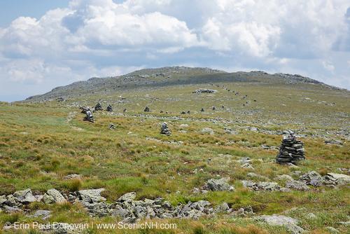
This longer route over the great shoulder of Boott Spur is very scenic! With miles of above treeline walking, it sees far less traffic than Tuckerman Ravine. Much the trail has fairly rough footing. At 2.6 miles will break treeline with impressive views of Tuckerman Headwall. We will be fully exposed to weather until we reach summit using the Crawford Path for a fairly steep climb to the summit cone. Boott Spur summit has excellent views and Bigelow Lawn provides a grand stretch of hiking across an expanse of alpine tundra!
We’ll descend via Lion’s Head Trail. The views of Tuckerman Ravine are outstanding!
Because the hike involves extensive hiking above treeline, attention to safety and the mountain’s notoriously fickle weather is of paramount importance. In addition to safety precautions, you should note that this is arduous climb involving 4,300 elevation gain. It will be 9.6 miles roundtrip. Plan on a finish of 5pm.
Round trip distance: 9.6 miles
Vertical feet: 4,300
Approximate time: 9 hours
What to wear/bring: Wear clothing suitable for the hike in layers...no cotton or blue jeans. Have a rain jacket in the event of inclement weather. Bring along plenty of water (at least 2 liters), lunch [you can buy hot food at the summit], snacks and anything else you may require for a day hike. Contact us if you have any questions.
Boston Area Carpooling: Save money by sharing gas/toll expenses and get to know fellow GO members better! Don't be shy. Contact other Bostonians to find a convenient location for you to meet such as a T-Stop, Commuter Line Stop, or a parking lot of a store familiar to you all! Don't forget to tip the driver!
Afterwards: Bring a change of clothing after the hike as you are welcome to join us for dinner at the Red Fox Grill in Jackson.
Lodging Option: Bunk beds are available at our house [with Wi Fi] near Waterville Valley, NH for Friday and/or Saturday nights. It's $25 for Friday night, $35 for Saturday that includes dinner or $60 for the weekend. Coffee/bagels each morning and linen/blankets/towels are provided. Space is limited so email ASAP to reserve a bunk!
Directions
We will be meeting at the porch at the AMC Pinkham Notch Visitor Center; located on the west side off NH 16 at the height-of-land in Pinkham Notch, 10.6 miles south of US 2 in Gorham and 12 miles north of US 302 in Glen. This is the busiest trailhead in the White Mountains. There is ample parking.
About this event
FUN hike on this 6,000 footer in the Presidential Range and the highest peak in the Northeast!
At 6,288 ft. Mt. Washington is the tallest of the NH 4,000 footers and the highest in all of New England and the Northeast. Though the summit is puny compared to other great mountain ranges of the world, Mt. Washington is renowned worldwide for its fierce weather and frequent fatalities. Being the tallest of the peaks, it’s no surprise that the mountain is among the most visited summits in New England. We will ascend up Boott Spur with lunch in the summit cafeteria.
This longer route over the great shoulder of Boott Spur is very scenic! With miles of above treeline walking, it sees far less traffic than Tuckerman Ravine. Much the trail has fairly rough footing. At 2.6 miles will break treeline with impressive views of Tuckerman Headwall. We will be fully exposed to weather until we reach summit using the Crawford Path for a fairly steep climb to the summit cone. Boott Spur summit has excellent views and Bigelow Lawn provides a grand stretch of hiking across an expanse of alpine tundra!
We’ll descend via Lion’s Head Trail. The views of Tuckerman Ravine are outstanding!
Because the hike involves extensive hiking above treeline, attention to safety and the mountain’s notoriously fickle weather is of paramount importance. In addition to safety precautions, you should note that this is arduous climb involving 4,300 elevation gain. It will be 9.6 miles roundtrip. Plan on a finish of 5pm.
Round trip distance: 9.6 miles
Vertical feet: 4,300
Approximate time: 9 hours
What to wear/bring: Wear clothing suitable for the hike in layers...no cotton or blue jeans. Have a rain jacket in the event of inclement weather. Bring along plenty of water (at least 2 liters), lunch [you can buy hot food at the summit], snacks and anything else you may require for a day hike. Contact us if you have any questions.
Boston Area Carpooling: Save money by sharing gas/toll expenses and get to know fellow GO members better! Don't be shy. Contact other Bostonians to find a convenient location for you to meet such as a T-Stop, Commuter Line Stop, or a parking lot of a store familiar to you all! Don't forget to tip the driver!
Afterwards: Bring a change of clothing after the hike as you are welcome to join us for dinner at the Red Fox Grill in Jackson.
Lodging Option: Bunk beds are available at our house [with Wi Fi] near Waterville Valley, NH for Friday and/or Saturday nights. It's $25 for Friday night, $35 for Saturday that includes dinner or $60 for the weekend. Coffee/bagels each morning and linen/blankets/towels are provided. Space is limited so email ASAP to reserve a bunk!
Directions to the trailhead
Get directionsWe will be meeting at the porch at the AMC Pinkham Notch Visitor Center; located on the west side off NH 16 at the height-of-land in Pinkham Notch, 10.6 miles south of US 2 in Gorham and 12 miles north of US 302 in Glen. This is the busiest trailhead in the White Mountains. There is ample parking.
Who's going (3)

Questions about this event?
Reach out to the host, Gandalf, for route details, carpooling, or what to bring.
Email the hostYou can also ask in the event discussion below.
Event discussion
No comments yet.
Log in to join the conversation.