
Art Loeb Trail / Clingmans Dome
Art Loeb Trail / Clingmans Dome
Details
I have made Travel Plans from Florida to Asheville NC Jun 17-24th. I am planning two (2) separate backpack camping hikes – each (1) overnight & each approx. 10 miles or less total roundtrip & minimum elevation changes.
ALL PLANNING WOULD HAVE TO BE DIRECT WITH ME AS THIS IS TWO WEEKS OUT & I'M TRAVELLING FROM 800 MILES AWAY. IF SO INTERESTED WE CAN TALK DIRECT AS TO WHEN WHERE & HOW TO MEETUP. E-MAIL ME YOUR NUMBER & WE'LL TALK.
TRIP 1: Jun 18-19: Art Loeb Trail from Black Balsam Road (MP 420 on the Blue Ridge Parkway) to Shining Rock Mountain. Elevation begins at 5800 ft. & rises to 6200 ft. & dips to 5600 ft.
TUESDAY JUNE 20 – REST DAY BACK AT THE HOTEL.
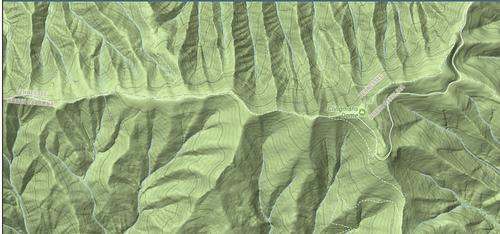
TRIP 2: Jun 21-22. Clingman's Dome along the Appalachian Trail to shelter at Silers Bald – staying on the ridgeline of the highest point in Tennessee.
Both these hikes are familiar & popular (at least to locals I'm sure). Links below for better detailed descriptions of the trail & terrain & hike. ME: I have extensive day-hiking & camping experience but limited backpack/hiking and believe I have the resources & stamina to complete these as planned. It's something I stumbled across & would like to say someday I completed. So, I've planned moderate to strenuous distance – 5 miles one way on each of 4 days. In/Out 2X. One overnight. Minimum elevation – although Art Loeb goes Up/Down 200ft 2+ times each direction.
I apologize for the short notice. I was all set to go in May by the rains came. And they may still come – hopefully there will be more sun than not.
Art Loeb Trail to Shining Rock Mountain: https://ashevilletrails.com/shining-rock-wilderness/shining-rock-art-loeb-trail/#directions
Clingman's Dome along the Appalachian Trail: use the map at the same link to scroll to the Trail Head. Zoom out then north & west.
Directions
ALL PLANNING WOULD HAVE TO BE DIRECT WITH ME AS THIS IS TWO WEEKS OUT & I'M TRAVELLING FROM 800 MILES AWAY. IF SO INTERESTED WE CAN TALK DIRECT AS TO WHEN WHERE & HOW TO MEETUP. E-MAIL ME YOUR NUMBER & WE'LL TALK.
About this event
I have made Travel Plans from Florida to Asheville NC Jun 17-24th. I am planning two (2) separate backpack camping hikes – each (1) overnight & each approx. 10 miles or less total roundtrip & minimum elevation changes.
ALL PLANNING WOULD HAVE TO BE DIRECT WITH ME AS THIS IS TWO WEEKS OUT & I'M TRAVELLING FROM 800 MILES AWAY. IF SO INTERESTED WE CAN TALK DIRECT AS TO WHEN WHERE & HOW TO MEETUP. E-MAIL ME YOUR NUMBER & WE'LL TALK.
TRIP 1: Jun 18-19: Art Loeb Trail from Black Balsam Road (MP 420 on the Blue Ridge Parkway) to Shining Rock Mountain. Elevation begins at 5800 ft. & rises to 6200 ft. & dips to 5600 ft.
TUESDAY JUNE 20 – REST DAY BACK AT THE HOTEL.
TRIP 2: Jun 21-22. Clingman's Dome along the Appalachian Trail to shelter at Silers Bald – staying on the ridgeline of the highest point in Tennessee.
Both these hikes are familiar & popular (at least to locals I'm sure). Links below for better detailed descriptions of the trail & terrain & hike. ME: I have extensive day-hiking & camping experience but limited backpack/hiking and believe I have the resources & stamina to complete these as planned. It's something I stumbled across & would like to say someday I completed. So, I've planned moderate to strenuous distance – 5 miles one way on each of 4 days. In/Out 2X. One overnight. Minimum elevation – although Art Loeb goes Up/Down 200ft 2+ times each direction.
I apologize for the short notice. I was all set to go in May by the rains came. And they may still come – hopefully there will be more sun than not.
Art Loeb Trail to Shining Rock Mountain: https://ashevilletrails.com/shining-rock-wilderness/shining-rock-art-loeb-trail/#directions
Clingman's Dome along the Appalachian Trail: use the map at the same link to scroll to the Trail Head. Zoom out then north & west.
Directions to the trailhead
Get directions Opens turn-by-turn directions to Asheville, NC, 28801 in Google Maps (new tab).
ALL PLANNING WOULD HAVE TO BE DIRECT WITH ME AS THIS IS TWO WEEKS OUT & I'M TRAVELLING FROM 800 MILES AWAY. IF SO INTERESTED WE CAN TALK DIRECT AS TO WHEN WHERE & HOW TO MEETUP. E-MAIL ME YOUR NUMBER & WE'LL TALK.
Who's going (1)
A member
Profile hidden
Questions about this event?
Questions for the host, trekkr, about route details, carpooling, or what to bring? Ask in the event discussion below.
Event discussion
No comments yet.
Log in to join the conversation.