
Mt. Jefferson via Castle Trail
FUN hike on this 5,000 footer in the Presidential Range followed by a swim/BBQ at the Mad River Lodge!
Mt. Jefferson via Castle Trail
FUN hike on this 5,000 footer in the Presidential Range followed by a swim/BBQ at the Mad River Lodge!
Details
FUN hike on this 5,000 footer in the Presidential Range followed by a swim/BBQ at the Mad River Lodge!
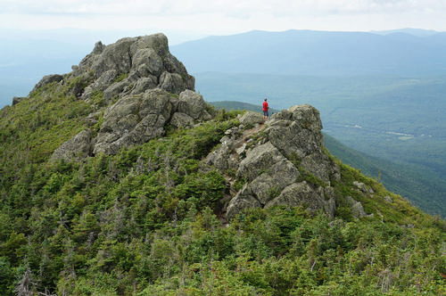
Mt. Jefferson, [5,716'], the third highest peak in the Whites grants a sweeping view, though a bit less inspiring than that from neighboring Mt. Adams. The summit reveals a wide expanse of the western Whites and an interesting oblique view of the Southern Presidentials.
Round trip distance: 10.8 miles
Vertical feet: 4,200
Approximate time: 8 hours
We will ascend up the long but highly rewarding approach up the Castellated Ridge, with terrific views and some tough scrambling along the Castles, and the usual rock-hop above treeline! At 1.3 miles we’ll reach the Israel Ridge Path where we begin to steadily climb up. At 2.5 miles we reach a level shoulder and climb once more reaching the Link Trail at 3.5 miles. The Castle Trail will then become steep and rough, with several fairly challenging scrambles up ledges and boulders with open views. At 4.5 miles we reach the Cornice Trail and in another half mile reach the summit of Mt. Jefferson. We will return using the trails on the northeast side of Castle Ravine [Randolph Path and Israel Ridge Path], with a short side trip to great views of the ravine at Emerald Bluff! There is 4,200 feet of elevation gain in about 4 miles of steady climbing. Total mileage up and back is 10.8 miles.
The upper cone of the mountain is a jumble of broken rock, devoid of trees and any protection from the elements. We are allowing a full day for this very strenuous climb, which includes difficult boulder-hopping on the upper ridges.
What to wear/bring: Wear clothing suitable for the hike in layers...no cotton or blue jeans. Have a rain jacket in the event of inclement weather. Bring along plenty of water (at least 2 liters), lunch, snacks and anything else you may require for a day hike. Contact us if you have any questions.
Boston Area Carpooling: Save money by sharing gas/toll expenses and get to know fellow GO members better! Don't be shy. Contact other Bostonians to find a convenient location for you to meet such as a T-Stop, Commuter Line Stop, or a parking lot of a store familiar to you all! Don't forget to tip the driver!
Afterwards: Everyone is welcome to join us back at our house in Waterville Valley to relax by our fireplace [BYOB and bring snacks] followed by one of Jon's delicious dinners. We ask $10 per person to help pay for our food costs. Showers are available so bring a change of clothing to make your visit with us more comfortable.
Lodging Option: Bunk beds are available at our house [with Wi Fi] near Waterville Valley, NH for Friday and/or Saturday nights. It's $25 for Friday night, $35 for Saturday that includes dinner or $60 for the weekend. Coffee/bagels each morning and linen/blankets/towels are provided. Space is limited so email ASAP to reserve a bunk!
Directions
The Castle Trail begins at Bowman on US 3, 3 miles west of the Appalachia parking area and 4.2 miles east of the junction of US 2 and NH 115. We are driving a blue Toyota Tacoma truck.
About this event
FUN hike on this 5,000 footer in the Presidential Range followed by a swim/BBQ at the Mad River Lodge!
Mt. Jefferson, [5,716'], the third highest peak in the Whites grants a sweeping view, though a bit less inspiring than that from neighboring Mt. Adams. The summit reveals a wide expanse of the western Whites and an interesting oblique view of the Southern Presidentials.
Round trip distance: 10.8 miles
Vertical feet: 4,200
Approximate time: 8 hours
We will ascend up the long but highly rewarding approach up the Castellated Ridge, with terrific views and some tough scrambling along the Castles, and the usual rock-hop above treeline! At 1.3 miles we’ll reach the Israel Ridge Path where we begin to steadily climb up. At 2.5 miles we reach a level shoulder and climb once more reaching the Link Trail at 3.5 miles. The Castle Trail will then become steep and rough, with several fairly challenging scrambles up ledges and boulders with open views. At 4.5 miles we reach the Cornice Trail and in another half mile reach the summit of Mt. Jefferson. We will return using the trails on the northeast side of Castle Ravine [Randolph Path and Israel Ridge Path], with a short side trip to great views of the ravine at Emerald Bluff! There is 4,200 feet of elevation gain in about 4 miles of steady climbing. Total mileage up and back is 10.8 miles.
The upper cone of the mountain is a jumble of broken rock, devoid of trees and any protection from the elements. We are allowing a full day for this very strenuous climb, which includes difficult boulder-hopping on the upper ridges.
What to wear/bring: Wear clothing suitable for the hike in layers...no cotton or blue jeans. Have a rain jacket in the event of inclement weather. Bring along plenty of water (at least 2 liters), lunch, snacks and anything else you may require for a day hike. Contact us if you have any questions.
Boston Area Carpooling: Save money by sharing gas/toll expenses and get to know fellow GO members better! Don't be shy. Contact other Bostonians to find a convenient location for you to meet such as a T-Stop, Commuter Line Stop, or a parking lot of a store familiar to you all! Don't forget to tip the driver!
Afterwards: Everyone is welcome to join us back at our house in Waterville Valley to relax by our fireplace [BYOB and bring snacks] followed by one of Jon's delicious dinners. We ask $10 per person to help pay for our food costs. Showers are available so bring a change of clothing to make your visit with us more comfortable.
Lodging Option: Bunk beds are available at our house [with Wi Fi] near Waterville Valley, NH for Friday and/or Saturday nights. It's $25 for Friday night, $35 for Saturday that includes dinner or $60 for the weekend. Coffee/bagels each morning and linen/blankets/towels are provided. Space is limited so email ASAP to reserve a bunk!
Directions to the trailhead
Get directionsThe Castle Trail begins at Bowman on US 3, 3 miles west of the Appalachia parking area and 4.2 miles east of the junction of US 2 and NH 115. We are driving a blue Toyota Tacoma truck.
Who's going (5)


Questions about this event?
Reach out to the host, Gandalf, for route details, carpooling, or what to bring.
Email the hostYou can also ask in the event discussion below.
Event discussion
No comments yet.
Log in to join the conversation.