
Thursday Kayak Lake Umbagog N.W.R.
Weekday Paddle Lake Umbagog NWR
Details
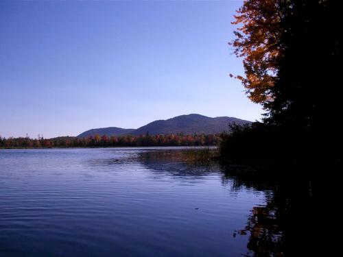
Always a last minute guy, I thought I'd offer up a weekday (Thurs) paddle on Lake Umbagog National Wildlife Refuge -straddling the ME / NH border. There are two put in options, depending on the # of people interested. We'll be exploring the quieter, northern section of the lake, probably paddling 6-8 miles. Pack a lunch and maybe find a spot for a final lake swim of summer? (No promises here, because if I remember correctly, while the water is clear the bottom is somewhat boggy...but maybe we can find a rock / ledge to swim off of. There are a couple of primitive campsites to explore for future reference, but for now only a day trip is planned. I have a couple (2) of SPARE kayaks, I could bring if you're boatless (let me know). The lake is large and at times can be windy / white caps so, for this reason and the distance, I don't think this is a trip for you if you're new to kayaking. I'm happy to offer some beginners' paddles if there's interest. Maybe a post paddle beer somewhere? This will be a fair weather paddle, though the wind situation is unpredictable.
Directions
From Bethel, ME take Rt 26 North THROUGH Grafton Notch State Park into Errol, NH. There's more parking at the dam, so we'll plan on meeting there, but if our numbers are small we can cut out some paddling by putting in a couple of miles further down the road (where parking is more limited). For now, we'll plan on the DAM meeting site, which is located just SOUTH of where RT 26 crosses the ANDROSCOGGIN River. If you cross the river, and enter "downtown" Errol, you've gone TOO FAR. Turn RIGHT just before the river crossing onto a dirt road called N. Mountain Pond Rd (there should be a sign for public water access). After a short distance bear Left onto Boat Landing Rd which dead ends at the dam parking lot. Don't be fooled by your first lake view / boatlaunch /picnic area on RT 26 which is on the southern tip of the lake, we'll be exploring the northern section, a few miles further down RT 26.
About this event
Always a last minute guy, I thought I'd offer up a weekday (Thurs) paddle on Lake Umbagog National Wildlife Refuge -straddling the ME / NH border. There are two put in options, depending on the # of people interested. We'll be exploring the quieter, northern section of the lake, probably paddling 6-8 miles. Pack a lunch and maybe find a spot for a final lake swim of summer? (No promises here, because if I remember correctly, while the water is clear the bottom is somewhat boggy...but maybe we can find a rock / ledge to swim off of. There are a couple of primitive campsites to explore for future reference, but for now only a day trip is planned. I have a couple (2) of SPARE kayaks, I could bring if you're boatless (let me know). The lake is large and at times can be windy / white caps so, for this reason and the distance, I don't think this is a trip for you if you're new to kayaking. I'm happy to offer some beginners' paddles if there's interest. Maybe a post paddle beer somewhere? This will be a fair weather paddle, though the wind situation is unpredictable.
Directions to the trailhead
Get directionsFrom Bethel, ME take Rt 26 North THROUGH Grafton Notch State Park into Errol, NH. There's more parking at the dam, so we'll plan on meeting there, but if our numbers are small we can cut out some paddling by putting in a couple of miles further down the road (where parking is more limited). For now, we'll plan on the DAM meeting site, which is located just SOUTH of where RT 26 crosses the ANDROSCOGGIN River. If you cross the river, and enter "downtown" Errol, you've gone TOO FAR. Turn RIGHT just before the river crossing onto a dirt road called N. Mountain Pond Rd (there should be a sign for public water access). After a short distance bear Left onto Boat Landing Rd which dead ends at the dam parking lot. Don't be fooled by your first lake view / boatlaunch /picnic area on RT 26 which is on the southern tip of the lake, we'll be exploring the northern section, a few miles further down RT 26.
Who's going (2)
 GUEST MEMBER
  GUEST MEMBER
 Questions about this event?
Reach out to the host, otherportland, for route details, carpooling, or what to bring.
Email the hostYou can also ask in the event discussion below.
Event discussion
Log in to join the conversation.