
Peak Foliage Stratton Mt. Hike
Columbus Day weekend loop hike in scenic southern VT, optional camping
Peak Foliage Stratton Mt. Hike
Columbus Day weekend loop hike in scenic southern VT, optional camping
Details
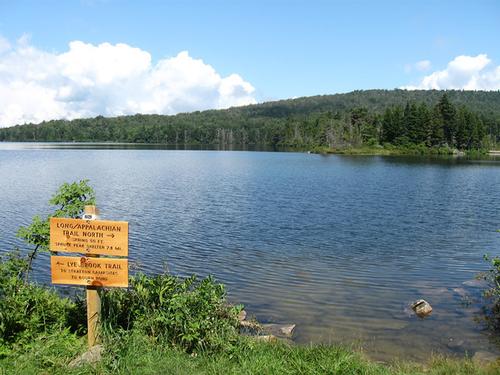
Stratton Mountain lies in the heart of the Green Mountains with a fire tower offering 360 panoramic views. The hike is long at about 11 miles, but the trail is not difficult with only moderate elevation gain (about 1700 feet). Fall colors should be close to their peak. From the trail head on Stratton-Arlington road, we’ll follow the AT/LT to the summit of Stratton Mt., then descend the AT/LT to Stratton Pond, a remote picturesque pond. The mostly flat Stratton Pond Trail will take us back to the Stratton-Arlington road and a 1 mile (gravel) road walk back to the parking area finishes the hike. Pack a lunch, snacks and water. Weather may be chilly in the morning to comfortably warm in the afternoon. Dress appropriately in layers.
Optional Camping: I have reserved a lean-to at Molly Stark State Park for the entire Columbus Day weekend (3 nights). If you like to camp for all or part of the weekend, let me know and I will help coordinate sharing of campsites. However, you are responsible for making your own reservation.
Directions
Using a GPS: 1376 Stratton-Arlington Rd., Stratton, VT or the coordinates 43.061041, -72.967717. Take exit 2 on I-91 in VT. Follow VT-9 West To Wilmington (VT-100 joins VT-9 just before Wilmington). Turn right in the center of Wilmington to stay on VT-100. Follow VT-100 for 13.9 miles. Turn left on Stratton-Arlington Rd. The LT/AT parking lot and trail head will be on your right after 6.8 miles.
About this event
Stratton Mountain lies in the heart of the Green Mountains with a fire tower offering 360 panoramic views. The hike is long at about 11 miles, but the trail is not difficult with only moderate elevation gain (about 1700 feet). Fall colors should be close to their peak. From the trail head on Stratton-Arlington road, we’ll follow the AT/LT to the summit of Stratton Mt., then descend the AT/LT to Stratton Pond, a remote picturesque pond. The mostly flat Stratton Pond Trail will take us back to the Stratton-Arlington road and a 1 mile (gravel) road walk back to the parking area finishes the hike. Pack a lunch, snacks and water. Weather may be chilly in the morning to comfortably warm in the afternoon. Dress appropriately in layers.
Optional Camping: I have reserved a lean-to at Molly Stark State Park for the entire Columbus Day weekend (3 nights). If you like to camp for all or part of the weekend, let me know and I will help coordinate sharing of campsites. However, you are responsible for making your own reservation.
Directions to the trailhead
Get directionsUsing a GPS: 1376 Stratton-Arlington Rd., Stratton, VT or the coordinates 43.061041, -72.967717. Take exit 2 on I-91 in VT. Follow VT-9 West To Wilmington (VT-100 joins VT-9 just before Wilmington). Turn right in the center of Wilmington to stay on VT-100. Follow VT-100 for 13.9 miles. Turn left on Stratton-Arlington Rd. The LT/AT parking lot and trail head will be on your right after 6.8 miles.
Who's going (5)
 GUEST MEMBER
  GUEST MEMBER
  SUSTAINING
  GUEST MEMBER
 Questions about this event?
Reach out to the host, wildcat, for route details, carpooling, or what to bring.
Email the hostYou can also ask in the event discussion below.
Event discussion
Log in to join the conversation.