
Dry River Wilderness Backpack
A 2-Day Backpack into the Dry River Wilderness, taking in Mts Isolation and Jackson, as well as the Webster Cliffs.
Dry River Wilderness Backpack
A 2-Day Backpack into the Dry River Wilderness, taking in Mts Isolation and Jackson, as well as the Webster Cliffs.
Details
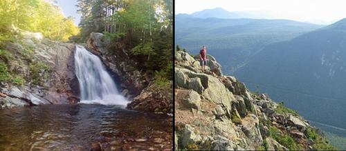
Please join me for an exciting backcountry experience into the primative Dry River Wilderness. On Saturday we will hike up the Dry River Trail and ascend Mt. Isolation from the west. Mount Isolation is ranked low on the 4000-footer list at an elevation of only 4003 feet. Still it offers splendid views of the southern Presidential Range including Mount Washington. We will descend off of the Montalban Ridge again to spend the night at a primative tent site in the Dry River Wilderness. A short distance from the trail junctions is the beautiful Dry River Falls, which has a wonderful pool for swimming and may be a welcome way to end the day. On Sunday, we will climb up to the Mizpah AMC Hut using the Dry River Cutoff and turn south for the ascent of Mt. Jackson (4052'). We'll complete the loop by continuing on to Mt. Webster (3910') and descend via the dramatic Webster Cliff. This route should offer a little of everything with a a visit to a beautiful waterfalls and plenty of views from the valley and from the open summits and ledges.
NOTE: The Dry River Trail was severely damaged by Hurricane Irene. The trail is minimally maintained and left as a primative trail, which is rough and rocky in spots. It has been seriously eroded in areas and routed around a few landslides. Fording of the river will also be necessary.
Total Distance and Elevation Gain: 23.4 miles with approximately 4450 feet in cumulative elevation gain. This breaks down to 12.1 miles and 2790' for Day 1 and 11.3 miles and 1660' for Day 2.
Rain or harsh weather may postpone to another date or cancel, as appropriate.
What to Bring: You will need a pack, tent/bivy, sleeping bag/pad, extra dry clothes/towel, food for 2 lunches, 1 dinner and 1 breakfast, headlamp, bear bag/cannister, camp stove, water filter, etc. (some double up is possible for shared equipment...tents, bear bags, stoves, water filter). Typical summer hiking gear should be appropriate: convertible hiking pants, good sturdy hiking boots with thick socks and a windbreaker/raingear (just in case). Snacks and at least 2 liters of water (water can be filtered along the way and from the hut). Optionally, pack bug repellent and sunscreen and anything else that you may require for a multi-day hike. Also consider bringing a swim suit, if you'd like to swim at Dry River Falls (officially public nudity is prohibited within the WMNF, but I don't know if it's ever been enforced).
Carpooling: Contact other participants or the trip leader to arrange for a rideshare to the trailhead.
Afterwards: If there is sufficient interest, we will have drinks and/or dinner before leaving the area on Sunday afternoon.
Directions
The trailhead parking is a small pull-off, which affords roadside parking for a few cars on the east side of US Rt. 302, 0.3 miles north of the Dry River Campground. This is approximately 13.8 miles heading east from the intersection of Routes 3 and 302 in Twin Mountain. It is also approximately 15.3 miles heading west from the intersection of Routes 16 and 302 in Intervale.
For GPS Users: 44.158742, -71.365003 (Crawford Notch Road/Route 302, Bartlett, NH)
About this event
Please join me for an exciting backcountry experience into the primative Dry River Wilderness. On Saturday we will hike up the Dry River Trail and ascend Mt. Isolation from the west. Mount Isolation is ranked low on the 4000-footer list at an elevation of only 4003 feet. Still it offers splendid views of the southern Presidential Range including Mount Washington. We will descend off of the Montalban Ridge again to spend the night at a primative tent site in the Dry River Wilderness. A short distance from the trail junctions is the beautiful Dry River Falls, which has a wonderful pool for swimming and may be a welcome way to end the day. On Sunday, we will climb up to the Mizpah AMC Hut using the Dry River Cutoff and turn south for the ascent of Mt. Jackson (4052'). We'll complete the loop by continuing on to Mt. Webster (3910') and descend via the dramatic Webster Cliff. This route should offer a little of everything with a a visit to a beautiful waterfalls and plenty of views from the valley and from the open summits and ledges.
NOTE: The Dry River Trail was severely damaged by Hurricane Irene. The trail is minimally maintained and left as a primative trail, which is rough and rocky in spots. It has been seriously eroded in areas and routed around a few landslides. Fording of the river will also be necessary.
Total Distance and Elevation Gain: 23.4 miles with approximately 4450 feet in cumulative elevation gain. This breaks down to 12.1 miles and 2790' for Day 1 and 11.3 miles and 1660' for Day 2.
Rain or harsh weather may postpone to another date or cancel, as appropriate.
What to Bring: You will need a pack, tent/bivy, sleeping bag/pad, extra dry clothes/towel, food for 2 lunches, 1 dinner and 1 breakfast, headlamp, bear bag/cannister, camp stove, water filter, etc. (some double up is possible for shared equipment...tents, bear bags, stoves, water filter). Typical summer hiking gear should be appropriate: convertible hiking pants, good sturdy hiking boots with thick socks and a windbreaker/raingear (just in case). Snacks and at least 2 liters of water (water can be filtered along the way and from the hut). Optionally, pack bug repellent and sunscreen and anything else that you may require for a multi-day hike. Also consider bringing a swim suit, if you'd like to swim at Dry River Falls (officially public nudity is prohibited within the WMNF, but I don't know if it's ever been enforced).
Carpooling: Contact other participants or the trip leader to arrange for a rideshare to the trailhead.
Afterwards: If there is sufficient interest, we will have drinks and/or dinner before leaving the area on Sunday afternoon.
Directions to the trailhead
Get directionsThe trailhead parking is a small pull-off, which affords roadside parking for a few cars on the east side of US Rt. 302, 0.3 miles north of the Dry River Campground. This is approximately 13.8 miles heading east from the intersection of Routes 3 and 302 in Twin Mountain. It is also approximately 15.3 miles heading west from the intersection of Routes 16 and 302 in Intervale.
For GPS Users: 44.158742, -71.365003 (Crawford Notch Road/Route 302, Bartlett, NH)
Who's going (2)


Questions about this event?
Reach out to the host, shep5, for route details, carpooling, or what to bring.
Email the hostYou can also ask in the event discussion below.
Event discussion
No comments yet.
Log in to join the conversation.