
Mount Jefferson Loop Hike
A Loop Hike over Mt Jefferson Encompassing the Spectacular "Castles" and Caps Ridges.
Mount Jefferson Loop Hike
A Loop Hike over Mt Jefferson Encompassing the Spectacular "Castles" and Caps Ridges.
Details
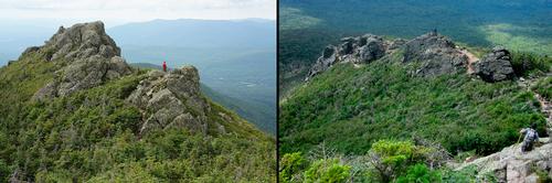
Mount Jefferson is the third highest mountain in NH and also in the Northeast. It sits at an elevation of 5712 feet and is part of the Presidential Range. The mountain is made up of several interesting geological features. First, there are two distinct ridges, which lead to its summit: the Castle Ridge and Ridge of the Caps. Second, there are a few dramatic glacial cirques which surround it: Jefferson Ravine, Castle Ravine and the Great Gulf. We will hike the Caps Ridge Trail from the trailhead on Jefferson Notch Road to the Link Trail. This trail will take us to the base of the "Castles", where we will ascend Mt. Jefferson. On the return we will utilize the Caps Ridge Trail all the way back. There are spectacular, nearly constant views along the ridges and up on the summit. This is a rugged, rocky hike with a few short, steep scrambles.
Distance and elevation gain: 6.7 miles and approximately 2900 feet in cumulative elevation gain.
Total Time: 5-6 hours depending on breaks and group's speed.
Rain or harsh weather may postpone to another date or cancel, as appropriate.
What to Bring: Typical spring hiking gear should be appropriate: convertible hiking pants, good sturdy hiking boots with thick socks, a windbreaker/raingear and extra layers (e.g. fleece). Also bring along lunch, snacks and plenty of water (at least 2-L). Optionally, pack sunscreen and anything else that you may require for a day hike.
Carpooling: Contact other participants or the trip leader to arrange for a rideshare to the trailhead.
Camping Option: Contact me, if you're interested in camping Saturday night. I would be happy to coordinate a campsite or provide details to share my site.
Afterwards: If there is sufficient interest, we will have drinks and/or dinner in the area.
Directions
From the intersection of Routes 3 and 302 in Twin Mountain, turn right onto Route 302 East and follow for 4.4 miles. Just past Faybian's Restaurant in the old rail station, turn left onto Base Station Road. Follow this for 4.4 miles to Jefferson Notch Road. It will be on your left. Follow Jefferson Notch Road for 3.2 miles to the trailhead, which will have a parking lot on your right. Look for a gray Hyundai Elantra. NOTE: Jefferson Notch Road is narrow and may be rough. It usually is in decent condition, but may be slow.
GPS Users: 44.296884, -71.354226 (Jefferson Notch Road; Randolph, NH)
About this event
Mount Jefferson is the third highest mountain in NH and also in the Northeast. It sits at an elevation of 5712 feet and is part of the Presidential Range. The mountain is made up of several interesting geological features. First, there are two distinct ridges, which lead to its summit: the Castle Ridge and Ridge of the Caps. Second, there are a few dramatic glacial cirques which surround it: Jefferson Ravine, Castle Ravine and the Great Gulf. We will hike the Caps Ridge Trail from the trailhead on Jefferson Notch Road to the Link Trail. This trail will take us to the base of the "Castles", where we will ascend Mt. Jefferson. On the return we will utilize the Caps Ridge Trail all the way back. There are spectacular, nearly constant views along the ridges and up on the summit. This is a rugged, rocky hike with a few short, steep scrambles.
Distance and elevation gain: 6.7 miles and approximately 2900 feet in cumulative elevation gain.
Total Time: 5-6 hours depending on breaks and group's speed.
Rain or harsh weather may postpone to another date or cancel, as appropriate.
What to Bring: Typical spring hiking gear should be appropriate: convertible hiking pants, good sturdy hiking boots with thick socks, a windbreaker/raingear and extra layers (e.g. fleece). Also bring along lunch, snacks and plenty of water (at least 2-L). Optionally, pack sunscreen and anything else that you may require for a day hike.
Carpooling: Contact other participants or the trip leader to arrange for a rideshare to the trailhead.
Camping Option: Contact me, if you're interested in camping Saturday night. I would be happy to coordinate a campsite or provide details to share my site.
Afterwards: If there is sufficient interest, we will have drinks and/or dinner in the area.
Directions to the trailhead
Get directionsFrom the intersection of Routes 3 and 302 in Twin Mountain, turn right onto Route 302 East and follow for 4.4 miles. Just past Faybian's Restaurant in the old rail station, turn left onto Base Station Road. Follow this for 4.4 miles to Jefferson Notch Road. It will be on your left. Follow Jefferson Notch Road for 3.2 miles to the trailhead, which will have a parking lot on your right. Look for a gray Hyundai Elantra. NOTE: Jefferson Notch Road is narrow and may be rough. It usually is in decent condition, but may be slow.
GPS Users: 44.296884, -71.354226 (Jefferson Notch Road; Randolph, NH)
Who's going (11)
 GUEST MEMBER
  GUEST MEMBER
  SUSTAINING
  GUEST MEMBER
  GUEST MEMBER
  GUEST MEMBER
  GUEST MEMBER
  SUSTAINING
  GUEST MEMBER
 Questions about this event?
Reach out to the host, shep5, for route details, carpooling, or what to bring.
Email the hostYou can also ask in the event discussion below.
Event discussion
Log in to join the conversation.