
Lafayette, Lincoln and Owl's Head Hike
A Hike to Owl's Head from Franconia Ridge using the old Lincoln Slide Trail.
Lafayette, Lincoln and Owl's Head Hike
A Hike to Owl's Head from Franconia Ridge using the old Lincoln Slide Trail.
Details
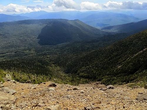
Join me for this hearty hike to three 4000-footers...Mt. Lafayette (5260'), Mt. Lincoln (5089') and Owl's Head (4025'). While this may seem like an unusual combination of mountains, there used to be a trail connecting the Franconia Ridge with Owl's Head. The Lincoln Slide Trail was originally blazed in 1949 and it was still mentioned in the 1960 AMC White Mountain Guide. While the trail has been abandoned, the slide still presents the more adventurous soul with a more scenic route to Owl's Head. There is some minor bushwhacking to get from the Lincoln-Lafayette col to the top of the slide. The bottom of the slide out to the Lincoln Brook Trail is reportably through open woods. The hike up to Owl's Head is via a small slide and herd path. On the return, we'll hike back to Lincoln Woods via the picturesque Black Pond to cut out some mileage (mostly open woods, but with some wet areas). There will be fantastic views from the Bridle Path, the open ridgeline and along the Lincoln Slide.
Distance and elevation gain: About 16.5 - 17.0 miles and approximately 4985 feet in cumulative elevation gain. NOTE: The typical Owl's Head hike alone is 18.2 miles with 2550 feet. This hike is shorter, but with twice the elevation. The last 6.5 miles back to Lincoln Woods are a relatively easy walk through the woods though.
Total Time: 10-11 hours depending on breaks and group's speed.
Rain or harsh weather may postpone to another date or cancel, as appropriate.
What to Bring: Typical spring hiking gear should be appropriate: convertible hiking pants, good sturdy hiking boots with thick socks, a windbreaker/raingear and extra layers (e.g. fleece). Also bring along lunch, snacks and plenty of water (at least 2-L). Optionally, pack sunscreen and anything else that you may require for a day hike.
Carpooling: Contact other participants or the trip leader to arrange for a rideshare to the trailhead.
Afterwards: If there is sufficient interest, we will have drinks and/or dinner in the area.
Directions
From Routes 93, take Exit 32 for Lincoln: At the end of the ramp, take a left onto Route 112 East (Kancamagus Highway) and travel for 5.1 miles to the Lincoln Woods parking lot. It will be signed and on the left.
From the intersection of Routes 113 and 112 in Conway, travel 30 miles west on Route 112 (Kancamagus Highway) to the Lincoln Woods parking lot. It will be signed and on the right.
It's a rather large parking lot, but look for a Hyundai Elantra (with me standing nearby).
Once we're all together, we will carpool up to the Lafayette Place Trailhead (Bridle Path/Falling Waters).
GPS Users: 44.063449, -71.589189 (Kancamagus Highway; Licoln, NH)
About this event
Join me for this hearty hike to three 4000-footers...Mt. Lafayette (5260'), Mt. Lincoln (5089') and Owl's Head (4025'). While this may seem like an unusual combination of mountains, there used to be a trail connecting the Franconia Ridge with Owl's Head. The Lincoln Slide Trail was originally blazed in 1949 and it was still mentioned in the 1960 AMC White Mountain Guide. While the trail has been abandoned, the slide still presents the more adventurous soul with a more scenic route to Owl's Head. There is some minor bushwhacking to get from the Lincoln-Lafayette col to the top of the slide. The bottom of the slide out to the Lincoln Brook Trail is reportably through open woods. The hike up to Owl's Head is via a small slide and herd path. On the return, we'll hike back to Lincoln Woods via the picturesque Black Pond to cut out some mileage (mostly open woods, but with some wet areas). There will be fantastic views from the Bridle Path, the open ridgeline and along the Lincoln Slide.
Distance and elevation gain: About 16.5 - 17.0 miles and approximately 4985 feet in cumulative elevation gain. NOTE: The typical Owl's Head hike alone is 18.2 miles with 2550 feet. This hike is shorter, but with twice the elevation. The last 6.5 miles back to Lincoln Woods are a relatively easy walk through the woods though.
Total Time: 10-11 hours depending on breaks and group's speed.
Rain or harsh weather may postpone to another date or cancel, as appropriate.
What to Bring: Typical spring hiking gear should be appropriate: convertible hiking pants, good sturdy hiking boots with thick socks, a windbreaker/raingear and extra layers (e.g. fleece). Also bring along lunch, snacks and plenty of water (at least 2-L). Optionally, pack sunscreen and anything else that you may require for a day hike.
Carpooling: Contact other participants or the trip leader to arrange for a rideshare to the trailhead.
Afterwards: If there is sufficient interest, we will have drinks and/or dinner in the area.
Directions to the trailhead
Get directionsFrom Routes 93, take Exit 32 for Lincoln: At the end of the ramp, take a left onto Route 112 East (Kancamagus Highway) and travel for 5.1 miles to the Lincoln Woods parking lot. It will be signed and on the left.
From the intersection of Routes 113 and 112 in Conway, travel 30 miles west on Route 112 (Kancamagus Highway) to the Lincoln Woods parking lot. It will be signed and on the right.
It's a rather large parking lot, but look for a Hyundai Elantra (with me standing nearby).
Once we're all together, we will carpool up to the Lafayette Place Trailhead (Bridle Path/Falling Waters).
GPS Users: 44.063449, -71.589189 (Kancamagus Highway; Licoln, NH)
Who's going (2)

Questions about this event?
Reach out to the host, shep5, for route details, carpooling, or what to bring.
Email the hostYou can also ask in the event discussion below.
Event discussion
Log in to join the conversation.