
Welch-Dickey Loop Trail Hike
Join us for this always popular hike
Details
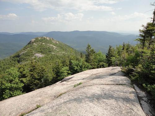
The Welch-Dickey loop trail hike is the ideal Spring warm-up hike for two big reasons: It is among the first of the trails in NH's White Mountains to be clear of snow and ice in the spring; and at barely five miles in length, it offers pretty much everything that the White Mountains have to offer, but in small doses. No wonder the AMC White Mountains Guide describes it as a trail that offers excellent views for a modest effort. However, do not be deceived by this comment, as there are some steep sections which will give you a workout, even if they are indeed short.
This being April, be prepared for any type of weather, so bring layers to put on and take off accordingly. Also bring one or two liters of water, as there is no potable water on the trail. We plan to hike counterclockwise, which will take us to the ledges below the summit of Mt. Welch, and then to the summit itself, where we will stop for lunch. So bring a lunch and/or snacks to share. We should be done hiking by 3:00 p.m or so, and if there is a clamor for more camaraderie, we can then decide to go for an early dinner and/or beer at one of the local watering holes.
Directions
We will meet at the trailhead parking lot. To get there from I-93, get off at exit 28 (Campton/Waterville Valley) and go east on Rt. 49 (also known as the Mad River Road). As you make the turn, and if it is a clear day, you should see the open ledges of Welch-Dickey looming ahead of you. Go east on Rt 49 towards those mountains. At approximately 4.5 miles after you pass the Campton Dam (there is a traffic light there, as this is the junction with Rt. 175), turn left onto Upper Mad River Road. At 0.7 miles turn right onto Orris Rd., where you should see a sign directing you to the Welch-Dickey trailhead. At 0.6 miles, Orris Road makes a sharp turn to the left, and the trailhead parking will be on your right. We will be driving a red Rav4, with NH plates.
About this event
The Welch-Dickey loop trail hike is the ideal Spring warm-up hike for two big reasons: It is among the first of the trails in NH's White Mountains to be clear of snow and ice in the spring; and at barely five miles in length, it offers pretty much everything that the White Mountains have to offer, but in small doses. No wonder the AMC White Mountains Guide describes it as a trail that offers excellent views for a modest effort. However, do not be deceived by this comment, as there are some steep sections which will give you a workout, even if they are indeed short.
This being April, be prepared for any type of weather, so bring layers to put on and take off accordingly. Also bring one or two liters of water, as there is no potable water on the trail. We plan to hike counterclockwise, which will take us to the ledges below the summit of Mt. Welch, and then to the summit itself, where we will stop for lunch. So bring a lunch and/or snacks to share. We should be done hiking by 3:00 p.m or so, and if there is a clamor for more camaraderie, we can then decide to go for an early dinner and/or beer at one of the local watering holes.
Directions to the trailhead
Get directionsWe will meet at the trailhead parking lot. To get there from I-93, get off at exit 28 (Campton/Waterville Valley) and go east on Rt. 49 (also known as the Mad River Road). As you make the turn, and if it is a clear day, you should see the open ledges of Welch-Dickey looming ahead of you. Go east on Rt 49 towards those mountains. At approximately 4.5 miles after you pass the Campton Dam (there is a traffic light there, as this is the junction with Rt. 175), turn left onto Upper Mad River Road. At 0.7 miles turn right onto Orris Rd., where you should see a sign directing you to the Welch-Dickey trailhead. At 0.6 miles, Orris Road makes a sharp turn to the left, and the trailhead parking will be on your right. We will be driving a red Rav4, with NH plates.
Who's going (13)
 SUSTAINING
  SUSTAINING
  GUEST MEMBER
  SUSTAINING
  GUEST MEMBER
  GUEST MEMBER
  GUEST MEMBER
  SUSTAINING
  GUEST MEMBER
 Waiting list (3)


Questions about this event?
Reach out to the host, JPHiker, for route details, carpooling, or what to bring.
Email the hostYou can also ask in the event discussion below.
Event discussion
No comments yet.
Log in to join the conversation.