
Mishe Mokwa Trail to Sandstone Peak
One of the Most Beautiful Hikes in the Santa Monica Mountains
Mishe Mokwa Trail to Sandstone Peak
One of the Most Beautiful Hikes in the Santa Monica Mountains
Details
Length: 7 miles – 4 hours
Difficulty: Moderate to strenuous
Elevation gain: 1300 feet
Configuration: Loop
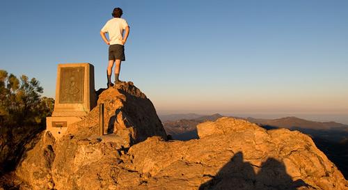
Description: This is one of the most beautiful hikes in the Santa Monica Mountains and considered one of the best hikes in Southern California. Highlights include the spectacular Echo Cliffs where rock climbers ascend shear cliffs, a house sized boulder delicately balanced on a small rock beneath, a giant split rock, stunning giant sandstone formations, and breathtaking views from the top of Sandstone Peak and Inspiration point. Sandstone Peak is the tallest in the Santa Monica Mountains at 3111 feet.
Directions
Address: 14041 Yerba Buena RD, Malibu, CA
From 101 Fwy/Westlake BL to trailhead is about 35 minutes. Please plan your commute accordingly
- Follow US-101 N to CA-23 South/S Westlake Blvd in Thousand Oaks. (Exit 40 from US-101 N). Use the left 2 lanes to turn left onto Westlake Blvd (CA-23 S)
- Continue to follow CA-23 S for 7.2 miles
- Slight right turn onto Mulholland Hwy. Go for .4 miles
- Turn right at Little Sycamore Canyon Rd 1.9 mi. Do not turn left onto Decker Rd!!
- Little Sycamore Canyon Rd becomes Yerba Buena Rd, continue for 2.7 mi.
If you have a navigation system, here are the coordinates:
+34° 6' 41.82", -118° 55' 35.34" or map to 14041 Yerba Buena RD, Malibu, CA
As you are traveling on Yerba Buena Rd, you will pass a parking area that has a parking lot on each side of the road. This is the trailhead to the Mishe Mokwa trail. The next parking lot is on the right and is the Sandstone Peak/Backbone Trail parking lot. This is the parking lot where we will start our hike. If you reach the Circle X Ranger station you have gone to far.
From PCH North, Hwy 1: Northbound on Hwy 1, turn right on Yerba Buena and go about 6 miles. Parking lot is on the left.
What to Bring: Good hiking boots/shoes. A hiking/trekking pole may be useful for the occasional step ascent/descent on the trail, but not necessary. Pack a lunch, snacks and bring plenty of water. Bring a hat/cap and sunscreen. Rain cancels but threat of rain does not.
About this event
Length: 7 miles – 4 hours
Difficulty: Moderate to strenuous
Elevation gain: 1300 feet
Configuration: Loop
Description: This is one of the most beautiful hikes in the Santa Monica Mountains and considered one of the best hikes in Southern California. Highlights include the spectacular Echo Cliffs where rock climbers ascend shear cliffs, a house sized boulder delicately balanced on a small rock beneath, a giant split rock, stunning giant sandstone formations, and breathtaking views from the top of Sandstone Peak and Inspiration point. Sandstone Peak is the tallest in the Santa Monica Mountains at 3111 feet.
Directions to the trailhead
Get directionsAddress: 14041 Yerba Buena RD, Malibu, CA
From 101 Fwy/Westlake BL to trailhead is about 35 minutes. Please plan your commute accordingly
- Follow US-101 N to CA-23 South/S Westlake Blvd in Thousand Oaks. (Exit 40 from US-101 N). Use the left 2 lanes to turn left onto Westlake Blvd (CA-23 S)
- Continue to follow CA-23 S for 7.2 miles
- Slight right turn onto Mulholland Hwy. Go for .4 miles
- Turn right at Little Sycamore Canyon Rd 1.9 mi. Do not turn left onto Decker Rd!!
- Little Sycamore Canyon Rd becomes Yerba Buena Rd, continue for 2.7 mi.
If you have a navigation system, here are the coordinates:
+34° 6' 41.82", -118° 55' 35.34" or map to 14041 Yerba Buena RD, Malibu, CA
As you are traveling on Yerba Buena Rd, you will pass a parking area that has a parking lot on each side of the road. This is the trailhead to the Mishe Mokwa trail. The next parking lot is on the right and is the Sandstone Peak/Backbone Trail parking lot. This is the parking lot where we will start our hike. If you reach the Circle X Ranger station you have gone to far.
From PCH North, Hwy 1: Northbound on Hwy 1, turn right on Yerba Buena and go about 6 miles. Parking lot is on the left.
What to Bring: Good hiking boots/shoes. A hiking/trekking pole may be useful for the occasional step ascent/descent on the trail, but not necessary. Pack a lunch, snacks and bring plenty of water. Bring a hat/cap and sunscreen. Rain cancels but threat of rain does not.
Who's going (0)
No one is on the roster for this event.
Questions about this event?
Questions for the host, Menard, about route details, carpooling, or what to bring? Ask in the event discussion below.
Event discussion
No comments yet.
Log in to join the conversation.