
The Treasure of the Sierra Madre: Part 3
A grand loop through the east end of the rugged Sierra Madre Mountains.
The Treasure of the Sierra Madre: Part 3
A grand loop through the east end of the rugged Sierra Madre Mountains.
Details
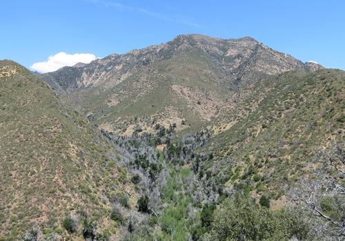
Unlike Humphrey Bogart, we’ll have no fear of bandits and corrupt federales and we’ll even stay on this side of the border as we seek out the treasures of the Sierra Madre Mountains, the rugged backbone of the remote San Rafael and Dick Smith Wilderness areas, deep in the Santa Barbara backcountry. If you were with us on our trips there in 2011 and 2012, you know that the San Rafael in the spring is a fantasyland of rushing rivers and green meadows full of wildflowers. This long weekend backpack will take us on a loop farther to the east, into the condor-haunted high country around Madulce Potrero.
Before Highway 33 was built in the early 1930’s, Santa Barbara Canyon was the route travelers took between the Central Valley and Santa Barbara. Now it probably sees more footprints by bears than people most days. Our route takes us through the canyon, up and over aptly-named Heart Break Hill, around Madulce Peak and Alamar Saddle, and into the rarely-visited headwaters of the Sisquoc River.
This will be a strenuous backpack, covering nearly 25 miles in two days at a purposeful pace over difficult trail and very rugged terrain, so this trip is suitable only for experienced backpackers in very good condition. We’ll cheerfully face the possibility of bushwhacking, ticks, rattlesnakes fresh from hibernation, and occasional poison oak. Because of the strenuous nature of this trip, the leader reserves the right to qualify participants. This is a consciously low-impact outing, so carpool participation is encouraged and participants are urged to contribute to their vehicle’s shared mileage and gas costs.
This trip is strictly dependent upon a favorable weather forecast. A National Weather Service forecast of rain within 72 hours of our start will cancel or re-route this trip at the sole discretion of the leader, as will fewer than three confirmed signups as of 8:00pm, Thursday, March 10. This trip will be by individual commissary, and we’re not planning any shared meals, so please plan to provide your own supply of food.
Directions
We’ll meet up to consolidate our carpool at the Camarillo Park-and-Ride (Pleasant Valley Road x US101) at 6:30am (SHARP!) on the morning of Saturday, March 12 in preparation for our long (1.5-hour) drive to the trailhead. L.A.-based hikers should plan on leaving L.A. no later than 5:30am.
About this event
Unlike Humphrey Bogart, we’ll have no fear of bandits and corrupt federales and we’ll even stay on this side of the border as we seek out the treasures of the Sierra Madre Mountains, the rugged backbone of the remote San Rafael and Dick Smith Wilderness areas, deep in the Santa Barbara backcountry. If you were with us on our trips there in 2011 and 2012, you know that the San Rafael in the spring is a fantasyland of rushing rivers and green meadows full of wildflowers. This long weekend backpack will take us on a loop farther to the east, into the condor-haunted high country around Madulce Potrero.
Before Highway 33 was built in the early 1930’s, Santa Barbara Canyon was the route travelers took between the Central Valley and Santa Barbara. Now it probably sees more footprints by bears than people most days. Our route takes us through the canyon, up and over aptly-named Heart Break Hill, around Madulce Peak and Alamar Saddle, and into the rarely-visited headwaters of the Sisquoc River.
This will be a strenuous backpack, covering nearly 25 miles in two days at a purposeful pace over difficult trail and very rugged terrain, so this trip is suitable only for experienced backpackers in very good condition. We’ll cheerfully face the possibility of bushwhacking, ticks, rattlesnakes fresh from hibernation, and occasional poison oak. Because of the strenuous nature of this trip, the leader reserves the right to qualify participants. This is a consciously low-impact outing, so carpool participation is encouraged and participants are urged to contribute to their vehicle’s shared mileage and gas costs.
This trip is strictly dependent upon a favorable weather forecast. A National Weather Service forecast of rain within 72 hours of our start will cancel or re-route this trip at the sole discretion of the leader, as will fewer than three confirmed signups as of 8:00pm, Thursday, March 10. This trip will be by individual commissary, and we’re not planning any shared meals, so please plan to provide your own supply of food.
Directions to the trailhead
Get directionsWe’ll meet up to consolidate our carpool at the Camarillo Park-and-Ride (Pleasant Valley Road x US101) at 6:30am (SHARP!) on the morning of Saturday, March 12 in preparation for our long (1.5-hour) drive to the trailhead. L.A.-based hikers should plan on leaving L.A. no later than 5:30am.
Who's going (5)
Questions about this event?
Reach out to the host, CJDGO, for route details, carpooling, or what to bring.
Email the hostYou can also ask in the event discussion below.
Event discussion
Log in to join the conversation.