
Mt. Waterman Day Hike – San Gabriel Mtns
Gateway to San Gabriel Wilderness - Sweeping Vistas, Boulder Formations, Large stands of Cedar
Mt. Waterman Day Hike – San Gabriel Mtns
Gateway to San Gabriel Wilderness - Sweeping Vistas, Boulder Formations, Large stands of Cedar
Details
November 15, 2015 –
7 miles round trip
Carpool parking area 9:30 AM or trailhead 10:30 AM
Hike Leader: Russell
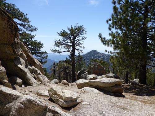
It’s a gentle but steady climb from the trailhead to the summit of Mt. Waterman. Hikers will immediately understand why the Mt. Waterman trail is one of the most popular hikes in the San Gabriel Mountain… “The Gabbies”. The trail winds through pine forest, and offers intermittent views towards the High Desert and into the depths of Devils Canyon. Though the broad summit may not be as awe-inspiring as more jagged peaks, from atop the rocky outcropping at its 8038’ summit, hikers are rewarded with sweeping views of the Western spine of The Gabbies.
Bring: November weather can be unpredictable in the upper elevations of San Gabriel Mountains so warm layered clothing is appropriate; shed what you don’t need at the trailhead. Pack water, energy bars, and lunch (which we’ll eat at the summit). Rain or threat of rain cancels.
How to get there & carpooling: You may meet us at the trailhead (directions below) or at the La Canada carpooling location where you may offer hikers ride or find a driver to ride with. We will meet at the carpooling location at 9:30 AM or the trailhead at 10:30 AM.
Russell is leading this hike for both the Gay Outdoors and the Great Outdoors members. Note: women may be participating.
Directions
Directions: The carpooling location is just north of the 210 freeway at the Angeles Crest Hwy exit (The 2). Look for cars parked along the road on the east side of Angles Crest & Milmada in La Canada. Be mindful that other hikes & groups depart from this location; may sure you find the Great Outdoors/ Mt. Waterman hike.
If you prefer to drive yourself; it’s 33 miles from the carpool location up the Angeles Crest Highway to the trailhead. There is a large, but unmarked parking area off the northeast side of the highway (near the Buckhorn campground). You must display an Adventure Pass on your vehicle (and may purchase a day pass at the Clear Creek Ranger Station you’ll pass along the way). Wait for carpoolers to join you.
Driving Notes: You must access the trailhead from the west (via the Angeles Crest Highway from La Canada). Access to the trailhead from Wrightwood is temporarily closed due to a landslide & the Angeles Crest Highway is shut down to through traffic. For questions about this hike you may contact Russell.
About this event
November 15, 2015 –
7 miles round trip
Carpool parking area 9:30 AM or trailhead 10:30 AM
Hike Leader: Russell
It’s a gentle but steady climb from the trailhead to the summit of Mt. Waterman. Hikers will immediately understand why the Mt. Waterman trail is one of the most popular hikes in the San Gabriel Mountain… “The Gabbies”. The trail winds through pine forest, and offers intermittent views towards the High Desert and into the depths of Devils Canyon. Though the broad summit may not be as awe-inspiring as more jagged peaks, from atop the rocky outcropping at its 8038’ summit, hikers are rewarded with sweeping views of the Western spine of The Gabbies.
Bring: November weather can be unpredictable in the upper elevations of San Gabriel Mountains so warm layered clothing is appropriate; shed what you don’t need at the trailhead. Pack water, energy bars, and lunch (which we’ll eat at the summit). Rain or threat of rain cancels.
How to get there & carpooling: You may meet us at the trailhead (directions below) or at the La Canada carpooling location where you may offer hikers ride or find a driver to ride with. We will meet at the carpooling location at 9:30 AM or the trailhead at 10:30 AM.
Russell is leading this hike for both the Gay Outdoors and the Great Outdoors members. Note: women may be participating.
Directions to the trailhead
Get directionsDirections: The carpooling location is just north of the 210 freeway at the Angeles Crest Hwy exit (The 2). Look for cars parked along the road on the east side of Angles Crest & Milmada in La Canada. Be mindful that other hikes & groups depart from this location; may sure you find the Great Outdoors/ Mt. Waterman hike.
If you prefer to drive yourself; it’s 33 miles from the carpool location up the Angeles Crest Highway to the trailhead. There is a large, but unmarked parking area off the northeast side of the highway (near the Buckhorn campground). You must display an Adventure Pass on your vehicle (and may purchase a day pass at the Clear Creek Ranger Station you’ll pass along the way). Wait for carpoolers to join you.
Driving Notes: You must access the trailhead from the west (via the Angeles Crest Highway from La Canada). Access to the trailhead from Wrightwood is temporarily closed due to a landslide & the Angeles Crest Highway is shut down to through traffic. For questions about this hike you may contact Russell.
Who's going (0)
No one is on the roster for this event.
Questions about this event?
Questions for the host, Menard, about route details, carpooling, or what to bring? Ask in the event discussion below.
Event discussion
Log in to join the conversation.