
Montalban Ridge Traverse
A Traverse with Plenty of Views Along the Montalban Ridge.
Montalban Ridge Traverse
A Traverse with Plenty of Views Along the Montalban Ridge.
Details
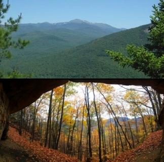
Join me for this 9.2 mile hike along the ridge between Mt. Stanton (1716') and Mt. Langdon (2390'). Along the way we will also be traversing across Mt. Pickering (1930) and "the Crippies". This ridge is known as the Montalban Ridge. There are ample views along this way, which include the Attitash Ski Area, Crawford Notch, Iron Mountain and the Presidential peaks. On the return we'll descend to Bartlett via the Mt. Langdon Trail and take the short spur trail to Cave Mountain en route.
Total miles and elevation gain: 9.2 miles and approximately 3250 feet in cumulative elevation gain.
Rain or harsh weather will postpone to another date or cancel, as appropriate.
What to Bring: Typical late fall hiking gear should be appropriate: convertible hiking pants, good sturdy hiking boots with thick socks, gloves, knit cap, and a windbreaker/raingear/fleece layer. Your boots should have good traction. Also bring along lunch, snacks and plenty of water (at least 2-L). Optionally, pack bug repellent and sunscreen and anything else that you may require for a day hike.
Carpooling: Contact the leader or other participants to organize a ride share.
Afterwards: If there is sufficient interest, we will have drinks and/or dinner in the area.
Directions
At the light in Barlett (at the junction of Rt 302 and Bear Notch Road) turn north onto River Street Take this to the end where it "T's" with Cobb Farm Road. There is parking here near this junction. Look for a grey Hyundai Elantra.
NOTE: Bear Notch Road may or may not still be open, so plan accordingly. The status can be found at the USDA Forest Service Site.
GPS Coordinates for Trailhead: 44.084132, -71.286292 (68 Cobb Farm Rd; Bartlett, NH 03812)
We'll be meeting at the trailhead (described above) in Bartlett and carpooling over to the trailhead on Covered Bridge Lane in Glen for this traverse. The address ONLY IF YOU'RE LATE: 44.095358, -71.212212 (45 Covered Bridge Lane; Glen, NH 03838).
About this event
Join me for this 9.2 mile hike along the ridge between Mt. Stanton (1716') and Mt. Langdon (2390'). Along the way we will also be traversing across Mt. Pickering (1930) and "the Crippies". This ridge is known as the Montalban Ridge. There are ample views along this way, which include the Attitash Ski Area, Crawford Notch, Iron Mountain and the Presidential peaks. On the return we'll descend to Bartlett via the Mt. Langdon Trail and take the short spur trail to Cave Mountain en route.
Total miles and elevation gain: 9.2 miles and approximately 3250 feet in cumulative elevation gain.
Rain or harsh weather will postpone to another date or cancel, as appropriate.
What to Bring: Typical late fall hiking gear should be appropriate: convertible hiking pants, good sturdy hiking boots with thick socks, gloves, knit cap, and a windbreaker/raingear/fleece layer. Your boots should have good traction. Also bring along lunch, snacks and plenty of water (at least 2-L). Optionally, pack bug repellent and sunscreen and anything else that you may require for a day hike.
Carpooling: Contact the leader or other participants to organize a ride share.
Afterwards: If there is sufficient interest, we will have drinks and/or dinner in the area.
Directions to the trailhead
Get directionsAt the light in Barlett (at the junction of Rt 302 and Bear Notch Road) turn north onto River Street Take this to the end where it "T's" with Cobb Farm Road. There is parking here near this junction. Look for a grey Hyundai Elantra.
NOTE: Bear Notch Road may or may not still be open, so plan accordingly. The status can be found at the USDA Forest Service Site.
GPS Coordinates for Trailhead: 44.084132, -71.286292 (68 Cobb Farm Rd; Bartlett, NH 03812)
We'll be meeting at the trailhead (described above) in Bartlett and carpooling over to the trailhead on Covered Bridge Lane in Glen for this traverse. The address ONLY IF YOU'RE LATE: 44.095358, -71.212212 (45 Covered Bridge Lane; Glen, NH 03838).
Who's going (2)
 GUEST MEMBER
 Questions about this event?
Reach out to the host, shep5, for route details, carpooling, or what to bring.
Email the hostYou can also ask in the event discussion below.
Event discussion
No comments yet.
Log in to join the conversation.