
Wildcats Mountains A & D Hike
Bag two 4,000 footers and with spectacular views of the glacial cirques of Mt. Washington!
Wildcats Mountains A & D Hike
Bag two 4,000 footers and with spectacular views of the glacial cirques of Mt. Washington!
Details
Bag two 4,000 footers and with spectacular views of the glacial cirques of Mt. Washington!
Distance: 9.3 Miles
Elevation Gain: 3250 feet
Time Duration: Approximately 8 Hours
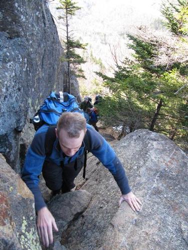
We're going to do an 9.3 mile loop via the Wildcat Ridge Trail that will carry us across Wildcats A, B, C, D and E. We will start hiking on the Lost Pond Trail however we will meet at the Nineteen Mile Brook Trail first to drop off a few vehicles. Please note that the start of the Wildcat Ridge Trail begins with an exceptionally steep, rocky and rugged climb featuring rock steps, a small ladder and challenging scramble through a chimney that provides anxiety for some hikers.
Wildcat Mountain is a long ridge consisting of five subpeaks named, from north to south:
Wildcat A (4422 feet)
Wildcat B (4330 feet)
Wildcat C (4298 feet)
Wildcat D (4062 feet) and
Wildcat E (4046 feet)
For peak baggers, the two that count on the New Hampshire 4,000 footer list are Wildcat A and Wildcat D.
The mountain provides some interesting and challenging hiking, but what it has to offer more than anything else is the spectacular view of the Presidential Range. Just a few miles to the west lies Mt. Washington, and the view from Wildcat is straight into Tuckerman Ravine and Huntington Ravine. Several other lesser New Hampshire and Maine ranges are also visible from the many lookouts along the Wildcat Ridge Trail, which is also the Appalachian Trail. Sebago Lake in Maine and the Atlantic Ocean are visible on the clearest days. The mountain is a good day hike.
The primary trail across the Wildcats is the Wildcat Ridge Trail, which, for the most part, is also the Appalachian Trail. We will start from Pinkham Notch Visitor Center and use the Lost Pond Trail to hook up with the Wildcat Ridge Trail. The distance to Wildcat D is approximately 2.9 miles, to A is 5.1 miles, with a total elevation gain of 3250 feet. The distance to the Nineteen-Mile Brook Trail is 5.8 miles. Between the summit of Wildcat A and the Carter Notch, the trail drops about 900 feet in .7 miles over some rugged terrain, which can be tricky.
It is then 3.6 miles of hiking on the Nineteen Mile Brook Trail to return back to our vehicles on Route 16.
You will need well fitted, broken-in hiking boots and a day pack large enough to carry everything. Since November is into ice season it will be a MUST to bring traction such as MicroSpikes. There will be plenty of ice and traces of snow up high. If you haven't used winter gear before, you should probably test it out and practice before this hike! Bring extra layers for summit conditions which will be windy and COLD. Don't forget tor bring your hat and gloves.
Bring 2 liters of water minimum, lunch and snacks.
After The Hike: Everyone is welcome to join us for an early dinner at the Red Fox Grill in Jackson, NH. You may want to bring a change of clothing to be more comfortable.
Lodging Option: We have 8 bunks available at our house near Waterville Valley, NH for Friday and/or Saturday night at $20 per night. Coffee/bagels each morning and linen/blankets/towels are provided. We have limited space in the fridge to store your beverages/food so it's best to bring a small cooler. Space is limited so email us ASAP to reserve a bunk!
Directions
Follow NH Route 16 north through Pinkham Notch. The trailhead parking area is on the right [east] side of the highway exactly 1 mile north of the entrance to the Mt. Washington auto road. We'll be driving a blue Toyota FJ Cruiser.
About this event
Bag two 4,000 footers and with spectacular views of the glacial cirques of Mt. Washington!
Distance: 9.3 Miles
Elevation Gain: 3250 feet
Time Duration: Approximately 8 Hours
We're going to do an 9.3 mile loop via the Wildcat Ridge Trail that will carry us across Wildcats A, B, C, D and E. We will start hiking on the Lost Pond Trail however we will meet at the Nineteen Mile Brook Trail first to drop off a few vehicles. Please note that the start of the Wildcat Ridge Trail begins with an exceptionally steep, rocky and rugged climb featuring rock steps, a small ladder and challenging scramble through a chimney that provides anxiety for some hikers.
Wildcat Mountain is a long ridge consisting of five subpeaks named, from north to south:
Wildcat A (4422 feet)
Wildcat B (4330 feet)
Wildcat C (4298 feet)
Wildcat D (4062 feet) and
Wildcat E (4046 feet)
For peak baggers, the two that count on the New Hampshire 4,000 footer list are Wildcat A and Wildcat D.
The mountain provides some interesting and challenging hiking, but what it has to offer more than anything else is the spectacular view of the Presidential Range. Just a few miles to the west lies Mt. Washington, and the view from Wildcat is straight into Tuckerman Ravine and Huntington Ravine. Several other lesser New Hampshire and Maine ranges are also visible from the many lookouts along the Wildcat Ridge Trail, which is also the Appalachian Trail. Sebago Lake in Maine and the Atlantic Ocean are visible on the clearest days. The mountain is a good day hike.
The primary trail across the Wildcats is the Wildcat Ridge Trail, which, for the most part, is also the Appalachian Trail. We will start from Pinkham Notch Visitor Center and use the Lost Pond Trail to hook up with the Wildcat Ridge Trail. The distance to Wildcat D is approximately 2.9 miles, to A is 5.1 miles, with a total elevation gain of 3250 feet. The distance to the Nineteen-Mile Brook Trail is 5.8 miles. Between the summit of Wildcat A and the Carter Notch, the trail drops about 900 feet in .7 miles over some rugged terrain, which can be tricky.
It is then 3.6 miles of hiking on the Nineteen Mile Brook Trail to return back to our vehicles on Route 16.
You will need well fitted, broken-in hiking boots and a day pack large enough to carry everything. Since November is into ice season it will be a MUST to bring traction such as MicroSpikes. There will be plenty of ice and traces of snow up high. If you haven't used winter gear before, you should probably test it out and practice before this hike! Bring extra layers for summit conditions which will be windy and COLD. Don't forget tor bring your hat and gloves.
Bring 2 liters of water minimum, lunch and snacks.
After The Hike: Everyone is welcome to join us for an early dinner at the Red Fox Grill in Jackson, NH. You may want to bring a change of clothing to be more comfortable.
Lodging Option: We have 8 bunks available at our house near Waterville Valley, NH for Friday and/or Saturday night at $20 per night. Coffee/bagels each morning and linen/blankets/towels are provided. We have limited space in the fridge to store your beverages/food so it's best to bring a small cooler. Space is limited so email us ASAP to reserve a bunk!
Directions to the trailhead
Get directionsFollow NH Route 16 north through Pinkham Notch. The trailhead parking area is on the right [east] side of the highway exactly 1 mile north of the entrance to the Mt. Washington auto road. We'll be driving a blue Toyota FJ Cruiser.
Who's going (7)
 SUSTAINING
  GUEST MEMBER
  GUEST MEMBER
  SUSTAINING
 Questions about this event?
Reach out to the host, Gandalf, for route details, carpooling, or what to bring.
Email the hostYou can also ask in the event discussion below.
Event discussion
No comments yet.
Log in to join the conversation.