
Moat Mountains Traverse
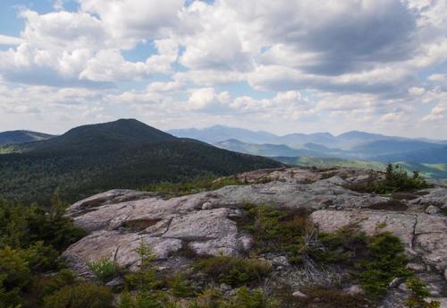
The Moat Mountain Trail traverses the main ridge of Moat Mountain, with magnificent views from South, Middle and North Moat mtns near peak foliage!
Moat Mountains Traverse
The Moat Mountain Trail traverses the main ridge of Moat Mountain, with magnificent views from South, Middle and North Moat mtns near peak foliage!
Details
The Moat Mountain Trail traverses the main ridge of Moat Mountain, with magnificent views from South, Middle and North Moat mountains at peak foliage! Both North (3196') and South (2770') Moat are on the “52 With A View” list. After the hike we’ll have brews and dinner at...surprise surprise...the nearby Moat Mountain Brewery.
Moat Mountain, an elongated, craggy ridge, establishes the horizon west of Conway. The unnatural tree line at 2700 feet resulted from a fire in September 1854, when flames consumed the trees on the once forested landmark above the Saco River. We should be starting to see the fall foliage colors appearing. Every time we return to the bare cone of volcanic rock on North Mountain, we are awed at the jumble of mountain that rolls in a vast sweep from Carter Dome to Chocorua! And South Moat Mountain’s bare cone is almost as good as North Moat!
We will meet at the southern end of the Moat Mountain Trail at 9:00am, leave a few cars, and drive to the northern end to begin our hike. On this hike we will go 9.7 miles with an elevation gain of 3362'. We are aiming for a finish of 5pm. Bring plenty of water, lunch, snacks and appropriate clothing for the weather conditions.
Please read the entire event description before you RSVP. It is important, not only for your safety, but that of the entire group.
Mountain weather is subject to rapid changes and extreme conditions. Dangerous weather conditions will cancel - we will post an and/or send an email to all confirmed participants a day or two ahead of time so make sure your email address on the site is correct. We will assess travel and weather conditions during the hike and make changes to our planned trip as necessary.
If anyone would like to carpool, leave a comment in the comment section.
Lodging Option: Bunk beds are available at our house near Waterville Valley, NH for Friday and/or Saturday night at $20 per night. Coffee/bagels each morning and linen/blankets/towels are provided. We have limited space in the fridge to store your beverages/food so it's best to bring a small cooler. Space is limited so email ASAP to reserve a bunk!
Directions
Our meeting spot is at our southern finish before carpooling to the start further North. The southern terminus is located on Dugway Road. At the lights in Conway village, turn north [directly opposite NH 153] onto Washington St., which becomes West Side Road. Go left at a fork, then at 0.9 mile, turn left on Passaconaway Road which becomes Dugway Road. We'll meet at the new trailhead parking area on the right, 4.1 miles from Conway. [Dugway Road continues and joins the Kancamagus Highway near Blackberry Crossing Campground so it's an option if travelling on the Kanc from Lincoln, NH.]
About this event
The Moat Mountain Trail traverses the main ridge of Moat Mountain, with magnificent views from South, Middle and North Moat mountains at peak foliage! Both North (3196') and South (2770') Moat are on the “52 With A View” list. After the hike we’ll have brews and dinner at...surprise surprise...the nearby Moat Mountain Brewery.
Moat Mountain, an elongated, craggy ridge, establishes the horizon west of Conway. The unnatural tree line at 2700 feet resulted from a fire in September 1854, when flames consumed the trees on the once forested landmark above the Saco River. We should be starting to see the fall foliage colors appearing. Every time we return to the bare cone of volcanic rock on North Mountain, we are awed at the jumble of mountain that rolls in a vast sweep from Carter Dome to Chocorua! And South Moat Mountain’s bare cone is almost as good as North Moat!
We will meet at the southern end of the Moat Mountain Trail at 9:00am, leave a few cars, and drive to the northern end to begin our hike. On this hike we will go 9.7 miles with an elevation gain of 3362'. We are aiming for a finish of 5pm. Bring plenty of water, lunch, snacks and appropriate clothing for the weather conditions.
Please read the entire event description before you RSVP. It is important, not only for your safety, but that of the entire group.
Mountain weather is subject to rapid changes and extreme conditions. Dangerous weather conditions will cancel - we will post an and/or send an email to all confirmed participants a day or two ahead of time so make sure your email address on the site is correct. We will assess travel and weather conditions during the hike and make changes to our planned trip as necessary.
If anyone would like to carpool, leave a comment in the comment section.
Lodging Option: Bunk beds are available at our house near Waterville Valley, NH for Friday and/or Saturday night at $20 per night. Coffee/bagels each morning and linen/blankets/towels are provided. We have limited space in the fridge to store your beverages/food so it's best to bring a small cooler. Space is limited so email ASAP to reserve a bunk!
Directions to the trailhead
Get directionsOur meeting spot is at our southern finish before carpooling to the start further North. The southern terminus is located on Dugway Road. At the lights in Conway village, turn north [directly opposite NH 153] onto Washington St., which becomes West Side Road. Go left at a fork, then at 0.9 mile, turn left on Passaconaway Road which becomes Dugway Road. We'll meet at the new trailhead parking area on the right, 4.1 miles from Conway. [Dugway Road continues and joins the Kancamagus Highway near Blackberry Crossing Campground so it's an option if travelling on the Kanc from Lincoln, NH.]
Who's going (9)
 SUSTAINING
  SUSTAINING
  GUEST MEMBER
  SUSTAINING
  GUEST MEMBER
  GUEST MEMBER
  GUEST MEMBER
 Questions about this event?
Reach out to the host, Gandalf, for route details, carpooling, or what to bring.
Email the hostYou can also ask in the event discussion below.
Event discussion
I was wondering if I could do car pool with you guys in Campton post office or somewhere near there. Please let me know if it would be
possible. I look forward this trip.
Kevin
Thank you so much!
Kevin
Log in to join the conversation.