
Mt. Washington
Hike up the Northeast’s tallest peak on the Fourth of July!
Mt. Washington
Hike up the Northeast’s tallest peak on the Fourth of July!
Details
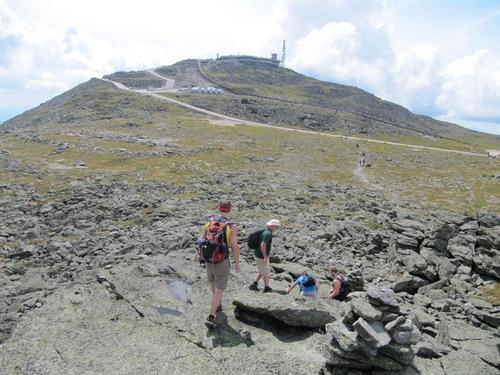
At 6,288 ft. Mt. Washington is the tallest of the NH 4,000 footers and the highest in all of New England and the Northeast. Though the summit is puny compared to other great mountain ranges of the world, Mt. Washington is renowned worldwide for its fierce weather and frequent fatalities. Being the tallest of the peaks, it’s no surprise that the mountain is among the most visited summits in New England. We will ascend up the Jewell Trail from the base of the Cog Railroad with lunch in the summit cafeteria.
This is probably the ‘easiest’ approach to Mt. Washington; grades are mostly moderate with generally good footing, though the upper section of Jewell Trail above treeline is rough and rocky. We break treeline after 2 miles with wide views of the Southern Presidentials, Bretton Woods valley, and ranges to the West. It is fully exposed to weather in the next 2 miles as it ascends the westerly ridge of Mt. Clay, then follows the main ridge to Mt. Washington, with some spectacular views into the Great Gulf!
This is up and back hike on the same trail. Because the hike involves extensive hiking above treeline, attention to safety and the mountain’s notoriously fickle weather is of paramount importance. Proper gear is a must!!!
In addition to safety precautions, you should note that this is arduous climb involving 4,000 elevation gain. It will be 8 miles roundtrip. Plan on a finish of 5pm.
After The Hike: Everyone is welcome back at our house in Waterville Valley for a 4th of July BBQ! It’s BYOB and it costs $5 per person. It we get back early enough we take a dip in the Mad River. After the BBQ, depending on the group’s wishes, we can have a campfire or take a short drive to Waterville Valley to watch their awesome fireworks!
Lodging Option: Bunk beds are available at our house near Waterville Valley, NH for Friday and/or Saturday night at $20 per night. Coffee/bagels each morning and linen/blankets/towels are provided. We have limited space in the fridge to store your beverages/food so it's best to bring a small cooler. Space is limited so email ASAP to reserve a bunk!
Directions
We will be meeting at the front of the Cog Railway Base Lodge building at 8AM. You should park at the Base Lodge parking area that charges a nominal fee. Don't park in the WMNF designated parking area a mile away unless you plan to get there early to hike to Base Lodge to meet us in time.
Leave US 302 at Fabyan and drive down on the Base Road to very end where someone will collect a nominal parking fee [perhaps $5] and direct you where to park.
About this event
At 6,288 ft. Mt. Washington is the tallest of the NH 4,000 footers and the highest in all of New England and the Northeast. Though the summit is puny compared to other great mountain ranges of the world, Mt. Washington is renowned worldwide for its fierce weather and frequent fatalities. Being the tallest of the peaks, it’s no surprise that the mountain is among the most visited summits in New England. We will ascend up the Jewell Trail from the base of the Cog Railroad with lunch in the summit cafeteria.
This is probably the ‘easiest’ approach to Mt. Washington; grades are mostly moderate with generally good footing, though the upper section of Jewell Trail above treeline is rough and rocky. We break treeline after 2 miles with wide views of the Southern Presidentials, Bretton Woods valley, and ranges to the West. It is fully exposed to weather in the next 2 miles as it ascends the westerly ridge of Mt. Clay, then follows the main ridge to Mt. Washington, with some spectacular views into the Great Gulf!
This is up and back hike on the same trail. Because the hike involves extensive hiking above treeline, attention to safety and the mountain’s notoriously fickle weather is of paramount importance. Proper gear is a must!!!
In addition to safety precautions, you should note that this is arduous climb involving 4,000 elevation gain. It will be 8 miles roundtrip. Plan on a finish of 5pm.
After The Hike: Everyone is welcome back at our house in Waterville Valley for a 4th of July BBQ! It’s BYOB and it costs $5 per person. It we get back early enough we take a dip in the Mad River. After the BBQ, depending on the group’s wishes, we can have a campfire or take a short drive to Waterville Valley to watch their awesome fireworks!
Lodging Option: Bunk beds are available at our house near Waterville Valley, NH for Friday and/or Saturday night at $20 per night. Coffee/bagels each morning and linen/blankets/towels are provided. We have limited space in the fridge to store your beverages/food so it's best to bring a small cooler. Space is limited so email ASAP to reserve a bunk!
Directions to the trailhead
Get directionsWe will be meeting at the front of the Cog Railway Base Lodge building at 8AM. You should park at the Base Lodge parking area that charges a nominal fee. Don't park in the WMNF designated parking area a mile away unless you plan to get there early to hike to Base Lodge to meet us in time.
Leave US 302 at Fabyan and drive down on the Base Road to very end where someone will collect a nominal parking fee [perhaps $5] and direct you where to park.
Who's going (4)
 SUSTAINING
  SUSTAINING
  SUSTAINING
 Questions about this event?
Reach out to the host, Gandalf, for route details, carpooling, or what to bring.
Email the hostYou can also ask in the event discussion below.
Event discussion
Log in to join the conversation.