
Split Rock Mountain Hike
A Visit to One of Lake Champlain's Gems...Split Rock Mountain Wilderness.
Split Rock Mountain Hike
A Visit to One of Lake Champlain's Gems...Split Rock Mountain Wilderness.
Details
The 3,700-acre Split Rock Mountain Wilderness area is located in the eastern foothills of the Adirondack Mountains along the shore of Lake Champlain. It comprises the largest tract of undeveloped Lake Champlain shoreline in New York. The wild forest is named for Split Rock Mountain, the main feature of the area, and refers to an unusual "split rock" formation at the northern end of the mountain where it meets Whallon Bay on Lake Champlain.
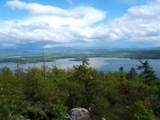
Split Rock Mountain (985') is extremely rugged with steep slopes, precipitous cliffs, and numerous rock outcrops. The lake shore is steep and densely wooded with deep bays. Several pockets of elevated wetlands are scattered in narrow ravines and in small flat areas. We'll explore the summit and it's viewpoints, as well as the view over Snake Den Harbor.
Total Distance and Elevation Gain: ~11 miles with approximately 550 feet in elevation gain (with maybe 100-150+ additional cumulative gain).
Total Time: 7-8 hours depending on breaks and group's speed.
Rain or harsh weather may postpone to another date or cancel, as appropriate.
What to Wear/Bring: Typical spring hiking gear should be appropriate: convertible hiking pants, good sturdy hiking boots with thick socks, extra layer(s)/socks and a windbreaker/raingear (just in case, carry a fleece layer). Also bring along lunch, snacks and plenty of water. Optionally, pack bug repellent and sunscreen and anything else that you may require for a day hike.
Carpooling: Contact other participants or the trip leader to arrange for a rideshare to the trailhead.
Optional Camping: I will be camping in the area the night before the hike. If anyone is interested, please contact me ahead of time.
Afterwards: If there is sufficient interest, we will have drinks and/or dinner in the area (in Essex or Westport, depending on convenience).
Directions
FROM POINTS EAST: Take the Essex-Charlotte Ferry ($10 per vehicle). Once in Essex, turn left onto Route 22 and follow for 300 feet. Continue straight onto Lakeshore Road and follow to the trailhead in 5.9 miles. The parking area will be on your left. ALTERNATIVELY, you may cross the bridge at Crown Point. From here, you will continue on Route 185W for 3.9 miles. Turn right onto Routes 22N/9N and drive for 14.1 miles. In Westport bare right onto Champlain Avenue and continue for 0.4 miles until you reach Lakeshore Road. Drive 4.3 miles to the trailhead. The parking area will be on the right.
FROM THE NORTHWAY (I-87): Use Exit 31 taking Route 9N S to Westport. Make a sharp left onto Champlain Avenue and continue for 0.4 miles until you reach Lakeshore Road. Drive 4.3 miles to the trailhead. The parking area will be on the right.
Look for a gray Hyundai Elantra.
For GPS Users: 44.233778, -73.382876 (with an approximate address of 872 Lakeshore Rd , Essex, NY).
About this event
The 3,700-acre Split Rock Mountain Wilderness area is located in the eastern foothills of the Adirondack Mountains along the shore of Lake Champlain. It comprises the largest tract of undeveloped Lake Champlain shoreline in New York. The wild forest is named for Split Rock Mountain, the main feature of the area, and refers to an unusual "split rock" formation at the northern end of the mountain where it meets Whallon Bay on Lake Champlain.
Split Rock Mountain (985') is extremely rugged with steep slopes, precipitous cliffs, and numerous rock outcrops. The lake shore is steep and densely wooded with deep bays. Several pockets of elevated wetlands are scattered in narrow ravines and in small flat areas. We'll explore the summit and it's viewpoints, as well as the view over Snake Den Harbor.
Total Distance and Elevation Gain: ~11 miles with approximately 550 feet in elevation gain (with maybe 100-150+ additional cumulative gain).
Total Time: 7-8 hours depending on breaks and group's speed.
Rain or harsh weather may postpone to another date or cancel, as appropriate.
What to Wear/Bring: Typical spring hiking gear should be appropriate: convertible hiking pants, good sturdy hiking boots with thick socks, extra layer(s)/socks and a windbreaker/raingear (just in case, carry a fleece layer). Also bring along lunch, snacks and plenty of water. Optionally, pack bug repellent and sunscreen and anything else that you may require for a day hike.
Carpooling: Contact other participants or the trip leader to arrange for a rideshare to the trailhead.
Optional Camping: I will be camping in the area the night before the hike. If anyone is interested, please contact me ahead of time.
Afterwards: If there is sufficient interest, we will have drinks and/or dinner in the area (in Essex or Westport, depending on convenience).
Directions to the trailhead
Get directionsFROM POINTS EAST: Take the Essex-Charlotte Ferry ($10 per vehicle). Once in Essex, turn left onto Route 22 and follow for 300 feet. Continue straight onto Lakeshore Road and follow to the trailhead in 5.9 miles. The parking area will be on your left. ALTERNATIVELY, you may cross the bridge at Crown Point. From here, you will continue on Route 185W for 3.9 miles. Turn right onto Routes 22N/9N and drive for 14.1 miles. In Westport bare right onto Champlain Avenue and continue for 0.4 miles until you reach Lakeshore Road. Drive 4.3 miles to the trailhead. The parking area will be on the right.
FROM THE NORTHWAY (I-87): Use Exit 31 taking Route 9N S to Westport. Make a sharp left onto Champlain Avenue and continue for 0.4 miles until you reach Lakeshore Road. Drive 4.3 miles to the trailhead. The parking area will be on the right.
Look for a gray Hyundai Elantra.
For GPS Users: 44.233778, -73.382876 (with an approximate address of 872 Lakeshore Rd , Essex, NY).
Who's going (1)
 GUEST MEMBER
 Questions about this event?
Reach out to the host, shep5, for route details, carpooling, or what to bring.
Email the hostYou can also ask in the event discussion below.
Event discussion
No comments yet.
Log in to join the conversation.