
Kinsmans Hike
An Early Spring Hike up to the Kinsmans...via the Mt Kinsman Trail.
Kinsmans Hike
An Early Spring Hike up to the Kinsmans...via the Mt Kinsman Trail.
Details
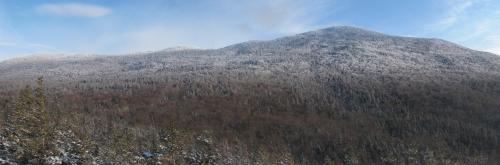
Join me for this 10.4 mile snowshoe up to the summits of the two Kinsmans...North and South (4293' and 4358', respectively). We will ascend by way of the Mount Kinsman Trail, which approaches the ridge from the west. The ridge is only 3.7 miles from this trailhead. Both of these peaks offer spectacular views. From North Kinsman there is a ledge which looks northward along the ridge as well eastward over Lonesome Lake and over to the Franconia Ridge. The more open South Kinsman provides nice views in all directions. There is an optional 0.4 mile addition on the descent to take in the view on Bald Peak (if time permits). For the most part the trail is less steep than the ascent from the east, but there will be a few short steep stretches of trail.
Total Distance and Elevation Gain: The distance is approximately the same as the eastern ascent (10.4 miles) and the elevation gain is about 3350 feet.
Total Time: 8 hours depending on breaks and group's speed.
Harsh weather may postpone to another date or cancel, as appropriate.
What to wear/bring: Traction may depend on weather conditions just prior to the hike: Snowshoes or microspikes should be adequate for most of the hike. Wear warm clothing suitable for the exposed ledge and summit(s)...no cotton or blue jeans. You should also have insulated boots suitable for the season. Additionally, consider bringing goggles, face protection and a headlamp/flashlight. Bring along plenty of water (at least 2 liters), lunch, snacks and anything else you may require for a day hike.
Carpooling: Contact other participants or the trip leader to arrange for a rideshare to the trailhead.
Afterwards: We will head back to Lincoln/North Woodstock for drinks and dinner, if there is sufficient interest (likely the Woodstock Inn).
Directions
As you pass the exit for Lincoln, continue on I-93 N for 16.0 miles. Take exit 38 toward NH-18/NH-116/NH-117/NH-142/Franconia/Sugar Hill (0.2 mile). Turn left onto NH-116 S/Easton Rd and take this for approximately 5.0 miles. The trailhead parking will be on the left...just south of the Coppermine Trailhead and Pinestead Lodge. There is a small sign for the parking area just to the south of the Franconia/Easton town line (you will see a small pond on your left). The parking lot will be on your left as you're heading south and it is set just off of the road. Total distance from Lincoln is 21.2 miles (24 minutes). Look for a grey Hyundai Elantra.
For GPS Users: 44.165517, -71.766403 (approximate address: 1628 Easton Rd, Franconia, NH)
About this event
Join me for this 10.4 mile snowshoe up to the summits of the two Kinsmans...North and South (4293' and 4358', respectively). We will ascend by way of the Mount Kinsman Trail, which approaches the ridge from the west. The ridge is only 3.7 miles from this trailhead. Both of these peaks offer spectacular views. From North Kinsman there is a ledge which looks northward along the ridge as well eastward over Lonesome Lake and over to the Franconia Ridge. The more open South Kinsman provides nice views in all directions. There is an optional 0.4 mile addition on the descent to take in the view on Bald Peak (if time permits). For the most part the trail is less steep than the ascent from the east, but there will be a few short steep stretches of trail.
Total Distance and Elevation Gain: The distance is approximately the same as the eastern ascent (10.4 miles) and the elevation gain is about 3350 feet.
Total Time: 8 hours depending on breaks and group's speed.
Harsh weather may postpone to another date or cancel, as appropriate.
What to wear/bring: Traction may depend on weather conditions just prior to the hike: Snowshoes or microspikes should be adequate for most of the hike. Wear warm clothing suitable for the exposed ledge and summit(s)...no cotton or blue jeans. You should also have insulated boots suitable for the season. Additionally, consider bringing goggles, face protection and a headlamp/flashlight. Bring along plenty of water (at least 2 liters), lunch, snacks and anything else you may require for a day hike.
Carpooling: Contact other participants or the trip leader to arrange for a rideshare to the trailhead.
Afterwards: We will head back to Lincoln/North Woodstock for drinks and dinner, if there is sufficient interest (likely the Woodstock Inn).
Directions to the trailhead
Get directionsAs you pass the exit for Lincoln, continue on I-93 N for 16.0 miles. Take exit 38 toward NH-18/NH-116/NH-117/NH-142/Franconia/Sugar Hill (0.2 mile). Turn left onto NH-116 S/Easton Rd and take this for approximately 5.0 miles. The trailhead parking will be on the left...just south of the Coppermine Trailhead and Pinestead Lodge. There is a small sign for the parking area just to the south of the Franconia/Easton town line (you will see a small pond on your left). The parking lot will be on your left as you're heading south and it is set just off of the road. Total distance from Lincoln is 21.2 miles (24 minutes). Look for a grey Hyundai Elantra.
For GPS Users: 44.165517, -71.766403 (approximate address: 1628 Easton Rd, Franconia, NH)
Who's going (2)
 GUEST MEMBER
 Questions about this event?
Reach out to the host, shep5, for route details, carpooling, or what to bring.
Email the hostYou can also ask in the event discussion below.
Event discussion
No comments yet.
Log in to join the conversation.