
Welch-Dickey Loop Trail Hike
Hike the ever popular Welch-Dickey loop trail
Welch-Dickey Loop Trail Hike
Hike the ever popular Welch-Dickey loop trail
Details
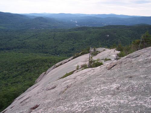
Mts. Welch and Dickey are two very popular peaks in the Waterville Valley area of NH's White Mountains. Having a southern exposure, the Welch-Dickey trail is among the first ones to clear of snow in spring. We will be doing the loop trail in a counterclockwise direction, for a total of approximately five miles. Although these mountains are under 3,000 feet in height (Mt. Dickey is the tallest at 2,700 ft), the trail is exposed throughout most of the hike. The above treeline effect is entirely man-made, as these mountains were burned of vegetation by colonial settlers in order to offer summer pasture for sheep and other farm animals. This hike is considered moderate, but there are a couple of steep ascents which will give you a bit of a workout, though mercifully, short. At this time of the year, the weather can range anywhere from a balmy sunny day, to sleet and snow, so please come prepared.
Directions
We will meet at the trailhead parking lot on Orris Road. From I-93, take exit 28 Campton/Waterville Valley, and go east on Rt. 49. After the intersection of 49 with 175 (at the Campton dam), continue 4.5 miles on 49 to the Upper Mad River Road, where you will turn left. At 0.7 miles, turn right on Orris Road, where there is a sign for the Welch-Dickey trail. Go for about half a mile, to the parking lot on the right. We will be driving a not particularly flamboyant red Toyota Rav4. Heavy precipitation will cancel this event.
About this event
Mts. Welch and Dickey are two very popular peaks in the Waterville Valley area of NH's White Mountains. Having a southern exposure, the Welch-Dickey trail is among the first ones to clear of snow in spring. We will be doing the loop trail in a counterclockwise direction, for a total of approximately five miles. Although these mountains are under 3,000 feet in height (Mt. Dickey is the tallest at 2,700 ft), the trail is exposed throughout most of the hike. The above treeline effect is entirely man-made, as these mountains were burned of vegetation by colonial settlers in order to offer summer pasture for sheep and other farm animals. This hike is considered moderate, but there are a couple of steep ascents which will give you a bit of a workout, though mercifully, short. At this time of the year, the weather can range anywhere from a balmy sunny day, to sleet and snow, so please come prepared.
Directions to the trailhead
Get directionsWe will meet at the trailhead parking lot on Orris Road. From I-93, take exit 28 Campton/Waterville Valley, and go east on Rt. 49. After the intersection of 49 with 175 (at the Campton dam), continue 4.5 miles on 49 to the Upper Mad River Road, where you will turn left. At 0.7 miles, turn right on Orris Road, where there is a sign for the Welch-Dickey trail. Go for about half a mile, to the parking lot on the right. We will be driving a not particularly flamboyant red Toyota Rav4. Heavy precipitation will cancel this event.
Who's going (5)
 SUSTAINING
  SUSTAINING
  GUEST MEMBER
 Questions about this event?
Reach out to the host, JPHiker, for route details, carpooling, or what to bring.
Email the hostYou can also ask in the event discussion below.
Event discussion
No comments yet.
Log in to join the conversation.