
Webster Slide and Mist Mtns Snowshoe
A Modest Snowshoe to the Dramatic Webster Slide and Mist Mountains.
Webster Slide and Mist Mtns Snowshoe
A Modest Snowshoe to the Dramatic Webster Slide and Mist Mountains.
Details
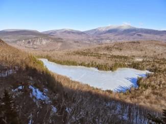
Webster Slide and Mist Mountains (2144'/2230') are the northernmost of the Middle Connecticut River Mountains, the chain of low to midsized peaks that extends SW from the Moosilauke region to the town of Hanover. Webster Slide is best known for the great cliff on its SE face, which overlooks the beautiful Wachipauka Pond at its base. The trail coincides with the AT for much of this hike. There are ample views from the pond and the summit ledges.
Total Distance and Elevation Gain: 7.2 - 8.0 miles with approximately 2000 - 2450 feet in cumulative elevation gain.
Total Time: 7 hours depending on breaks and group's speed.
Harsh weather may postpone to another date or cancel, as appropriate.
What to Bring: Snowshoes are REQUIRED and should be adequate for the entire hike (NO additional traction will be needed). Wear warm layered clothing suitable for the exposed ledge(s) and summit(s)...no cotton or blue jeans. You should also have insulated boots and gloves suitable for the season. Additionally, consider bringing goggles, face protection, hand warmers and a headlamp/flashlight. Bring along plenty of water (at least 2 liters), lunch, snacks and anything else you may require for a day hike.
Carpooling: Contact other participants or the trip leader to arrange for a rideshare to the trailhead.
Afterwards: If there is sufficient interest, we will have drinks and/or dinner in the area.
Directions
From Route 93, take Exit 26 in Plymouth and take NH Route 25 for approximately 25 miles to the AT crossing (35 minutes). Route 25 is the Tenney Mountain Highway, which turns into the Mt Moosilauke Highway. Parking will be at a roadside pulloff marked by a hiker symbol and trail sign...just past the High Street road junction in Glencliff. Look for a gray Hyundai Elantra.
For GPS Users: 43.991043, -71.900511
About this event
Webster Slide and Mist Mountains (2144'/2230') are the northernmost of the Middle Connecticut River Mountains, the chain of low to midsized peaks that extends SW from the Moosilauke region to the town of Hanover. Webster Slide is best known for the great cliff on its SE face, which overlooks the beautiful Wachipauka Pond at its base. The trail coincides with the AT for much of this hike. There are ample views from the pond and the summit ledges.
Total Distance and Elevation Gain: 7.2 - 8.0 miles with approximately 2000 - 2450 feet in cumulative elevation gain.
Total Time: 7 hours depending on breaks and group's speed.
Harsh weather may postpone to another date or cancel, as appropriate.
What to Bring: Snowshoes are REQUIRED and should be adequate for the entire hike (NO additional traction will be needed). Wear warm layered clothing suitable for the exposed ledge(s) and summit(s)...no cotton or blue jeans. You should also have insulated boots and gloves suitable for the season. Additionally, consider bringing goggles, face protection, hand warmers and a headlamp/flashlight. Bring along plenty of water (at least 2 liters), lunch, snacks and anything else you may require for a day hike.
Carpooling: Contact other participants or the trip leader to arrange for a rideshare to the trailhead.
Afterwards: If there is sufficient interest, we will have drinks and/or dinner in the area.
Directions to the trailhead
Get directionsFrom Route 93, take Exit 26 in Plymouth and take NH Route 25 for approximately 25 miles to the AT crossing (35 minutes). Route 25 is the Tenney Mountain Highway, which turns into the Mt Moosilauke Highway. Parking will be at a roadside pulloff marked by a hiker symbol and trail sign...just past the High Street road junction in Glencliff. Look for a gray Hyundai Elantra.
For GPS Users: 43.991043, -71.900511
Who's going (1)
 GUEST MEMBER
 Questions about this event?
Reach out to the host, shep5, for route details, carpooling, or what to bring.
Email the hostYou can also ask in the event discussion below.
Event discussion
Log in to join the conversation.