
Mt. Moosilauke Hike
This southwestern outpost of the high peaks is unmatched for the variety of its views!
Mt. Moosilauke Hike
This southwestern outpost of the high peaks is unmatched for the variety of its views!
Details
This southwestern outpost of the high peaks is unmatched for the variety of its views!
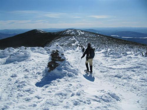
We will be hiking Mt. Moosilauke [4,802 feet] via the Glencliff Trail and Moosilauke Carriage Road to the summit of Mt. Moosilauke. The total distance covered is 7.8 miles, it should take approximately 7 hours and the elevation gain is 3,300 feet. Moosilauke has long been renowned for the breadth and variety of its views, taking in large portions of the White Mountains, central New Hampshire, the Connecticut River Valley and Vermont.
From the parking area we follow an old farm road past a gate. There is only one steep section and the footing is generally good. We reach the ridge and the Moosilauke Carriage Rd. in a sag just north of Moosilauke's South Peak. It is part of the AT. The upper part is above treeline and greatly exposed to the elements, so it can be dangerous in bad weather.
Winter conditions will be in effect so be prepared! Winter travel offers unique challenges to any hiker. Please have the appropriate gear/clothing to travel in winter like conditions and the appropriate amount of layers to keep your core body warm. Dress in synthetic layers; NO COTTON. We recommend winter boots, microspikes, wind shell, wool hat, gloves [with handwarmers if you need them], goggles, neck gaiter/balaclava/face mask; along with wearing the appropriate amount of layers to keep your body warm. Be sure to have a daypack bigger than your usual summer daypack so you can place clothing in it as you heat up. Carry at least 2 liters of water, lunch and snacks.
After the Hike: We can gather together at our Waterville Valley house around the fireplace for food and drink. Bring a change of clothes and you can take a shower to clean-up. Bring your own beverages and if you like, snacks to share. If you would like to stay for one of Jon's dinner feasts, we ask you reimburse us $5 for our food costs.
Lodging Option: Bunk beds are available at our house near Waterville Valley, NH for both Friday and Saturday nights at $20 per night. Coffee/bagels each morning and linen/blankets/towels are provided. We have limited space in the fridge to store your beverages/food so it's best to bring a small cooler. Space is limited so email ASAP to reserve a bunk!
Directions
From I-93 take the Tenney Mountain Highway Exit 26 [Plymouth, NH] and follow NH 25 to the tiny village of Glencliff, between Warren and Haverhill. Turn north [right] onto High St. [formerly Sanatorium Rd.] and drive 1.2 miles to the parking area for Glencliff Trail on right in area of fields and pastures just below Glencliff Home for the Elderly. We will be driving a blue FJ Cruiser.
About this event
This southwestern outpost of the high peaks is unmatched for the variety of its views!
We will be hiking Mt. Moosilauke [4,802 feet] via the Glencliff Trail and Moosilauke Carriage Road to the summit of Mt. Moosilauke. The total distance covered is 7.8 miles, it should take approximately 7 hours and the elevation gain is 3,300 feet. Moosilauke has long been renowned for the breadth and variety of its views, taking in large portions of the White Mountains, central New Hampshire, the Connecticut River Valley and Vermont.
From the parking area we follow an old farm road past a gate. There is only one steep section and the footing is generally good. We reach the ridge and the Moosilauke Carriage Rd. in a sag just north of Moosilauke's South Peak. It is part of the AT. The upper part is above treeline and greatly exposed to the elements, so it can be dangerous in bad weather.
Winter conditions will be in effect so be prepared! Winter travel offers unique challenges to any hiker. Please have the appropriate gear/clothing to travel in winter like conditions and the appropriate amount of layers to keep your core body warm. Dress in synthetic layers; NO COTTON. We recommend winter boots, microspikes, wind shell, wool hat, gloves [with handwarmers if you need them], goggles, neck gaiter/balaclava/face mask; along with wearing the appropriate amount of layers to keep your body warm. Be sure to have a daypack bigger than your usual summer daypack so you can place clothing in it as you heat up. Carry at least 2 liters of water, lunch and snacks.
After the Hike: We can gather together at our Waterville Valley house around the fireplace for food and drink. Bring a change of clothes and you can take a shower to clean-up. Bring your own beverages and if you like, snacks to share. If you would like to stay for one of Jon's dinner feasts, we ask you reimburse us $5 for our food costs.
Lodging Option: Bunk beds are available at our house near Waterville Valley, NH for both Friday and Saturday nights at $20 per night. Coffee/bagels each morning and linen/blankets/towels are provided. We have limited space in the fridge to store your beverages/food so it's best to bring a small cooler. Space is limited so email ASAP to reserve a bunk!
Directions to the trailhead
Get directionsFrom I-93 take the Tenney Mountain Highway Exit 26 [Plymouth, NH] and follow NH 25 to the tiny village of Glencliff, between Warren and Haverhill. Turn north [right] onto High St. [formerly Sanatorium Rd.] and drive 1.2 miles to the parking area for Glencliff Trail on right in area of fields and pastures just below Glencliff Home for the Elderly. We will be driving a blue FJ Cruiser.
Who's going (5)
 SUSTAINING
  SUSTAINING
  GUEST MEMBER
  GUEST MEMBER
 Questions about this event?
Reach out to the host, Gandalf, for route details, carpooling, or what to bring.
Email the hostYou can also ask in the event discussion below.
Event discussion
Log in to join the conversation.