
North and South Kinsman Hike
We will summit North Kinsman (4293ft.) and South Kinsman (4358ft.), two 4000 footers in the White Mountain National Forest.
North and South Kinsman Hike
We will summit North Kinsman (4293ft.) and South Kinsman (4358ft.), two 4000 footers in the White Mountain National Forest.
Details
Come along with us on a hike in the Franconia region of the White Mountains. We will summit North Kinsman (4293ft.) and South Kinsman (4358ft.), two 4000 footers in the White Mountain National Forest. This will be a long hike with rough terrain.
PLEASE READ THE ENTIRE TRIP PLAN BEFORE SIGNING UP: This will be a long, muddy, and steep hike with a lot of elevation gain. If you would like to attend you should prepare for it by evaluating your fitness level and testing your gear prior to this trip. If you have any questions, no matter how simple or complicated they are, please ask.
- Start Time: 9:00am
- Difficulty: strenuous
- Hiking pace: steady and metered
- Distance: 11.7 miles
- Elevation Gain: 3650 feet
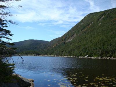
Route: We will start at The Basin parking lot (0.2mi.) and follow the Basin-Cascades Trail to the Cascade Brook Trail (1.0mi., 550ft., 45min.). We will pass by many cascades and some waterfalls on this moderate portion of trail. After following the Cascade Brook Trail for a half mile (0.5mi., 200ft., 20min.) we’ll turn left onto the Kinsman Pond Trail. This trail will be wet, steep, rocky, and rough for its 2.5 mile stretch and 1500 foot climb (2.5mi., 1500ft., 2hr.). We’ll visit Kinsman Pond then shortly reach Kinsman Junction. From the junction we will hike the Kinsman Ridge Trail to the North Kinsman summit (0.6mi., 550ft., 35min.), then we will hike to the South Kinsman summit (0.9mi., 350ft., 40min.). Once we tag the two summits we’ll backtrack to the Kinsman Junction (1.5mi., 300ft., 55min.) where we will descend using the Fishin’ Jimmy Trail to the Lonesome Lake AMC Hut (2.0mi., 200ft., 1hr.35min.). From the hut we will return using the Cascade Brook Trail (1.3mi., <1hr.) back to the Basin-Cascades Trail (1.0mi., <45min.).
Notes: Please bring plenty of water. I’ll be starting off well hydrated and with 3 liters in my pack. The first safe water source will be the Lonesome Lake hut, a mile and a half before the end of the hike. Sturdy footwear is important and avoiding cotton clothing will greatly improve comfort. Pack a lunch and plenty of calories. Please bring a flashlight just in case. The AMC hut often has some snacks and drinks for sale, so you may want to bring a few small bills. Bug repellent may help you maintain sanity.
I'll e-mail everyone who signs up more details a few days before the hike.
Directions
We will meet at The Basin parking lot which is only accessible from Interstate 93 when traveling southbound.
From points south of the white mountains: Follow Interstate 93 North through the Franconia Notch Parkway and take exit 34B (Cannon Mt. Tramway exit). Turn left twice to make a U-turn back onto Interstate 93 South. Travel 3.4 miles where you will see a sign for The Basin. Turn here for the parking area.
From points north of the White Mountains: Follow Interstate 93 South 3.4 miles past Exit 34 where you will see a sign for The Basin. Turn here for the parking area.
About this event
Come along with us on a hike in the Franconia region of the White Mountains. We will summit North Kinsman (4293ft.) and South Kinsman (4358ft.), two 4000 footers in the White Mountain National Forest. This will be a long hike with rough terrain.
PLEASE READ THE ENTIRE TRIP PLAN BEFORE SIGNING UP: This will be a long, muddy, and steep hike with a lot of elevation gain. If you would like to attend you should prepare for it by evaluating your fitness level and testing your gear prior to this trip. If you have any questions, no matter how simple or complicated they are, please ask.
- Start Time: 9:00am
- Difficulty: strenuous
- Hiking pace: steady and metered
- Distance: 11.7 miles
- Elevation Gain: 3650 feet
Route: We will start at The Basin parking lot (0.2mi.) and follow the Basin-Cascades Trail to the Cascade Brook Trail (1.0mi., 550ft., 45min.). We will pass by many cascades and some waterfalls on this moderate portion of trail. After following the Cascade Brook Trail for a half mile (0.5mi., 200ft., 20min.) we’ll turn left onto the Kinsman Pond Trail. This trail will be wet, steep, rocky, and rough for its 2.5 mile stretch and 1500 foot climb (2.5mi., 1500ft., 2hr.). We’ll visit Kinsman Pond then shortly reach Kinsman Junction. From the junction we will hike the Kinsman Ridge Trail to the North Kinsman summit (0.6mi., 550ft., 35min.), then we will hike to the South Kinsman summit (0.9mi., 350ft., 40min.). Once we tag the two summits we’ll backtrack to the Kinsman Junction (1.5mi., 300ft., 55min.) where we will descend using the Fishin’ Jimmy Trail to the Lonesome Lake AMC Hut (2.0mi., 200ft., 1hr.35min.). From the hut we will return using the Cascade Brook Trail (1.3mi., <1hr.) back to the Basin-Cascades Trail (1.0mi., <45min.).
Notes: Please bring plenty of water. I’ll be starting off well hydrated and with 3 liters in my pack. The first safe water source will be the Lonesome Lake hut, a mile and a half before the end of the hike. Sturdy footwear is important and avoiding cotton clothing will greatly improve comfort. Pack a lunch and plenty of calories. Please bring a flashlight just in case. The AMC hut often has some snacks and drinks for sale, so you may want to bring a few small bills. Bug repellent may help you maintain sanity.
I'll e-mail everyone who signs up more details a few days before the hike.
Directions to the trailhead
Get directionsWe will meet at The Basin parking lot which is only accessible from Interstate 93 when traveling southbound.
From points south of the white mountains: Follow Interstate 93 North through the Franconia Notch Parkway and take exit 34B (Cannon Mt. Tramway exit). Turn left twice to make a U-turn back onto Interstate 93 South. Travel 3.4 miles where you will see a sign for The Basin. Turn here for the parking area.
From points north of the White Mountains: Follow Interstate 93 South 3.4 miles past Exit 34 where you will see a sign for The Basin. Turn here for the parking area.
Who's going (6)


Questions about this event?
Log in to see who's hosting and to ask them questions in the event discussion.
Log in
Event discussion
No comments yet.
Log in to join the conversation.