
Balsam Lake and Graham Mountains Hike
A hike to two 3500 foot peaks with views and summit structures.
Balsam Lake and Graham Mountains Hike
A hike to two 3500 foot peaks with views and summit structures.
Details
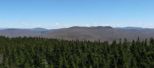
Join me for a mostly modest hike out to two of the Catskill 3500 foot peaks...Balsam Lake (3723') and Graham Mountains (3868'). Both of these peaks are accessible from a trail junction about 2.2 miles along an old jeep trail. The grades are quite modest with much of the elevation gains within about a mile before each summit. Graham Mountain is accessed via a herd path over private land, while there is a maintained DEC trail to Balsam Lake Mountain. Each mountain has views either from its summit or from its summit structure...there is an old tower installation on Graham and a restored fire tower on Balsam Lake (along with a fire warden's cabin).
Total Distance and Elevation Gain: 9.84 miles with approximately 1664 feet in accumulative elevation gain.
Total Time: 6.5 – 7 hours depending on breaks and group's speed.
Rain or harsh weather may postpone to another date or cancel, as appropriate.
Camping Option: Contact me, if you're interested in camping Friday and/or Saturday night. I would be happy to set something up or provide details to share my site. I may be staying at Little Pond Campground...contact me first to check.
What to Bring: Typical spring hiking gear should be appropriate: convertible hiking pants or shorts, good sturdy hiking boots with thick socks, a windbreaker/raingear. Also bring along lunch, snacks and plenty of water (at least 2-L). Optionally, pack sunscreen, bug spray, and anything else that you may require for a day hike.
Carpooling: Contact other participants or the trip leader to arrange for a rideshare to the trailhead.
Afterwards: If there is sufficient interest, we will have drinks and/or dinner in the area.
Directions
From the Thruway (I-87) take Exit 19 for Route 28 West and follow for 34.9 miles to the Belleayre Ski Area. Take a left onto Route 49A (Galli Curci Road, which turns into Todd Mountain Road). Follow Route 49A for 5.5 miles to the intersection with Dry Brook Road. Turn left and continue for 1.4 miles, where you'll take a right onto Mill Brook Road. The DEC trailhead will be on the right in approximately 1.5 miles. It will be a turnout along the side of the road. This is about an hour's drive from the Thruway. Look for a gray Hyundai Elantra.
For GPS Users: 42.070157, -74.573860 with an approximate address of 7349 Mill Brook Rd
Margaretville, NY 12455.
About this event
Join me for a mostly modest hike out to two of the Catskill 3500 foot peaks...Balsam Lake (3723') and Graham Mountains (3868'). Both of these peaks are accessible from a trail junction about 2.2 miles along an old jeep trail. The grades are quite modest with much of the elevation gains within about a mile before each summit. Graham Mountain is accessed via a herd path over private land, while there is a maintained DEC trail to Balsam Lake Mountain. Each mountain has views either from its summit or from its summit structure...there is an old tower installation on Graham and a restored fire tower on Balsam Lake (along with a fire warden's cabin).
Total Distance and Elevation Gain: 9.84 miles with approximately 1664 feet in accumulative elevation gain.
Total Time: 6.5 – 7 hours depending on breaks and group's speed.
Rain or harsh weather may postpone to another date or cancel, as appropriate.
Camping Option: Contact me, if you're interested in camping Friday and/or Saturday night. I would be happy to set something up or provide details to share my site. I may be staying at Little Pond Campground...contact me first to check.
What to Bring: Typical spring hiking gear should be appropriate: convertible hiking pants or shorts, good sturdy hiking boots with thick socks, a windbreaker/raingear. Also bring along lunch, snacks and plenty of water (at least 2-L). Optionally, pack sunscreen, bug spray, and anything else that you may require for a day hike.
Carpooling: Contact other participants or the trip leader to arrange for a rideshare to the trailhead.
Afterwards: If there is sufficient interest, we will have drinks and/or dinner in the area.
Directions to the trailhead
Get directionsFrom the Thruway (I-87) take Exit 19 for Route 28 West and follow for 34.9 miles to the Belleayre Ski Area. Take a left onto Route 49A (Galli Curci Road, which turns into Todd Mountain Road). Follow Route 49A for 5.5 miles to the intersection with Dry Brook Road. Turn left and continue for 1.4 miles, where you'll take a right onto Mill Brook Road. The DEC trailhead will be on the right in approximately 1.5 miles. It will be a turnout along the side of the road. This is about an hour's drive from the Thruway. Look for a gray Hyundai Elantra.
For GPS Users: 42.070157, -74.573860 with an approximate address of 7349 Mill Brook Rd
Margaretville, NY 12455.
Who's going (2)

Questions about this event?
Reach out to the host, shep5, for route details, carpooling, or what to bring.
Email the hostYou can also ask in the event discussion below.
Event discussion
No comments yet.
Log in to join the conversation.