
Spring into Summer Hike 3: N. Moat Mt.
Our third spring hike, North Moat Mountian (3196 ft.)
Spring into Summer Hike 3: N. Moat Mt.
Our third spring hike, North Moat Mountian (3196 ft.)
Details
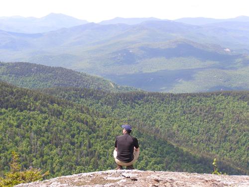
Come along on our third spring hike. On this trip we will hike North Moat Mountain (3196ft.). This mountain hugs the west side of North Conway and packs rewarding views with a decent climb.
- Start Time: 9:00am
- Difficulty: moderate-strenuous
- Hiking pace: steady with breaks
- Distance: 9 miles
- Elevation Gain: 2736 feet
We will start at the Moat Mt. Trail/Diana’s Bath parking area and hike the Moat Mt. Trail to the Red Ridge Trial. The first half mile of this leg will be a wide and easy path with several cascades and swimming holes known as Diana’s Bath, a very popular swimming destination. Once we turn onto the Red Ridge Trail we will have a brook crossing then hike a gradually descending grade for about two miles before beginning the bulk of the accent. The upper part of this trail will be on open ledges with many views. Here, we will have lunch. We will turn north onto the Moat Mountain Trail and traverse the Red Ridge, with some easy scrambles, to the summit of North Moat Mountain in about a mile to enjoy the summit views. To descend we will continue north on the Moat Mountain Trail. It will be a steady and relatively steep decent for the first half, will have a river crossing, then a level hike for several miles back to the parking area.
Please bring plenty of water and a lunch/snacks. Shoes with good traction on rock and loose gravel is strongly encouraged. Sunblock and bug spray is recommended. Black flies may be a significant nuisance.
As the trip date comes closer I will send additional information to everyone who signed up. Please feel free to contact Mark or me with any questions you may have about the hike. Poor weather will postpone or cancel this hike.
Directions
Approach using NH Route 16 north: From the junction of NH Route 112 (Kancamagus Highway) and NH Route 16 drive north 0.8 miles and turn left onto Washington Street at the first stop light. In 0.2 miles turn slightly left onto West Side Drive. Drive 5.1 miles to a “T” intersection for River Road and turn left staying on West Side Drive. Drive 1.4 miles more north on West Side Drive. The parking lot will be on the left side and easy to spot.
Approach using NH Route 302 east: From the Attitash ski area drive about 1.6 miles east and turn right onto West Side Road. Follow West Side Road for 4.2 miles and the parking lot will be on the right side and easy to spot.
About this event
Come along on our third spring hike. On this trip we will hike North Moat Mountain (3196ft.). This mountain hugs the west side of North Conway and packs rewarding views with a decent climb.
- Start Time: 9:00am
- Difficulty: moderate-strenuous
- Hiking pace: steady with breaks
- Distance: 9 miles
- Elevation Gain: 2736 feet
We will start at the Moat Mt. Trail/Diana’s Bath parking area and hike the Moat Mt. Trail to the Red Ridge Trial. The first half mile of this leg will be a wide and easy path with several cascades and swimming holes known as Diana’s Bath, a very popular swimming destination. Once we turn onto the Red Ridge Trail we will have a brook crossing then hike a gradually descending grade for about two miles before beginning the bulk of the accent. The upper part of this trail will be on open ledges with many views. Here, we will have lunch. We will turn north onto the Moat Mountain Trail and traverse the Red Ridge, with some easy scrambles, to the summit of North Moat Mountain in about a mile to enjoy the summit views. To descend we will continue north on the Moat Mountain Trail. It will be a steady and relatively steep decent for the first half, will have a river crossing, then a level hike for several miles back to the parking area.
Please bring plenty of water and a lunch/snacks. Shoes with good traction on rock and loose gravel is strongly encouraged. Sunblock and bug spray is recommended. Black flies may be a significant nuisance.
As the trip date comes closer I will send additional information to everyone who signed up. Please feel free to contact Mark or me with any questions you may have about the hike. Poor weather will postpone or cancel this hike.
Directions to the trailhead
Get directionsApproach using NH Route 16 north: From the junction of NH Route 112 (Kancamagus Highway) and NH Route 16 drive north 0.8 miles and turn left onto Washington Street at the first stop light. In 0.2 miles turn slightly left onto West Side Drive. Drive 5.1 miles to a “T” intersection for River Road and turn left staying on West Side Drive. Drive 1.4 miles more north on West Side Drive. The parking lot will be on the left side and easy to spot.
Approach using NH Route 302 east: From the Attitash ski area drive about 1.6 miles east and turn right onto West Side Road. Follow West Side Road for 4.2 miles and the parking lot will be on the right side and easy to spot.
Who's going (3)

Questions about this event?
Log in to see who's hosting and to ask them questions in the event discussion.
Log in
Event discussion
No comments yet.
Log in to join the conversation.