
Jay Peak and Big Jay Hike
Join us for change of scenery by the Canadian border hiking up these New England 100 highest peaks!
Jay Peak and Big Jay Hike
Join us for change of scenery by the Canadian border hiking up these New England 100 highest peaks!
Details
Join us for change of scenery by the Canadian border hiking up these New England 100 highest peaks!
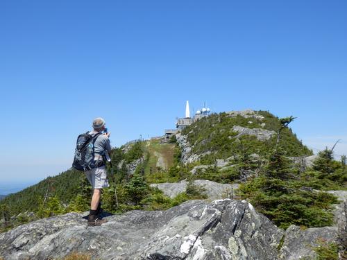
The panoramic views from the summit of Jay Peak is superb! We can buy lunch and a beer in the summit restaurant. Jay Peak is 3,858 feet high and Big Jay is 3,786 feet.
Jay Peak is on the Long Trail but Big Jay is not. We'll be taking a herd path from Jay Peak to Big Jay during our hike. If you're only interested in going to Jay Peak but not Big Jay, you can feel free to skip Big Jay and return to your car on your own.
This is a round trip hike which doesn't require a car spot. Total mileage is 5.25 miles [3.4 miles if you only go to Jay Peak] with 2,500 feet of elevation gain. The Long Trail follows the main ridge of the Green Mountains from Masschusetts to the Canadian border and it crosses Vermont's highest mountains including Jay Peak.
The 1.7 mile section of the trail to the summit is a beautiful hike which climbs 1,526 feet up the back side of Jay Peak to the rewarding views at the summit. After reaching the summit of Jay Peak, we follow the Long Trail a few dozen steps further to find the herd path on the left side. This is the path we'll be taking to reach Big Jay. Herd path hiking won't be so challenging except for a section of boot sucking hungry mud! It might be a good idea to wear gaiters if you have them. Elevation gain is approximately 466 feet. It may take an additional 1.5 hours to include Big Jay into our hike. There is a canister at the summit of Big Jay with a logbook to register proof of our hike.
We take the same route back to the parking lot: herd path and Long Trail. We are planning on 5.5 hours to complete this trip.
Lodging Option: Since the trailhead is a two hour drive from our riverside house in Waterville Valley NH we suggest you spend both Friday and Saturday night with us. We can carpool from the house to the trailhead. We have bunk beds, it's $20 per night and includes breakfast/coffee in the morning. When we get back from the hike we can take showers and have a cookout from our deck with wonderful views of the Sandwich Mountain! We charge an additional $5 for dinner to defray our cost. Let us know you want a bunk and whether its for Friday or Friday/Saturday.
Directions
The trailhead is at the very top of Vermont, near the Canadian border. It is way north of the town of St. Johnsbury, VT. To get some idea of travel, it you started from Nashua, NH it is 200 miles and it will take you 3 1/2 hours to get there. From our house in Waterville Valley, it will take 2 hours to get there.
We will be meeting at the Long Trail parking lot on Route 242. If you use a GPS, here are the parking lot coordinates in degrees and minutes:
N 44 54.768
W 72 30.241
Directions [we recommend looking at a map before leaving since there are many routes] :
- Route 93 north [into Vermont]
- Route 91 north to Exit 26
- Route 5 north [for 5.8 miles]
- Route 14 northwest [for 4.8 miles]
- Route 100 southwest [for 5.7 miles]
- Route 101 north [for 3.1 miles]
- Route 242 west [for 6.4 miles]
While carpooling is encouraged, you are responsible for your own rides. Use the comments section below to communicate with others who may be looking to share a ride. If you share a ride, be sure to share expenses.
About this event
Join us for change of scenery by the Canadian border hiking up these New England 100 highest peaks!
The panoramic views from the summit of Jay Peak is superb! We can buy lunch and a beer in the summit restaurant. Jay Peak is 3,858 feet high and Big Jay is 3,786 feet.
Jay Peak is on the Long Trail but Big Jay is not. We'll be taking a herd path from Jay Peak to Big Jay during our hike. If you're only interested in going to Jay Peak but not Big Jay, you can feel free to skip Big Jay and return to your car on your own.
This is a round trip hike which doesn't require a car spot. Total mileage is 5.25 miles [3.4 miles if you only go to Jay Peak] with 2,500 feet of elevation gain. The Long Trail follows the main ridge of the Green Mountains from Masschusetts to the Canadian border and it crosses Vermont's highest mountains including Jay Peak.
The 1.7 mile section of the trail to the summit is a beautiful hike which climbs 1,526 feet up the back side of Jay Peak to the rewarding views at the summit. After reaching the summit of Jay Peak, we follow the Long Trail a few dozen steps further to find the herd path on the left side. This is the path we'll be taking to reach Big Jay. Herd path hiking won't be so challenging except for a section of boot sucking hungry mud! It might be a good idea to wear gaiters if you have them. Elevation gain is approximately 466 feet. It may take an additional 1.5 hours to include Big Jay into our hike. There is a canister at the summit of Big Jay with a logbook to register proof of our hike.
We take the same route back to the parking lot: herd path and Long Trail. We are planning on 5.5 hours to complete this trip.
Lodging Option: Since the trailhead is a two hour drive from our riverside house in Waterville Valley NH we suggest you spend both Friday and Saturday night with us. We can carpool from the house to the trailhead. We have bunk beds, it's $20 per night and includes breakfast/coffee in the morning. When we get back from the hike we can take showers and have a cookout from our deck with wonderful views of the Sandwich Mountain! We charge an additional $5 for dinner to defray our cost. Let us know you want a bunk and whether its for Friday or Friday/Saturday.
Directions to the trailhead
Get directionsThe trailhead is at the very top of Vermont, near the Canadian border. It is way north of the town of St. Johnsbury, VT. To get some idea of travel, it you started from Nashua, NH it is 200 miles and it will take you 3 1/2 hours to get there. From our house in Waterville Valley, it will take 2 hours to get there.
We will be meeting at the Long Trail parking lot on Route 242. If you use a GPS, here are the parking lot coordinates in degrees and minutes:
N 44 54.768
W 72 30.241
Directions [we recommend looking at a map before leaving since there are many routes] :
- Route 93 north [into Vermont]
- Route 91 north to Exit 26
- Route 5 north [for 5.8 miles]
- Route 14 northwest [for 4.8 miles]
- Route 100 southwest [for 5.7 miles]
- Route 101 north [for 3.1 miles]
- Route 242 west [for 6.4 miles]
While carpooling is encouraged, you are responsible for your own rides. Use the comments section below to communicate with others who may be looking to share a ride. If you share a ride, be sure to share expenses.
Who's going (5)

Questions about this event?
Reach out to the host, Gandalf, for route details, carpooling, or what to bring.
Email the hostYou can also ask in the event discussion below.
Event discussion
Log in to join the conversation.