
East Mountain Hike
An Unusual Hike to the Top of East Mountain and its Abandoned US Air Force Base.
East Mountain Hike
An Unusual Hike to the Top of East Mountain and its Abandoned US Air Force Base.
Details
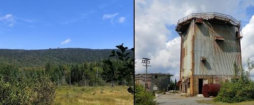
Join me for a relatively modest hike up East Mountain, which will provide an opportuntity to see some unusual relics left behind from the Cold War. East Mountain (3439') is the highest point in Essex County, VT. It also ranks as 46th on the list of Vermont's 50 highest peaks and is 29th on the list known as New England Fifty Finest Peaks. This now abandoned radar station and base was commissioned in 1952 by the US Air Force, and it was operational by 1955. It was originally known as the North Concord Air Force Station, but later changed in 1962 to Lyndonville Air Force Station. This facility saw most of its use during the Cold War. It was one of many ground-based radar stations that were scattered around the U.S. at the time, and was used to seek out Russian planes or missiles entering U.S air space. The site was abandoned in 1963, and the rundown buildings now serve as a reminder of the Cold War. This is an out-and-back hike along an old access road. There are some views along the route, but it is for the most part heavily treed. The real attraction are the summit structures as well as the supporting structures half way up the mountain.
Total Distance and Elevation Gain: 7-8 miles with approximately 1640 feet in elevation gain.
Total Time: 5-6 hours depending on breaks and group's speed.
Harsh weather may postpone to another date or cancel, as appropriate.
What to Bring: Typical early spring hiking gear should be appropriate: convertible hiking pants, good sturdy hiking boots with thick socks, a windbreaker/raingear and extra layers (e.g. fleece). Also bring along lunch, snacks and plenty of water (at least 2-L). Optionally, pack sunscreen, bug spray, and anything else that you may require for a day hike.
Carpooling: Contact other participants or the trip leader to arrange for a rideshare to the trailhead. Carpooling is encouraged particularly for the forest/logging roads. Options will be provided the week of the trip for those interested.
Afterwards: If there is sufficient interest, we will have drinks and/or dinner in the Burke/Lyndon area afterwards.
Directions
From Route 91 take Exit 23 for Route 5 North. Take this for 2.5 miles and then take Route 114 North for 6.8 miles. Turn right onto Victory Road and continue for 7.6 miles. This road will be slow as it's an unpaved, grated road. At Gallup Mills, turn left onto Radar Road and continue north for 4.4 miles. Parking will be off the road just prior to the gate. Look for a gray Hyundai Elantra.
NOTE: This is a forestry management area and there may be logging trucks. They have the right-of-way and parking must be well off the road. There is a wide clearing for this purpose before the gate.
From northern NH, it may also be convenient to access the area from Granby...taking Granby Road west. Radar Road turns north from the junctions of Victory, Radar, River and Granby roads.
For GPS Users: 44.633933, -71.810867 (4134 Radar Rd; East Haven, VT 05837 - approximate address)
About this event
Join me for a relatively modest hike up East Mountain, which will provide an opportuntity to see some unusual relics left behind from the Cold War. East Mountain (3439') is the highest point in Essex County, VT. It also ranks as 46th on the list of Vermont's 50 highest peaks and is 29th on the list known as New England Fifty Finest Peaks. This now abandoned radar station and base was commissioned in 1952 by the US Air Force, and it was operational by 1955. It was originally known as the North Concord Air Force Station, but later changed in 1962 to Lyndonville Air Force Station. This facility saw most of its use during the Cold War. It was one of many ground-based radar stations that were scattered around the U.S. at the time, and was used to seek out Russian planes or missiles entering U.S air space. The site was abandoned in 1963, and the rundown buildings now serve as a reminder of the Cold War. This is an out-and-back hike along an old access road. There are some views along the route, but it is for the most part heavily treed. The real attraction are the summit structures as well as the supporting structures half way up the mountain.
Total Distance and Elevation Gain: 7-8 miles with approximately 1640 feet in elevation gain.
Total Time: 5-6 hours depending on breaks and group's speed.
Harsh weather may postpone to another date or cancel, as appropriate.
What to Bring: Typical early spring hiking gear should be appropriate: convertible hiking pants, good sturdy hiking boots with thick socks, a windbreaker/raingear and extra layers (e.g. fleece). Also bring along lunch, snacks and plenty of water (at least 2-L). Optionally, pack sunscreen, bug spray, and anything else that you may require for a day hike.
Carpooling: Contact other participants or the trip leader to arrange for a rideshare to the trailhead. Carpooling is encouraged particularly for the forest/logging roads. Options will be provided the week of the trip for those interested.
Afterwards: If there is sufficient interest, we will have drinks and/or dinner in the Burke/Lyndon area afterwards.
Directions to the trailhead
Get directionsFrom Route 91 take Exit 23 for Route 5 North. Take this for 2.5 miles and then take Route 114 North for 6.8 miles. Turn right onto Victory Road and continue for 7.6 miles. This road will be slow as it's an unpaved, grated road. At Gallup Mills, turn left onto Radar Road and continue north for 4.4 miles. Parking will be off the road just prior to the gate. Look for a gray Hyundai Elantra.
NOTE: This is a forestry management area and there may be logging trucks. They have the right-of-way and parking must be well off the road. There is a wide clearing for this purpose before the gate.
From northern NH, it may also be convenient to access the area from Granby...taking Granby Road west. Radar Road turns north from the junctions of Victory, Radar, River and Granby roads.
For GPS Users: 44.633933, -71.810867 (4134 Radar Rd; East Haven, VT 05837 - approximate address)
Who's going (5)




Questions about this event?
Reach out to the host, shep5, for route details, carpooling, or what to bring.
Email the hostYou can also ask in the event discussion below.
Event discussion
No comments yet.
Log in to join the conversation.