
Mount Mansfield Loop Hike
A spring trek to Vermont's highest peak...via the Long Trail from Smuggler's Notch.
Mount Mansfield Loop Hike
A spring trek to Vermont's highest peak...via the Long Trail from Smuggler's Notch.
Details
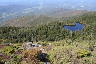
Join me for this hike up Mount Mansfield, which is Vermont's highest peak at 4,393 feet. This will be an out-an-back hike utilizing the Long Trail from Smuggler's Notch. The trail presents a steady climb to this impressive summit (known as the Chin-part of the profile). We'll pass the Taft Lodge...the historic Long Trail lodge run by the Green Mountain Club. The summit is 0.6 miles beyond the lodge and there are excellent views of the its rocky summit frequently from the lodge and thereafter. While this route is fairly well protected from the severest of the elements, the route has a few steep areas and it will be very exposed for the short distance beyond the lodge. On the return, we will take the Hell Brook Trail, which will allow us to explore the Lake of the Clouds and Adam's Apple before continuing the descent back to the notch and the cars.
Total Distance and Elevation Gain: 5.9-6.2 miles with approximately 3000 feet in accumulative elevation gain.
Total Time: 6-7 hours depending on breaks and group's speed.
Harsh winter weather may postpone to another date or cancel, as appropriate.
What to Bring: Typical early spring hiking gear should be appropriate: convertible hiking pants, good sturdy hiking boots with thick socks, a windbreaker/raingear and extra layers (e.g. fleece). Also bring along lunch, snacks and plenty of water (at least 2-L). Optionally, pack sunscreen, bug spray, and anything else that you may require for a day hike.
Carpooling: Contact other participants or the trip leader to arrange for a rideshare to the trailhead.
Afterwards: If there is sufficient interest, we will have drinks and/or dinner in the Stowe area afterwards.
Directions
We will meet up just after the Stowe Ski Area and before the gate on Rt 108.
From I-89, take Exit 10 for VT-100 N towards Waterbury. Drive for about 9.5 miles and then take a left onto VT-108 N (Mountain Road). After 7.8 miles you will have just passed the Stowe Ski area and will be near the gate for the road through Smuggler's Notch (VT-108). Parking is along the road on the left. Look for a gray Hyundai Elantra.
For GPS Users: 7780 Mountain Rd; Stowe, VT 05672 (44.533265,-72.78685)...approximate location of winter parking near Barnes Camp...just before the point where Route 108 is gated.
About this event
Join me for this hike up Mount Mansfield, which is Vermont's highest peak at 4,393 feet. This will be an out-an-back hike utilizing the Long Trail from Smuggler's Notch. The trail presents a steady climb to this impressive summit (known as the Chin-part of the profile). We'll pass the Taft Lodge...the historic Long Trail lodge run by the Green Mountain Club. The summit is 0.6 miles beyond the lodge and there are excellent views of the its rocky summit frequently from the lodge and thereafter. While this route is fairly well protected from the severest of the elements, the route has a few steep areas and it will be very exposed for the short distance beyond the lodge. On the return, we will take the Hell Brook Trail, which will allow us to explore the Lake of the Clouds and Adam's Apple before continuing the descent back to the notch and the cars.
Total Distance and Elevation Gain: 5.9-6.2 miles with approximately 3000 feet in accumulative elevation gain.
Total Time: 6-7 hours depending on breaks and group's speed.
Harsh winter weather may postpone to another date or cancel, as appropriate.
What to Bring: Typical early spring hiking gear should be appropriate: convertible hiking pants, good sturdy hiking boots with thick socks, a windbreaker/raingear and extra layers (e.g. fleece). Also bring along lunch, snacks and plenty of water (at least 2-L). Optionally, pack sunscreen, bug spray, and anything else that you may require for a day hike.
Carpooling: Contact other participants or the trip leader to arrange for a rideshare to the trailhead.
Afterwards: If there is sufficient interest, we will have drinks and/or dinner in the Stowe area afterwards.
Directions to the trailhead
Get directionsWe will meet up just after the Stowe Ski Area and before the gate on Rt 108.
From I-89, take Exit 10 for VT-100 N towards Waterbury. Drive for about 9.5 miles and then take a left onto VT-108 N (Mountain Road). After 7.8 miles you will have just passed the Stowe Ski area and will be near the gate for the road through Smuggler's Notch (VT-108). Parking is along the road on the left. Look for a gray Hyundai Elantra.
For GPS Users: 7780 Mountain Rd; Stowe, VT 05672 (44.533265,-72.78685)...approximate location of winter parking near Barnes Camp...just before the point where Route 108 is gated.
Who's going (6)




Questions about this event?
Reach out to the host, shep5, for route details, carpooling, or what to bring.
Email the hostYou can also ask in the event discussion below.
Event discussion
Log in to join the conversation.