
Dryad and Giant Falls Loop Hike
A Loop Hike with Dramatic Waterfalls, a Mountain Lake and Surrounding Peak Views.
Dryad and Giant Falls Loop Hike
A Loop Hike with Dramatic Waterfalls, a Mountain Lake and Surrounding Peak Views.
Details
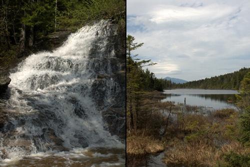
Join me for a modest jaunt into the lower Mahoosuc Region, where we'll visit two spectacular waterfalls...the 300-foot Dryad Falls and the beautiful cascading Giant Falls...and the shores of Dream Lake. Along the way there will be ledges with views over the Androscoggin Valley as well as over to the Carter and Presidential Ranges, from the trail and from the modest summit of Bald Cap Peak (2795'). To make this loop a little easier, we'll spot cars...taking the Austin Brook Trail up and returning via the Peabody Brook Trail.
Total Distance and Elevation Gain: Approximately 8.5 miles with 2300 ft elevation gain. There are portions of this hike that are modestly steep.
Total Time: 6.5 hours depending on breaks and group's speed.
Rain or harsh weather may postpone to another date or cancel, as appropriate.
What to Bring: Typical early spring hiking gear should be appropriate: convertible hiking pants, good sturdy hiking boots with thick socks, a windbreaker/raingear and extra layers (e.g. fleece). Also bring along lunch, snacks and plenty of water (at least 2-L). Optionally, pack sunscreen, bug spray, and anything else that you may require for a day hike. NOTE: Significant snow and ice and, therefore, traction should not be an issue
Carpooling: Contact other participants or the trip leader to arrange for a rideshare to the trailhead.
Afterwards: If there is sufficient interest, we will have drinks and/or dinner in the Gorham area afterwards.
Directions
From the eastern junction of Rts 16 and 2 in Gorham (NH), continue on Rt. 2 East for 3.4 miles. Turn left onto North Road (just past where the Androscoggin River Reservoir parallels the Rt. 2) and proceed about 1.3-1.4 miles. Parking is along the road and is limited. If you pass over the Peabody Brook, you've gone just a tad too far. Look for a gray Hyundai Elantra.
For GPS Users: 44.413334, -71.104034 (265 North Rd; Shelburne, NH 03581)
About this event
Join me for a modest jaunt into the lower Mahoosuc Region, where we'll visit two spectacular waterfalls...the 300-foot Dryad Falls and the beautiful cascading Giant Falls...and the shores of Dream Lake. Along the way there will be ledges with views over the Androscoggin Valley as well as over to the Carter and Presidential Ranges, from the trail and from the modest summit of Bald Cap Peak (2795'). To make this loop a little easier, we'll spot cars...taking the Austin Brook Trail up and returning via the Peabody Brook Trail.
Total Distance and Elevation Gain: Approximately 8.5 miles with 2300 ft elevation gain. There are portions of this hike that are modestly steep.
Total Time: 6.5 hours depending on breaks and group's speed.
Rain or harsh weather may postpone to another date or cancel, as appropriate.
What to Bring: Typical early spring hiking gear should be appropriate: convertible hiking pants, good sturdy hiking boots with thick socks, a windbreaker/raingear and extra layers (e.g. fleece). Also bring along lunch, snacks and plenty of water (at least 2-L). Optionally, pack sunscreen, bug spray, and anything else that you may require for a day hike. NOTE: Significant snow and ice and, therefore, traction should not be an issue
Carpooling: Contact other participants or the trip leader to arrange for a rideshare to the trailhead.
Afterwards: If there is sufficient interest, we will have drinks and/or dinner in the Gorham area afterwards.
Directions to the trailhead
Get directionsFrom the eastern junction of Rts 16 and 2 in Gorham (NH), continue on Rt. 2 East for 3.4 miles. Turn left onto North Road (just past where the Androscoggin River Reservoir parallels the Rt. 2) and proceed about 1.3-1.4 miles. Parking is along the road and is limited. If you pass over the Peabody Brook, you've gone just a tad too far. Look for a gray Hyundai Elantra.
For GPS Users: 44.413334, -71.104034 (265 North Rd; Shelburne, NH 03581)
Who's going (3)
 GUEST MEMBER
  GUEST MEMBER
  SUSTAINING
 Questions about this event?
Reach out to the host, shep5, for route details, carpooling, or what to bring.
Email the hostYou can also ask in the event discussion below.
Event discussion
Log in to join the conversation.